Invest 95L to become Lee, likely major hurricane within days as system gains strength in the Atlantic
Forecasters are confident Invest 95L will become a tropical depression or Tropical Storm Lee within the next day or so, and then become a major hurricane by the end of the week.
Invest 95L will develop into tropical depression or storm, NHC says
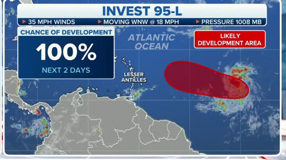
With the latest advisory the National Hurricane Center says there is 100% certainty Invest 95L will develop into a tropical depression or Tropical Storm Lee within the next 2 days. Another system, Invest 96L, off of Africa is also being monitored for likely development.
As of Tuesday at 11:00 AM, Tropical Depression Thirteen has formed and is forecast to become a major hurricane this week. Continuous coverage of Tropical Depression Thirteen has moved here.
A tropical disturbance spinning across the Atlantic Ocean after moving off the coast of Africa last week has been dubbed Invest 95L and will become the next named tropical system and possible major hurricane as it marches across the ocean.
An "invest" is a designation given by the National Hurricane Center for tropical disturbances that warrant additional monitoring.
Showers and thunderstorms associated with Invest 95L became better organized overnight as the area of low pressure continued to spin to the west-southwest of the Cabo Verde Islands.
Computer models are in unanimous agreement due to the low wind shear, little dry air and warm sea surface temperatures, environmental conditions are favorable for further development. The National Hurricane Center (NHC) says a tropical depression or tropical storm will develop within the next 48 hours while the system moves to the west-northwest at 15-20 mph across the central Atlantic Ocean.
When the system develops into a tropical storm, it will be named Lee.
Additional strengthening to a major hurricane (Category 3 or higher) is likely later this week while the system moves over western portions of the Atlantic Ocean, near or to the northeast of the northern Leeward Islands, according to the FOX Forecast Center.
If the storm reaches Category 3 or higher, it will become our third major hurricane of the season behind Franklin and Idalia.

(FOX Weather)
"It will be important to stay informed in the northeastern Caribbean to be sure likely-Lee pays attention to the consensus of the computer models," said FOX Weather Hurricane Specialist Bryan Norcross.
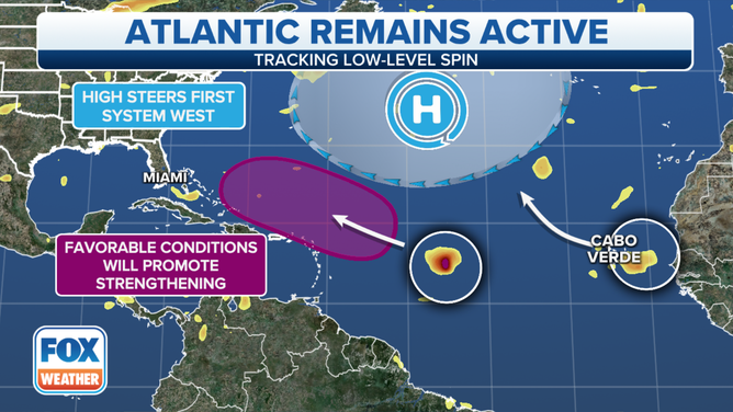
Atlantic remains active. Sept. 4, 2023.
(FOX Forecast Center / FOX Weather)
TROPICAL CYCLONES CHURN IN THE ATLANTIC BUT THREATS REMAIN AT BAY FOR NOW
The FOX Forecast Center said that once Invest 95L clears the Caribbean Islands, the most likely outcome as of right now is a recurve out to sea. While this is the more favored outcome, it is too early to confidentially say whether the U.S. will avoid any impacts.
"There is a strong consensus the system will not track directly to the U.S. coast, but at some point near or north of the islands, the steering currents might collapse," Norcross continued. "After that, there are multiple possibilities. We’ll likely be watching this system well into next week."