Bryan Norcross: Atlantic disturbance (#95l) is slow organizing – looks like a close call for the islands
The system is slowly pulling itself together and should have sufficient organization to be designated a tropical depression in the next day or two.

FOX Weather is your Hurricane HQ, streaming free 24/7.
(FOX Weather / FOX Weather)
Updated at 9:00 AM
Tropical Disturbance #1 is now officially named Invest #95L, which means the National Hurricane Center is investigating it with extra computer analysis. The system is slowly pulling itself together and should have sufficient organization to be designated a tropical depression in the next day or two. All indications are that it will become Tropical Storm and possibly Hurricane Lee during its trek over the tropical Atlantic.
The National Hurricane Center sets the odds as very high that the disturbance will become at least a depression. On the current schedule, likely-eventually-Lee will be in the general vicinity of the northeastern Caribbean islands over the weekend.
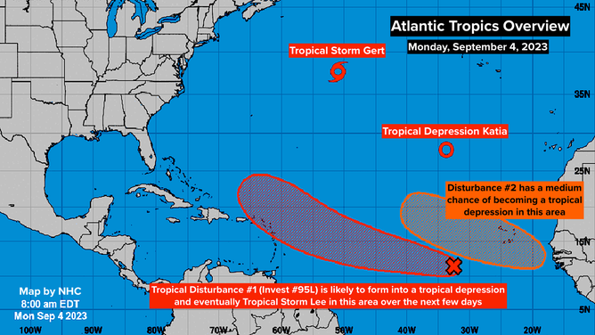
Atlantic Tropics Overview. Sept. 4, 2023.
(National Hurricane Center / NOAA)
The NHC’s development zone and the majority of the computer forecasts show tracks just to the north of the islands, but it’s too soon to be 100% sure. It’s a close call.
The blocking high-pressure system sprawled across the Atlantic, which is propelling the disturbance to the west, is forecast to be weakened by a couple of areas of low pressure. The weakened high will allow the system’s track to bend north to some degree, but the amount of the bend depends on how much the high is weakened and how strong the system becomes.
It will be important to stay informed in the northeastern Caribbean to be sure likely-Lee pays attention to the consensus of the computer models.
The long-range forecasts for likely-Lee are fuzzy. There is a strong consensus the system will not track directly to the U.S. coast, but at some point near or north of the islands, the steering currents might collapse. After that, there are multiple possibilities. We’ll likely be watching this system well into next week.
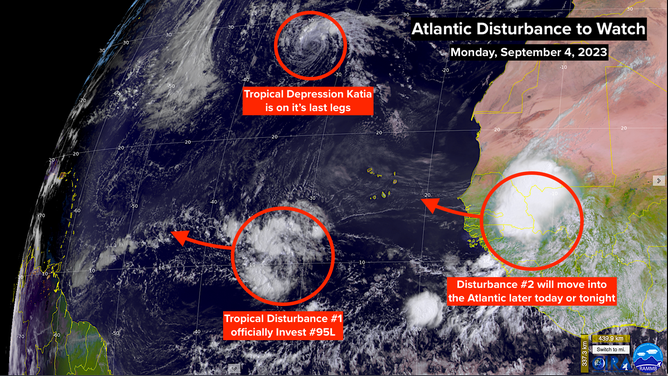
Atlantic Disturbance to Watch. Sept. 4, 2023.
(CIRA / RAAMB / FOX Weather)
Over Africa, Disturbance #2 is a robust cluster of thunderstorms. It is forecast to move into the Atlantic late today or tomorrow. The system is expected to veer to the north and might impact the Cabo Verde Islands. The National Hurricane Center is giving it a medium chance of developing into at least a tropical depression. It is not expected to advance very far west.
Farther north, Gert and Katia are in their last hours and are no threat to land.
It looks like likely-Lee will take us past the peak of the hurricane season, which is coming next weekend.