Severe weather alerts issued for Texas as thunderstorms, large hail threaten post-eclipse travel
the Dallas-Fort Worth Metroplex has been upgraded to a Level 3 out of 5 risk of severe weather because of the threat of very large hail upwards of 2 inches or greater in diameter. This Level 3 risk covers much of north-central and northwestern Texas.
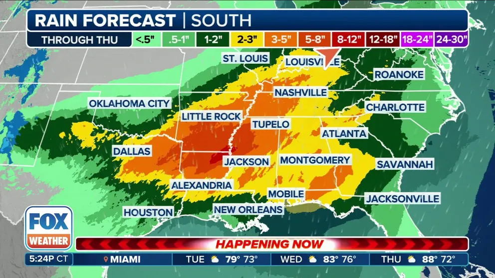
Rounds of rain to soak parts of Mississippi and Tennessee valleys
A slow moving storm system is expected to produce several round of precipitation across the South and Tennessee Valley through the workweek.
DALLAS – Severe weather managed to hold off from thwarting any solar eclipse viewing, but it still remains a threat to much of Texas and into neighboring states Monday evening and night as millions make their trek home.
LIVE COVERAGE: TOTAL SOLAR ECLIPSE APRIL 2024
A Tornado Watch is in effect until 8 p.m. CT stretching from eastern Texas into northern Louisiana.
Additionally, a Severe Thunderstorm Watch was issued for communities around Abilene until well after sunset.

(FOX Weather)
Supercell thunderstorms are expected to increase in coverage and intensity Monday evening across the region, with threats of a few tornadoes, wind gusts over 70 mph and very large hail that could exceed 3 inches in diameter.

(FOX Weather)
NOAA's Storm Prediction Center (SPC) has a large swath of northeastern Texas, including the Dallas-Fort Worth Metroplex, in a Level 3 out of 5 risk of severe weather because of the threat of very large hail upwards of 3 inches or greater in diameter.

(FOX Weather)
The Level 3 threat now extends even into Shreveport and northwestern Louisiana.
The dangerous forecast forced the early cancelation of a major music festival in Burnet, Texas.
The Texas Eclipse 2024 festival organizers announced Monday morning that due to the risks of high winds, tornadic activity and thunderstorms later Monday through Wednesday "we've agreed to end the festival (Monday) in a calm, orderly manner." All performances were canceled, but guests were allowed to stay for the eclipse provided they are packed and ready to leave at its conclusion.
BUZZWORDS YOU COULD HEAR DURING SEVERE WEATHER
Computer forecast models are painting a rather complex situation with an upper-level low-pressure system that will move into the Desert Southwest on Monday, interacting with a moist air mass and deep wind shear – the change in wind speed and/or direction with height – in place from much of Central, North and East Texas eastward into Louisiana, the SPC noted.
Severe weather could catch travelers off guard after the eclipse
While the thunderstorms held off for the main eclipse event, strong to severe thunderstorms look to cover much of what was the eclipse's path throughout much of Texas and Arkansas by Monday evening into Monday night.
Thunderstorms and hailstorms could catch travelers off guard in what is expected to be heavy traffic through the rest of Monday as eclipse gazers head home, and it could be especially harrowing for visitors to the region with less severe weather experience.
If caught driving in a large hailstorm, pull well off the road as driving compounds a hailstone's impact with your car. While stopping under an overpass may look enticing, safety experts say don't stop there as you may create accidents on the highway, according to hail safety tips from the Oklahoma Department of Transportation. If stopped and still exposed to hail, angle your car to where the windshield is facing the hail as windshields are reinforced to withstand forward driving and pelting objects.
The severe weather threat extends through much of the day Tuesday with nearly the same area under an ongoing Level 3 severe weather risk, with just a slight shift to the east.

(FOX Weather)
The severe weather keeps shifting east through much of the week, with the Gulf Coast under threat on Wednesday and the Southeast Coast on Thursday.
Meanwhile, FOX Weather is keeping you updated on the forecast along the entire path of totality as Monday's big event approaches.