Multiday severe weather pattern covers Gulf Coast, South with threat of tornadoes, large hail
The severe weather threat begins Monday over the southern Plains as millions attempt to catch a glimpse of the total solar eclipse when it first enters the U.S. in Texas during the afternoon.
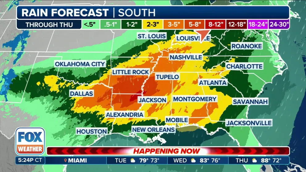
Rounds of rain to soak parts of Mississippi and Tennessee valleys
A slow moving storm system is expected to produce several round of precipitation across the South and Tennessee Valley through the workweek.
A very stormy week is on tap for much of the Gulf Coast and South as a stubborn and dangerous severe weather pattern takes shape, threatening very large hail, damaging wind gusts and possible tornadoes – many of which may occur during the overnight hours.
A weather disturbance will slowly drift east out of the Desert Southwest early this week. Ahead of that, warm, humid Gulf of Mexico air will stream north, providing proverbial fuel for the fire. On Monday, a decaying cold front will be the focus of the thunderstorms before a developing storm system takes over.

(FOX Weather)
This means the week ahead will feature day after day and round after round of thunderstorms with heavy rain, very large hail, damaging winds and possible tornadoes. The repeated soakings set several cities up for multiple inches of rain.
Jackson, Mississippi, and Plano, Texas, could see up to 5 inches of rain by Thursday. And Little Rock, Arkansas, could potentially see up to 8 inches.
AMERICA'S TOTAL SOLAR ECLIPSE TO PLUNGE MILLIONS INTO DARKNESS ACROSS U.S. MONDAY AFTERNOON

(FOX Weather)
LIVE COVERAGE: TOTAL SOLAR ECLIPSE APRIL 2024
Tuesday: Severe storms still focused on East Texas, Louisiana
A few may have an early wake-up call on Tuesday from Mother Nature as strong to severe storms will still be rumbling through the morning commute. Thunderstorms will settle down midday but pick up again in the afternoon as a low-pressure system from the Southwest moves into the southern Plains.
"Each and every commute is going to be a dicey one from Texas, Louisiana, Arkansas into Mississippi from now until Wednesday evening because of the flare up," said FOX Weather meteorologist Steve Bender.

(FOX Weather)
Once again, NOAA's Storm Prediction Center has put over 20 million in a Level 2 or 3 severe weather risk zone in eastern Texas and Louisiana, with the potential for strong tornadoes of EF-2 or greater around Beaumont and Lufkin, Texas, stretching into Natchitoches, Louisiana. In addition, a widespread, baseball-sized hail or larger threat covers much of the Level 2 and 3 threat areas.
"The convective mode on Tuesday may start somewhat messy as the first round from Monday night moves east, but may quickly evolve into more multi-cluster, broken line segments," the Dallas/Fort Worth NWS office noted. "The surface boundary will likely serve as the main focus of the organized convection and possibly the greatest threat for severe weather and heavy rainfall."
Wednesday: Severe storms push east into Gulf Coast
The new storm system strengthens on Wednesday. Computer forecast models don't agree quite yet on the exact timing of the storm.
According to the FOX Forecast Center, the severe weather threat for Wednesday remains unclear due to the compex setup of an old cold front lingering across the region with the fast-approaching low-pressure system out of the South. Damaging winds of 70 mph or more and some tornadoes look to be the primary threats, with a higher focus on Louisiana and along the Gulf Coast.
HOW LONG DO TORNADOES LAST AND HOW DO THEY FORM?

(FOX Weather)
The FOX Forecast Center noted the greatest tornado threat may occur from late Wednesday through Thursday morning.
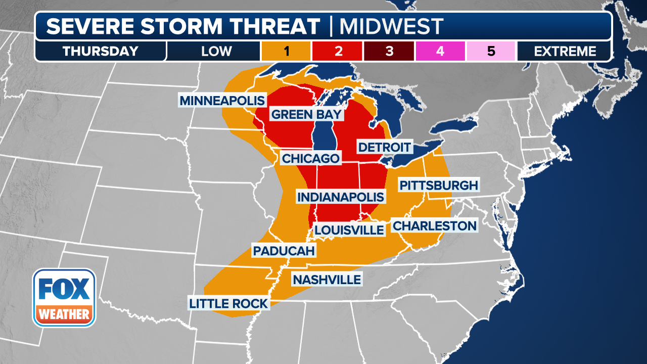
Thursday: Southeast coast under threat of severe weather
The strength and the timing of the low-pressure system keep the Thursday forecast in flux as well.
6 TYPES OF CLOUDS YOU MIGHT SEE DURING SEVERE STORMS
(FOX Weather)
It is likely that there will be severe storms as the area of low pressure continues moving north, but the severe weather ingredients could be weaker than earlier in the week, the FOX Forecast Center said.
As it stands now, severe storms appear most likely in North Carolina, South Carolina, Georgia and northern Florida, with again damaging winds and isolated tornadoes the main threats.