Strong winter storm spreading heavy snow, ice, flooding rain and high winds from Plains to Midwest, Northeast
Snow could fall at the rate of 1 to 2 inches per hour in parts of the Midwest on Thursday
Winter Storm Warning in effect until late Thursday night for Missouri, Illinois
A Winter Storm Warning will be active until 9 PM central time for Missouri and Illinois Thursday evening.
FOX Weather is live with the Weather Wire covering live updates on the massive winter storm impacting more than 119 million Americans across the country. Click the FOX Weather Wire for live updates.
A strong winter storm tracking across the central and eastern United States is bringing heavy snow, ice, flooding rain and high winds as it moves through the Plains, Midwest and Northeast.
The storm system is currently spreading snow, sleet, freezing rain and plain rain from eastern Kansas into the Midwest, southern Great Lakes and interior Northeast.
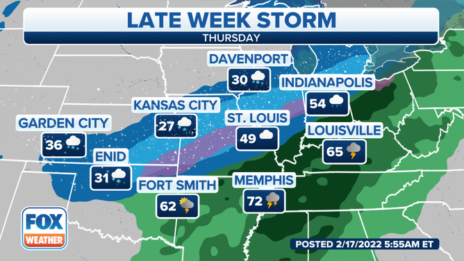
Thundersnow was reported in Kansas City, Missouri, early Thursday morning. FOX Weather Watcher C.T. Thongklin captured the moment it happened on video. Kansas City had picked up 6.4 inches of snow as of noon Central time, breaking the daily snowfall record of 6 inches set way back on Feb. 17, 1893. This is also the city's snowiest day since Feb. 4, 2014, when 7.5 inches fell.
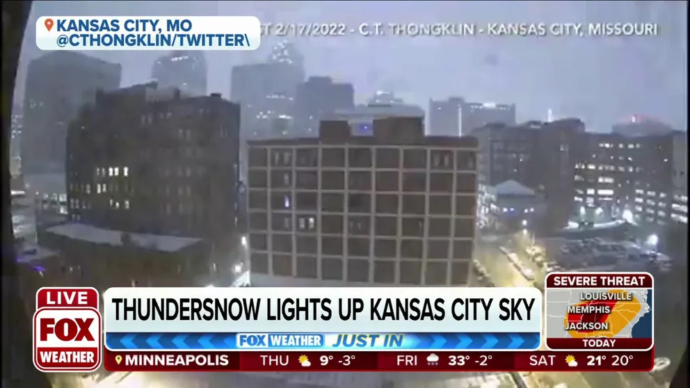
Thundersnow lights up Kansas City sky
Thundersnow lights up the Kansas City sky Thursday morning.
FROM THUNDERSNOW TO ICE, KANSAS CITY EXPERIENCES WEATHER BINGO DURING WINTER STORM
To the southwest of Kansas City, the Wichita, Kansas, metro area has reported up to 6 inches of snow with snowdrifts 12 to 18 inches high. Blizzard conditions were officially met in Wichita on Thursday morning.
On the storm's warm side, there have been numerous reports of flooding in the southern Great Lakes and Ohio Valley. Multiple high-water and swift-water rescues were required in Vermilion, Ohio, late Thursday morning after an ice jam caused the Vermilion River to flood.
The National Weather Service has issued Winter Storm Warnings and Winter Weather Advisories from portions of Oklahoma to the southern Great Lakes, upstate New York and far northern New England.
These winter weather alerts include the cities of Kansas City, St. Louis, Chicago, Detroit and Buffalo, New York.
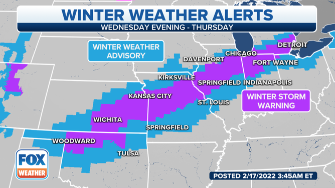
Winter Storm Warnings and Winter Weather Advisories are in effect on Thursday, Feb. 17, 2022.
(FOX Weather)
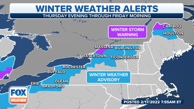
Winter Weather Advisories and Winter Storm Warnings are in effect through Friday morning, Feb. 18, 2022.
(FOX Weather)
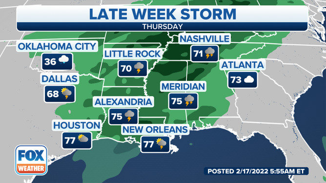
There's also a threat of severe thunderstorms, including tornadoes, on the warmer side of the storm system through Thursday evening in parts of the South. Be sure to download the FOX Weather app for the latest forecast and weather alerts for your exact location, plus our channel's 24/7 livestream.
SEVERE STORMS PACKING DAMAGING WINDS, TORNADOES THREATEN SOUTH ON THURSDAY
Timing the snow, ice and rain
Thursday-Thursday night
Snow is likely on Thursday from eastern Kansas into parts of Missouri, Illinois, northern Indiana, northern Ohio and Lower Michigan.
NOAA's Storm Prediction Center said the snow could fall at the rate of 1 to 2 inches per hour in portions of the Midwest.
WHY SNOWFALL RATE IS IMPORTANT TO UNDERSTANDING WINTER WEATHER
Forecast for Thursday, Feb. 17, 2022.
(FOX Weather)
Meanwhile, a soaking rain will drench areas from the Deep South into the Ohio Valley and interior Northeast on Thursday. The rain might be heavy enough in some spots to result in localized flash flooding.
According to NOAA's Weather Prediction Center, the greatest risk of flash flooding through Thursday night stretches from portions of the mid-Mississippi and Ohio valleys to western Pennsylvania, upstate New York and Vermont.
Forecast for Thursday, Feb. 17, 2022.
(FOX Weather)
High winds are also expected over a large portion of the South, Midwest and Northeast. In parts of the Central Plains and Midwest where snow is falling, that could result in blowing and drifting snow with low visibility. This would make driving conditions even more dangerous than they already would be from the snow alone.
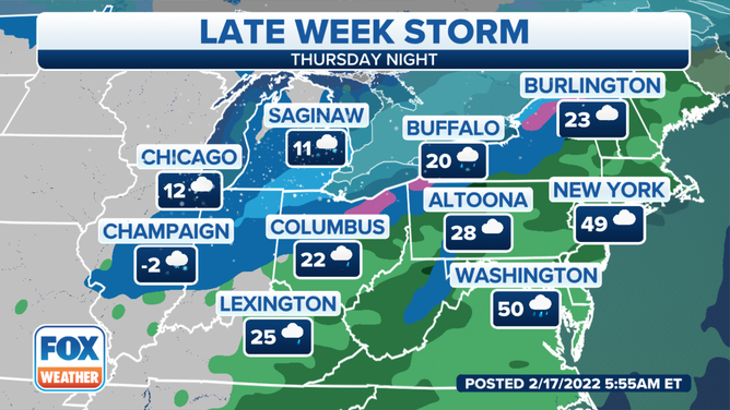
The rain and gusty winds will reach the East Coast Thursday night, including the Boston-to-Washington Interstate 95 corridor.
Enough cold air might arrive overnight for the rain to change over to a period of snow or ice in portions of the Ohio Valley, interior Northeast and northern New England. However, areas near Interstate 95 will likely stay warm enough for all rain.
Forecast for Thursday night, Feb. 17, 2022.
(FOX Weather)
Friday
Rain will continue along the East Coast into early Friday morning before the storm pushes off the Eastern Seaboard later in the morning.
Some lingering snow is also possible in the interior Northeast and northern New England on Friday morning.
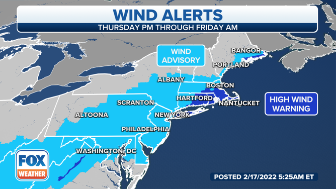
However, strong, damaging winds will impact portions of the Northeast coast Thursday night into Friday morning.
High Wind Warnings have been issued by the NWS for parts of New England and Long Island due to the potential for gusts up to 65 mph. Winds of that magnitude can cause tree damage and power outages. The highest risk of widespread power outages and downed trees is from eastern and southeastern Massachusetts into Rhode Island.
STRONG, DAMAGING WINDS EXPECTED FROM THE GULF COAST INTO NEW ENGLAND THROUGH FRIDAY MORNING
Wind Advisories have also been posted for many other areas of the Northeast and mid-Atlantic, where gusts up to 50 mph are possible. That could trigger a few power outages and break some tree limbs.
Wind alerts are in effect across the mid-Atlantic and Northeast.
(FOX Weather)
Snow, ice and rain forecast
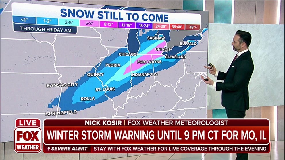
A narrow band of 6-plus-inch snow totals is predicted from parts of eastern Kansas to southeastern Lower Michigan, the St. Lawrence Valley of upstate New York and far northern Maine. Up to a foot of snow is not ruled out in some of those areas in the Midwest.
There will likely be a very sharp cutoff in snowfall totals north and south of that heavier narrow band.
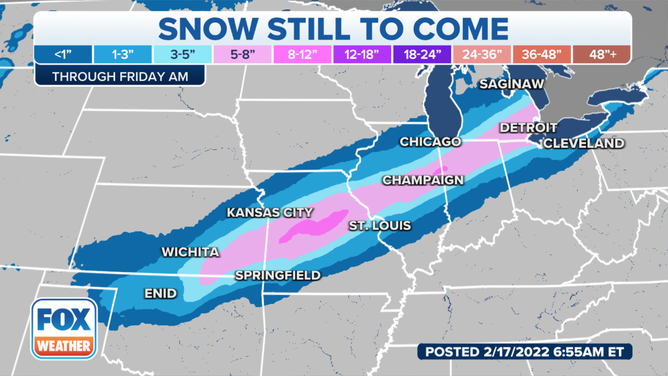
Snow forecast through Friday morning, Feb. 18, 2022.
(FOX Weather)
There could also be some light ice accretion from portions of the mid-Mississippi Valley into the eastern Great Lakes. That would cause any untreated roads, especially bridges and overpasses, to become slippery.
Localized tree damage and scattered power outages are also possible in the areas shaded in a lighter pink on the map below, but we do not expect a widespread, disruptive ice storm in this region.
HOW MUCH ICE IS NEEDED TO KNOCK OUT POWER, DAMAGE TREES?
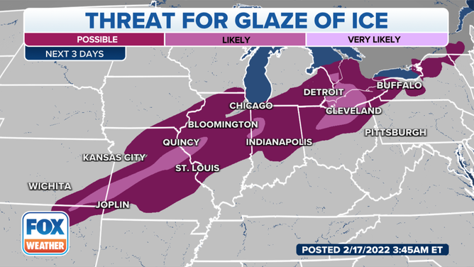
Threat for a glaze of ice in the Midwest and interior Northeast.
(FOX Weather)
On the warm side of this storm, at least an inch of rain is expected over a broad area from the Deep South to the Ohio Valley, southern Great Lakes and parts of the interior Northeast.
Locally higher rainfall totals between 2 and 3 inches are possible in some locations, particularly in the Ohio Valley.
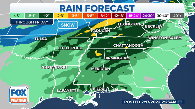
Rain forecast through Friday, Feb. 18, 2022.
(FOX Weather)
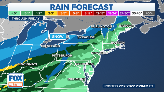
Rain forecast through Friday, Feb. 18, 2022.
(FOX Weather)
The rain could lead to flooding in parts of those regions.
As a result, Flood Watches have been hoisted by the NWS from southern and eastern Missouri to the Ohio Valley, southern Great Lakes, northern Pennsylvania, upstate New York and Vermont.
EXPLAINING FLOOD ALERTS ISSUED BY THE NATIONAL WEATHER SERVICE
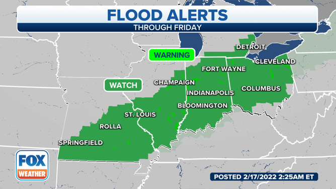
Flood Watches are in effect through Friday, Feb. 18, 2022.
(FOX Weather)
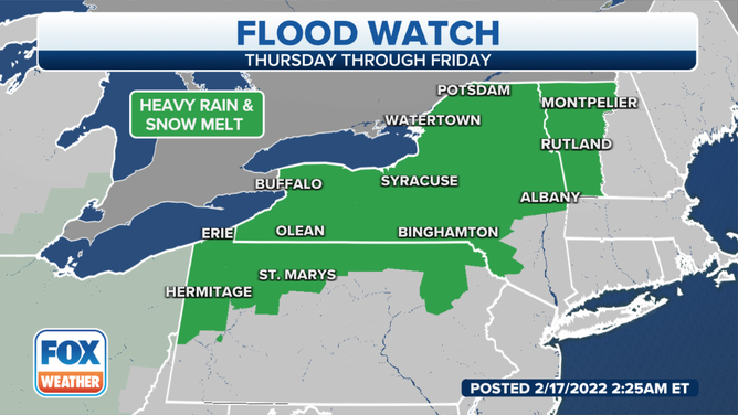
Flood Watches are in effect through Friday, Feb. 18, 2022.
(FOX Weather)
In addition, ice jams are a concern on rivers in the southern Great Lakes and interior Northeast due to warmer temperatures ahead of the storm followed by locally heavy rainfall when the storm arrives.
WHAT IS AN ICE JAM AND ARE THEY DANGEROUS?
Winter storm recap
On Tuesday, the winter storm brought a few inches of snow to California's Sierra Nevada, as well as reports of thundersnow at Lake Arrowhead in the mountains of Southern California. Showers and thunderstorms associated with this system also produced small hail in the lower elevations of Southern California.
OH, HAIL NO! STRONG STORMS DUMP HAIL ON PARTS OF SOUTHERN CALIFORNIA
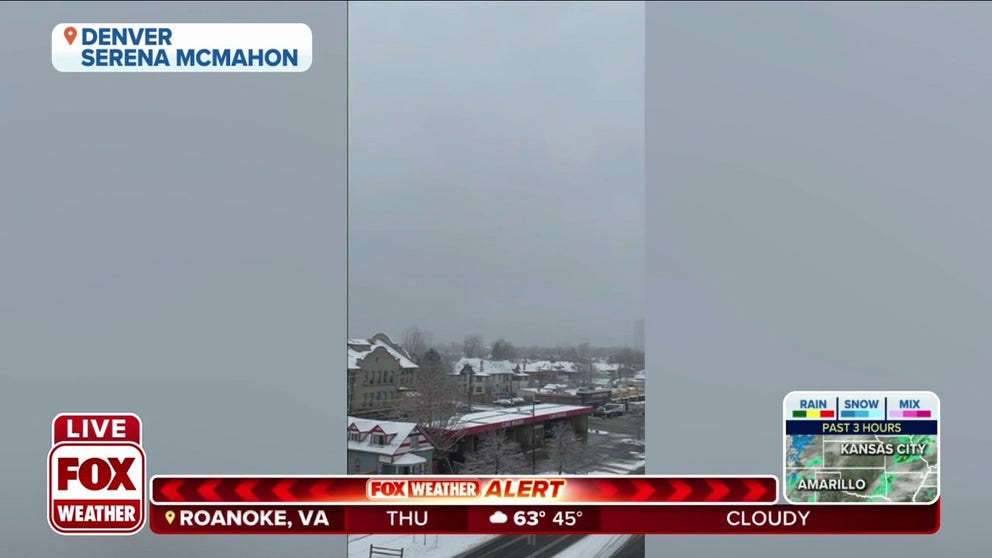
Snowflakes fall in Denver on Wednesday
Snowflakes were seen falling in Denver. Some areas of the Mile High City picked up several inches of snow Wednesday.
The Denver metro area then picked up 3 to 6 inches of snow Wednesday into Wednesday night as the storm dropped south and eastward through the Rockies. The higher elevations west of Denver received up to 8.8 inches.