WEATHER WIRE: Winter storm produces foot of snow, tornadoes
WEATHER WIRE: Winter storm produces foot of snow, tornadoes
Download the AppCoverage for this event has ended.
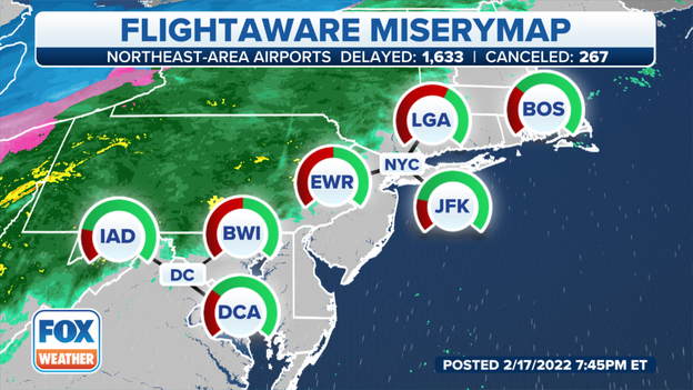
Airport delay map
FlightAware reports more than 1,300 flights were canceled on Thursday and the travel headaches are expected to linger into Friday.
At least 200 flights, many from the Midwest and Northeast, have been canceled for Friday.
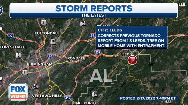
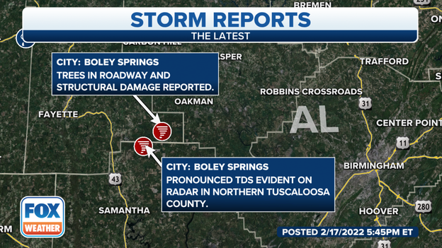
Damage reported in Alabama
Law enforcement reported people were trapped in a mobile home southeast of Birmingham, AL after the tornado warned storm moved through the area.
What we're learning about the damage: Click Here
Video captured a funnel cloud moving over Highway 45 in eastern Mississippi.
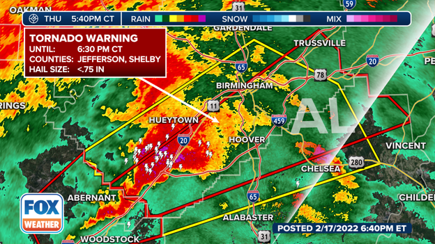
Tornado Warning for metro Birmingham
The National Weather Service has issued a Tornado Warning for Shelby and Jefferson counties in Alabama until 6:30 P.M. CDT. The warning includes part of the city of Birmingham. Meteorologists said the storm had rotation and so far the tornado is only radar indicated.
Rotation north of Birmingham, AL
Meteorologists say rotation in a storm in northern Jefferson County continues. The National Weather Services advises everyone in the towns of Adamsville, Gardendale, and Pinson to seek shelter.
Updated forecast: Click Here
Initial damage reports
Several trees and homes were damaged by what meteorologists believe was a likely tornado north of the city of Tuscaloosa on Thursday afternoon. PowerOutage.US reported more than 5,000 residents were without power statewide. So far, no word on if there were any injuries.
First responders say several highways in central Illinois are impassible due ice, snow and crashes. I-39 is closed around El Paso, IL; I-74 is closed near Leroy; IL; and major a major crash was reported along I-55 near Towanda, IL.
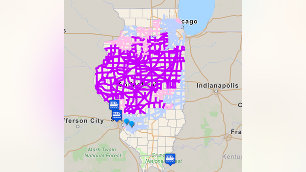
Illinois roadway condition map
Blue roadways: Blowing snow and or areas of icing
Pink roadways: Scattered snow-covered roads due to blowing snow
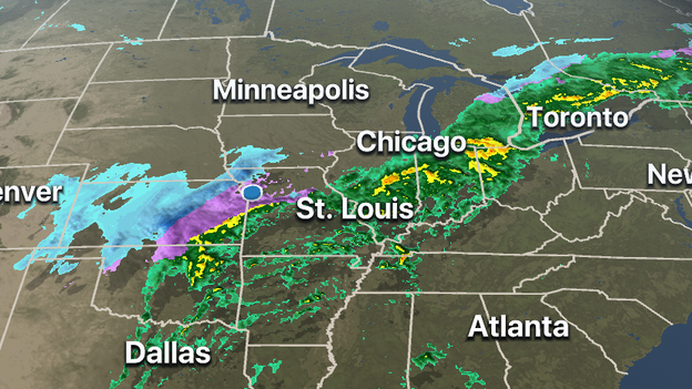
FOX Weather 3D Radar
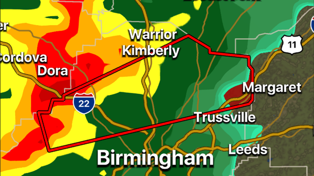
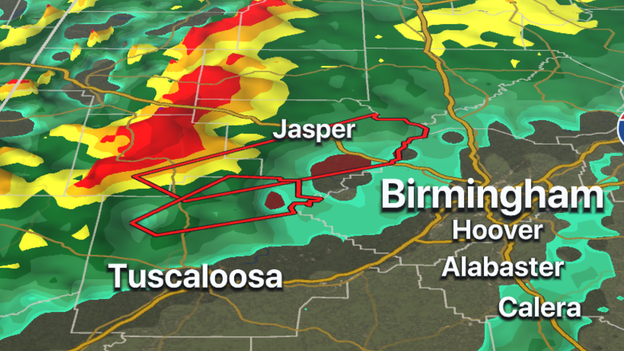
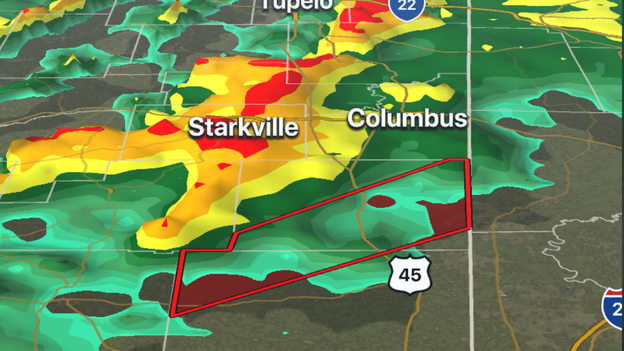
The National Weather Service has issued a Tornado Warning for Walker, Tuscaloosa and Fayette counties in Alabama. Meteorologists consider the rotation "large and extremely dangerous." Cities in the path of the tornado include: Jasper, Sumiton, Cordova, Dora, Berry, Parrish, Oakman, Sipsey, Gorgas Steam Plant, Gorgas, Boley Springs, Rocky Hollow, Burnwell, Beloit, Quinton, Lynns Park, Whitson, Empire, West Corona and Powellville.
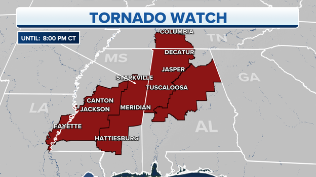
Tornado Watch Expanded
A Tornado Watch now includes much of central Alabama including the city of Birmingham. The watch extends until 8 p.m. CDT.
Updated forecast: Click Here
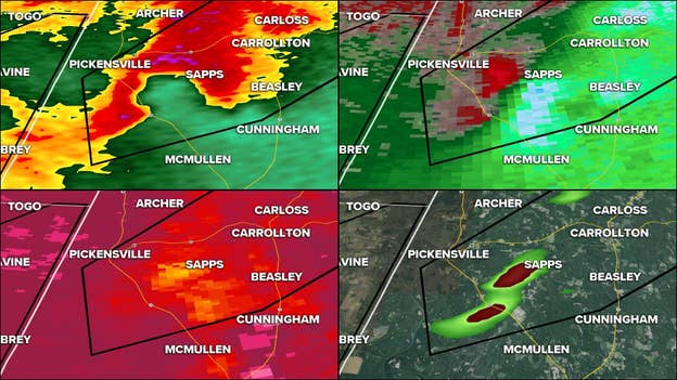
Possible debris detected on radar
Radar detected possible debris with the tornado-warned storm that moved through western Alabama on Thursday afternoon. The National Weather Service has not confirmed a tornado touched down but meteorologists could use the info from radar in determining where to send crews to investigate for possible damage.
Latest forecast: Click Here
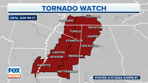
Tornado Watch is set to expire at 8 p.m. CDT
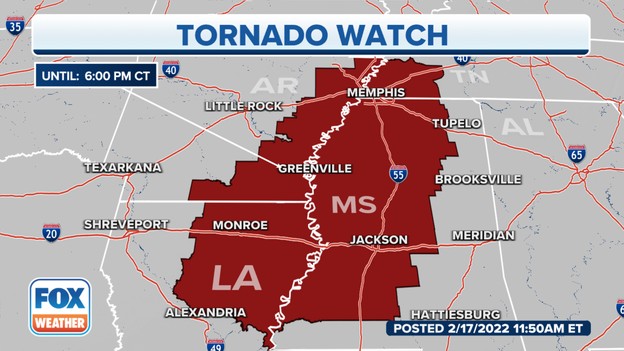
Around 3.8 million people are under a Tornado Watch that stretches from Louisiana to Tennessee. A watch means conditions are favorable for a tornado forming in and close to the alerted area.
Learn about the difference between a watch and a warning: Click Here
Tornado Warning for Noxubee and Kemper counties in Mississippi
The National Weather Service is tracking a storm with rotation near Shuqualak, Mississippi. Both Noxubee and Kemper counties in Mississippi are under a Tornado Warning until 3:45 PM CST.
Download the FOX Weather app: Click Here
The tornado warning for north Mississippi has been canceled. A tornado watch continues until 8 p.m. CT. for the following counties:
ALCORN
ITAWAMBA
LEE
MONROE
PRENTISS
TISHOMINGO
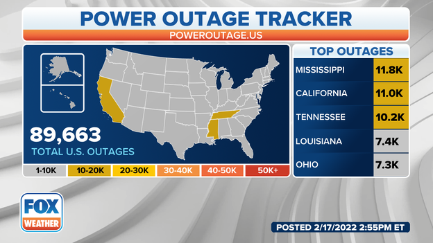
Power outages across the U.S.
Power outages are rising as a severe weather continues in Mississippi and Tennessee.
A Tornado Watch has been issued until 9 p.m. for portions of Alabama, Mississippi and Tennessee.
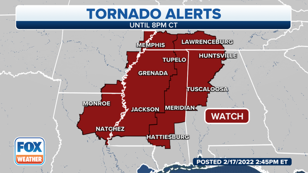
A tornado watch is in effect until 8 p.m. Central
5 states are now included in a new tornado watch.
The watch is in effect for parts of Louisiana, Arkansas, Kentucky, Mississippi and Alabama until 8 p.m. Central.
For more information about the severe weather, click here.
The National Weather Service has issued a tornado warning for the communities of Canton, Thomastown and Camden, Mississippi, until 2:30 p.m. local time.
The tornado is radar indicated and is moving to the northeast at 45 mph.
For more information on the severe weather, click here.
Watch live video of new severe weather alerts as they're added into the FOX Weather alert system.
For more information on the severe weather, click here.
A tornado warning is in effect until 1:45 p.m. local time
For more information about the severe weather, click here.
The Kansas Highway Patrol said the roads are treacherous, icy and snow-packed.
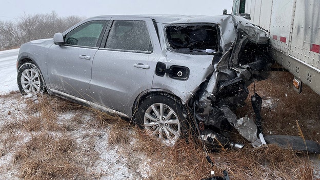
(Kansas Highway Patrol)
This is one of their trooper’s vehicles after he was struck by a semi on eastbound Interstate 70 near mile-marker346 in Shawnee County.
The trooper is OK, the patrol said.
"We urge you to stay home. If you must be out then slow down and don’t overdrive your skills in snow and ice," the patrol said in a tweet.
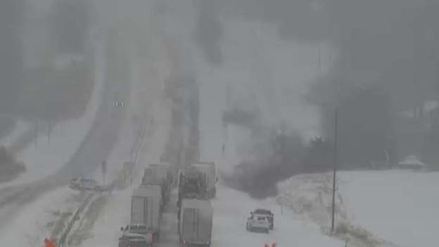
(MoDOT Central District)
The Missouri Department of Transportation said all westbound lanes of Interstate 70 are closed near mile marker 124 just west of Stadium Boulevard in Columbia due to a tractor-trailer crash.
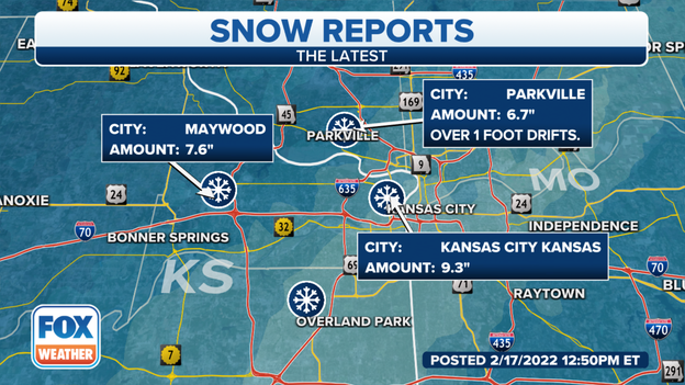
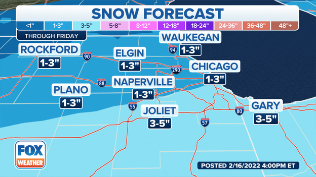
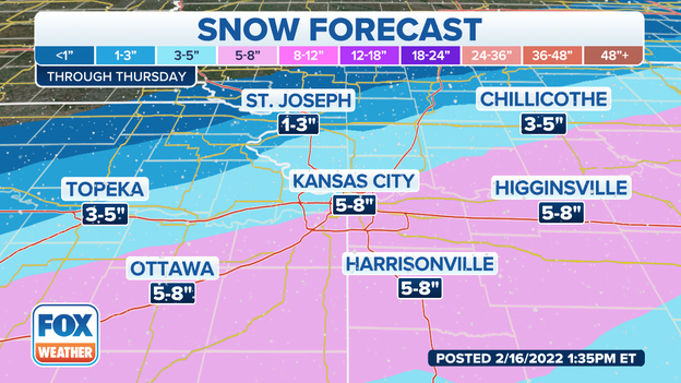
Snow totals so far
Snow totals keep rising.
Kansas City, Kansas, has picked up more than 9 inches of snow from this major storm system moving through the region.
For more information about the storm, click here.
Little Rock Mayor Frank Scott Jr. spoke to FOX Weather about on how his city is doing so far on Thursday. Heavy rain is coming down in Arkansas where some areas are under a Flash Flood Warning.

Snow totals so far
Parts of Kansas have already picked up more than 7 inches of snow.
Here's a look at the snow totals so far.
For more information about the storm, click here.
(FOX Weather)
A Tornado Watch has been issued for parts of Arkansas, Louisiana, Mississippi and Tennessee until 6 p.m. Central.
The National Weather Service in Chicago has issued a Flash Flood Warning for a break-up ice jam on the Kankakee River near Wilmington.
The NWS said significant river rises are occurring near the Interstate 55 bridge.
"If the ice jam breaks, areas downstream of I-55 could be impacted by flooding with little notice," the NWS said in a tweet.
(FOX Weather)
The National Weather Service in Lincoln, Illinois, said wintry weather has begun to spread into west-central Illinois.
Heavy snow will begin late Thursday morning for locations generally along and north of Interstate 72 with sleet and freezing rain continuing toward the south.
FOX Weather Watch Derrick Snyder said flooding is already getting pretty noticeable in Paducah, Kentucky, with only 1 inch of rain so far.
Make sure to follow FOX Weather on social media for more videos, photos and coverage of the winter storm. Don't forget to tag us in your weather photos or use #FOXWeather.
FOX Weather on Facebook: facebook.com/FOXWeather
FOX Weather on Twitter: twitter.com/FOXWeather
FOX Weather on Instagram: instagram.com/FOXWeather
FOX Weather on TikTok: tiktok.com/@officialfoxweather
FOX Weather on YouTube: youtube.com/foxweather
(FOX Weather)
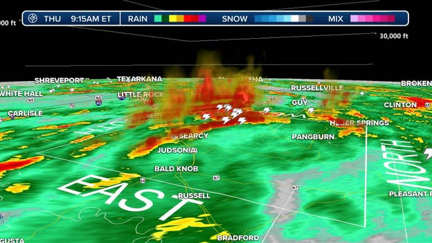
FOX Weather Meteorologist Jordan Overton said he is starting to see updrafts get up to about 30,000 feet on some of Arkansas storm cells.
"They might be trying to tap into pockets of surface instability that is developing over the area. Right now they are elevated, but if storms are able to root, could start seeing a few severe warnings," Overton said.
(FOX Weather)
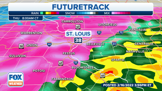
The National Weather Service in St. Louis said the transition to snow is quickly occurring now in western Illinois near Quincy.
Click on the image above to watch video.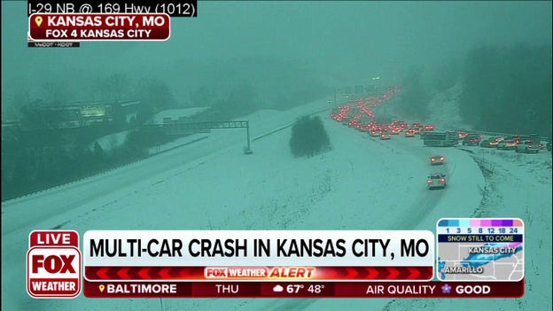
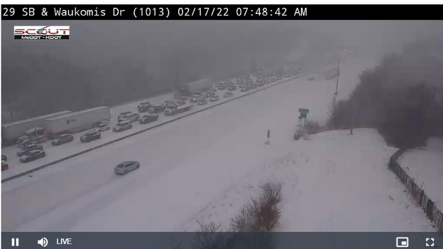
A major winter storm has caused a multi-car crash in Kansas City, Missouri, on Thursday morning.
FOX Weather Watcher Brian Ellison captures intense snow falling Thursday morning in Kansas City, Missouri.
The National Weather Service in Kansas City said near-whiteout conditions could be possible at times.
Make sure to follow FOX Weather on social media for more videos, photos and coverage of the winter storm. Don't forget to tag us in your weather photos or use #FOXWeather.
FOX Weather on Facebook: facebook.com/FOXWeather
FOX Weather on Twitter: twitter.com/FOXWeather
FOX Weather on Instagram: instagram.com/FOXWeather
FOX Weather on TikTok: tiktok.com/@officialfoxweather
FOX Weather on YouTube: youtube.com/foxweather
Most people associate thunder and lightning with thunderstorms, but you shouldn't be surprised if you hear a rumble or two coming from the sky during heavy snowfall.
While thundersnow is a rare phenomenon, it can happen. Click here to read more.
(FOX Weather)
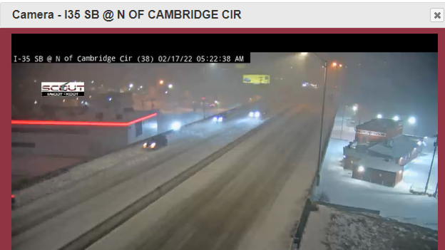
The National Weather Service said Kansas City picked up 1.8 inches of snow as of 6 a.m. Thursday. Snow rate of 1-2 inches per hour will be possible through the morning hours.
A Flash Flood Warning has been posted until 1 p.m. for areas including Monticello and Norway, Indiana, until 1 p.m. Eastern.
Rain changes to a wintry mix and then snow today from northwest to southeast. Slushy and slippery conditions are expected for the evening commute, especially for areas north of U.S. Highway 24 with moderate to heavy snow expected.
(NWS Kansas City)
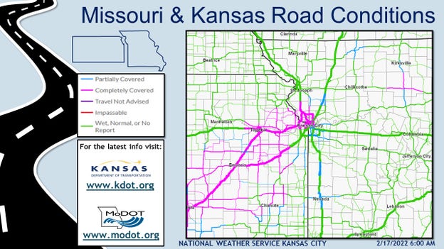
Transportation departments in Kansas and Missouri are reminding drivers to take it slow this morning, and stay home if possible to allow snowplow drivers room to work.
(FOX Weather)
Use your FOX Weather app to monitor the storms and receive alerts.
Apple App Store download: Click here
Google Play Store download: Click here
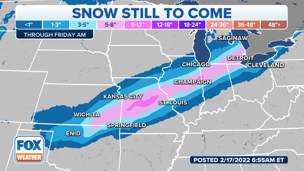
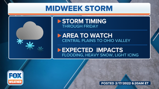
Every single state in the entire eastern half of the nation is going to be affected in some way by this massive storm.
(FOX Weatheer)
(Missouri Department of Transportation)
Intense snow is starting to fall across the Kansas City metro. The National Weather Service said thundersnow reported about 5 a.m. Thursday at Charles B. Wheeler Downtown Airport.
Road conditions will deteriorate quickly, the NWS said.
Click on the image above to watch video.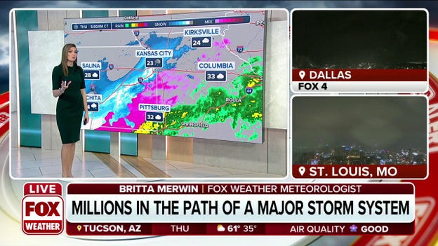
Millions are in the path of a major storm system producing severe storms and snow.
You’ve reached the beginning of this live coverage.