Coldest air of season sweeps across eastern US, spreading freeze alerts to Florida
The coldest air so far this season is being felt by millions of Americans on Wednesday.
Coldest air of season sweeps across eastern US, spreading freeze alerts to Florida
Wednesday morning will again feature very impressive cold for mid-October. Over 50 low temperature records are expected to fall across the Southeast, Texas and the Missouri Valley.
The coldest air so far this fall has shattered dozens of records across the eastern half of the U.S. as millions of Americans face their first freeze of the season, including as far south as the Gulf Coast and the Florida Panhandle.
A cold, Canadian high-pressure system being tracked by the FOX Forecast Center is responsible for ushering in the widespread chilly air mass, which will continue to dominate the weather across the Midwest, South and East until a pattern change begins to take shape late in the week.
This early-season cold snap will provide the lowest temperatures since April in many areas. Most locations from the central and southern Plains to the Gulf and East coasts are expected to see temperatures between 15 and 30 degrees below average through Thursday morning.
The cold air started to move into the country out of Canada on Monday and has been expanding its reach farther south and eastward over the last couple of days.

(FOX Weather)
"Part of the reason why this is happening is because we have a dip in the jet stream," FOX Weather meteorologist Jason Frazer said. "That is essentially allowing all of that cold, Canadian air to sneak down."
A lake-effect snowstorm in the Upper Peninsula of Michigan and northern Wisconsin has also resulted from this blast of chilly air.
As of Wednesday morning, up to 18 inches of snow had been reported near Marquette and National Mine, Michigan, as well as in Gile, Wisconsin. The 18-inch total in Marquette set a record for its greatest two-day snowfall in the month of October.
How low will temperatures go?
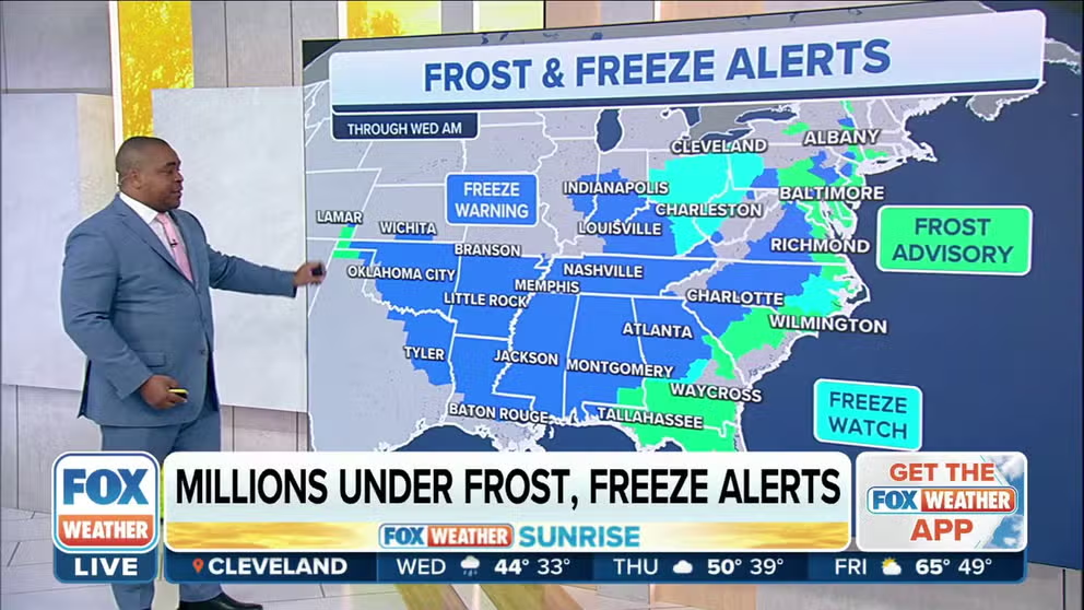
This cold air invasion has prompted the National Weather Service to issue Freeze Warnings and Frost Advisories for more than 60 million Americans from the central and southern Plains to the Gulf and East coasts.
According to the FOX Forecast Center, the annual growing season will likely end in many areas because of the likelihood of temperatures dropping to near or below 32 degrees in the locations covered by Freeze Warnings. This includes cities as far south as Atlanta, Mobile in Alabama and Baton Rouge in Louisiana.
"Make sure that if you have any plants or any pets outdoors that are sensitive to the cold, that you either cover them up or bring them inside," Frazer said.

(FOX Weather)
The cold air mass will provide morning low temperatures and afternoon highs that are much colder than average across the South and East.
Birmingham, Alabama, saw its first freeze of the season shortly before sunrise Wednesday as lows dipped to 32 degrees.
Even the northern half of Florida had widespread temperatures in the 30s Wednesday morning, which was significantly colder than the lower 60s at the same time in northern Maine, where the cold front had yet to push through.
Dozens of record lows were tied or broken both Tuesday and Wednesday mornings as the frigid air expanded its reach. A notable record low was set Tuesday morning in Kansas City, Missouri, which dipped to 25 degrees and broke its previous record low for Oct. 18 of 28 degrees set in 1972. A low of 25 degrees is more typical of mid-December than mid-October.
The FOX Forecast Center expects millions of people from the Canadian border to the northern Gulf Coast will experience near- or below-freezing temperatures again Thursday morning, including as far south as Alabama and Georgia.
HERE'S WHEN TO EXPECT THE FIRST FREEZE OF THE SEASON
Along the Interstate 95 corridor in the Northeast, low temperatures will generally remain above freezing, but there could still be areas of frost the next couple of mornings as lows fall into the mid- to upper 30s with a light wind in cities such as Philadelphia and Baltimore.
It will be several degrees colder in the interior Northeast and northern New England, where near- or below-freezing temperatures are expected Thursday and Friday mornings, though many locations in those areas have already dipped to 32 this season.

(FOX Weather)
Dozens more records in jeopardy of falling
The cold temperatures will place more than two dozen additional record lows in jeopardy Thursday morning from the Ohio Valley to the Southeast.
Atlanta's daily record low of 34 degrees Wednesday will be in jeopardy, as will the 32-degree record in Montgomery, Alabama, and Knoxville, Tennessee's record low of 31 degrees.

(FOX Weather)
Meanwhile, afternoon high temperatures will be stuck in the 40s from parts of the Upper Midwest to the interior Northeast for the next couple of days.
While not as cold, highs will still be chilly across the rest of the Midwest and East, with temperatures remaining in the 50s from the Interstate 95 corridor in the Northeast into parts of the Southeast.
Wednesday's highs will be rather chilly for Florida standards, where temperatures will only top out in the upper 60s to mid-70s. Nearly every weather station in the Sunshine State will be flirting with its daily record-cold high for Oct. 19.
Fort Myers, Florida, will struggle to even reach 70 degrees Wednesday. This Southwest Florida city has failed to reach 70 degrees in October only 11 times since 1892.
GULF COAST STATES FOUND TO BE AMONG MOST VULNERABLE TO BILLION-DOLLAR DISASTERS

(FOX Weather)
"I think it's going to be even a larger impact for folks down South – of course, we're feeling the big chill up North – but down South, this is really the first taste of cold air, and with temperatures so far below average, you are really going to take notice," FOX Weather meteorologist Britta Merwin said.
If you're not quite ready for the fall chill this early in the season, you're in luck. A pattern change setting up across the U.S. is expected to take shape by this weekend, sending temperatures back above average for most areas east of the Rockies.
FALL FLIP-FLOP: WEST TO GET FIRST SIGNIFICANT RAIN IN MONTHS AS EAST SHAKES THE AUTUMN CHILL
The latest 6- to 10-day temperature outlook from NOAA's Climate Prediction Center highlights the Northeast as having the highest likelihood of warmer-than-average temperatures next week, but above-average warmth is expected to dominate from the Mississippi Valley to the Gulf and East coasts.
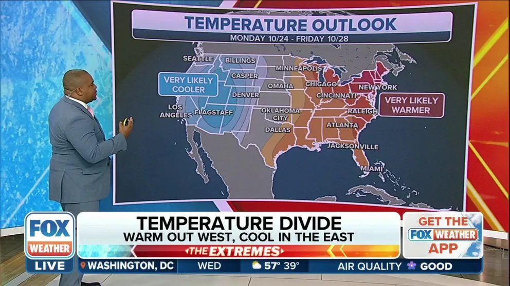
Temperature Divide: Eastern half of country to warm up, while West to cool down next week
After this record-cold week in much of the eastern half of the nation, temperatures will climb to levels that are 10 to 20 degrees above-average this weekend and into early next week, while the West will start to see a cool down.