Nor'easter prompts winter storm alerts for millions from North Carolina to Maine
Snowfall amounts have trended down in the past 24 hours in the mid-Atlantic and Northeast, but parts of the Interstate 95 corridor could still pick up at least an inch of snow.
Interior Northeast, New England brace for heavy snow
FOX Weather winter storm specialist Tom Niziol said while some major cities will miss out on the snowfall others are set to see quite the storm.
Editor's note: This story is no longer being updated. Click here to view our new story that has continuing coverage of the nor'easter.
NEW YORK – A developing storm that is expected to become the inaugural nor'easter of 2024 could bring the first significant snow in two years for several cities along the East Coast and flooding rain for the South, all translating to messy weekend travel across the eastern U.S.
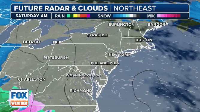
The storm is organizing Friday along the Gulf Coast. While computer forecast models still vary widely on snow and rain amounts, the entire Eastern Seaboard will experience gusty winds and precipitation.
Millions of residents from the Carolinas to Maine are under a winter weather alerts ahead of the arrival of the worst weather. New York City, Philadelphia and Washington, D.C. sit just outside warned areas but could see an occasional mix of precipitation as temperatures flirt with the freezing mark.
WEEKEND NOR'EASTER LIVE TRACKER: LATEST FORECAST, LIVE RADAR, SNOWFALL TOTALS AND MORE

(FOX Weather)
Winter storm timeline
Saturday
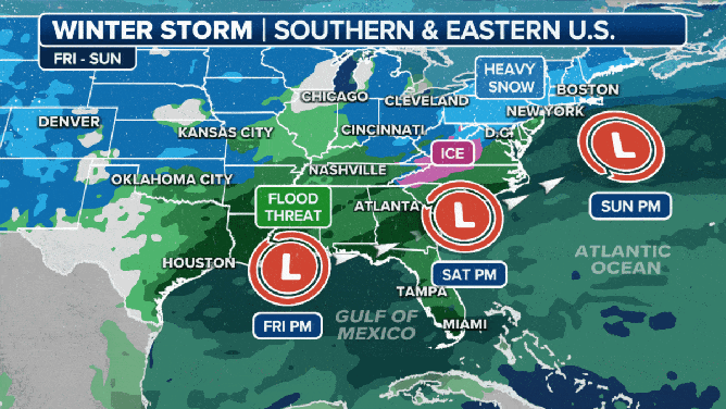
On Saturday, the low-pressure system is forecast to plow east and northeastward as it organizes and strengthens along the Eastern Seaboard.
On its northern end, snow will quickly break out across the Ohio Valley and central Appalachians. Several inches of snow appear likely at this time. Warm air moving over cold air trapped near the surface may allow for freezing rain to fall across the Blue Ridge Mountains of North Carolina and Virginia.
The exclusive FOX Model Futuretrack of the approaching nor'easter this weekend.
(FOX Weather)
Sunday
The storm is predicted to move just off the East Coast near the Carolinas and continue to head northward, skirting the New England coast on Sunday.
Heavy snow and gusty winds will linger Sunday morning in parts of New York, Pennsylvania, New England, New Jersey and the higher elevations of the central Appalachians.
"As we get into Sunday morning and the system gets up through Cape Cod, a strong easterly flow of a lot of moisture coming off of the ocean is going to impact southern New England. That is going to be just cold enough to produce heavy, wet snowfall. And that, combined with strong winds, could lead to some power outages, especially across parts of Massachusetts and going into southern New Hampshire, southern Maine," said FOX Weather winter storm specialist Tom Niziol.
WHEN IS THE FIRST SNOW OF THE SEASON?

(FOX Weather)
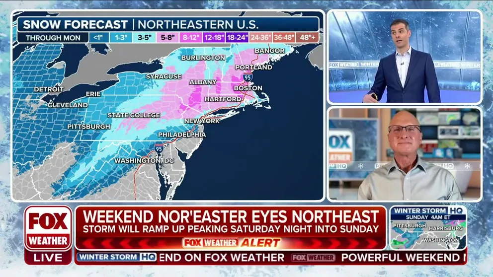
Where the snow and ice will be the heaviest
The FOX Forecast Center expects the snowfall to be heaviest in the higher elevations and communities west of Interstate 95 from the southern Appalachians through the U.S.-Canada border.
By the time the storm system moves away from the U.S. on Sunday, many locations will have received upwards of 4 inches of snow, with some locales picking up between 4 and 12 inches of new snow.
There are some communities outside of Boston that could see more than a foot of snow, but that could change as more computer data is received.

(FOX Weather)
Due to the Atlantic Ocean's modification of the airmass, the heaviest snowfall totals are expected to fall well away from large cities such as Washington, D.C., Philadelphia and New York.
"From New York down to Philly, you're not going to have any real big issues with snowfall. It's going to be warm enough for mainly a rain event," Niziol stated.
WHAT ARE THE WORST AIRPORTS TO FLY INTO DURING WINTER?

(FOX Weather)
Still, forecast models show the New York tri-state area receiving upwards of 3" of snow through Sunday morning.
WHEN IS THE FIRST SNOW OF THE SEASON?

(FOX Weather)
The FOX Forecast Center said there is also a growing threat of freezing rain in the central and southern Appalachians. Parts of southwestern Virginia, western North Carolina, upstate South Carolina and northeastern Georgia could see significant icing, putting a slippery glaze on pavement and weighing down tree limbs and power lines.
"The ice storm, though, a lot of confidence is growing on this part of the forecast," Merwin said. "We know we’re going to have a sneaky warm layer locked up in this storm and freezing temperatures on the ground. It’s raising red flags across the board."

(FOX Weather)
Preparations should be made for those living in working in the higher elevations of the Blue Ridge and Appalachian mountains in the mid-Atlantic as concerns for some minor ice accretions in those areas.
Most locations will pick up less than 0.10 inches of ice, but some areas could see more.
The highest risk of ice accretions of 0.10-0.25 inches exists in western North Carolina and Virginia. Communities such as Asheville, Greensboro and Mount Airy in North Carolina and Pulaski, Roanoke and Staunton in Virginia can expect to see more ice.
"A quarter of an inch of ice is nothing to scoff at or joke about," Merwin continued. "You want to make sure you’re prepared."
When was the last notable snowstorm for I-95 corridor?
Snow lovers should feel hopeful about the weekend, even several days out, because the current storm track is promising. We have to look back to late January 2022 to find the last notable snowstorm on the I-95 corridor. On Jan. 28-29, 2022, a nor'easter buried parts of the region under snow and even touched off blizzard conditions.
The 2024 storm will develop off the Gulf Coast and track offshore around the Carolinas. The 2022 nor'easter developed in the Atlantic off the Carolinas and traveled northward several hundred miles off the East Coast.
(FOX Weather)
Cold air in place in 2022 turned all precipitation into snow. Delaware and eastern New Jersey not only saw over a foot of snow, but winds gusting between 50 and 60 mph blew around the snow, turning the storm into a blizzard, according to the National Weather Service. Blizzard conditions pushed into New England on Jan. 29.
Boston measured 23.8 inches of snow. New York City saw 8.5 inches, while Baltimore got 1.5 inches.
BLIZZARD OF '22 PRODUCES HURRICANE-FORCE WINDS, DUMPS FEET OF SNOW IN NEW ENGLAND
Storm could end record snowless streaks for several cities along Eastern Seaboard
This nearly two-year streak without an inch of snow for Philadelphia smashed the previous record streak of 661 days without an inch of snow that ended in 1973. Long ago, New York City clobbered its old record of 383 days without an inch of snow that ended in 1998.
New York City only saw 2.3 inches of snow over the winter of 2022 through 2023. That is more than a 2-foot deficit compared to the average winter season snowfall and a record for the lowest annual snowfall total.
NEW YORK, PHILADELPHIA BREAKING RECORDS FOR LACK OF SNOW IN NORTHEAST
Philadelphia and Washington both saw less than a half-inch, leaving those cities with a 22.8-inch and 13.3-inch deficit, respectively. Even cities that saw snow got only a fraction of what they typically see. Boston saw 12.4 inches of snow over the 2022-23 winter, more than 3 feet less than average.

(FOX Weather)