The Daily Weather Update from FOX Weather: Northeast flash flooding turns deadly, could rival Hurricane Irene
Start your day with the latest weather news – Potentially catastrophic flash flooding looms for parts of the Northeast after historic rainfall turned deadly in New York's lower Hudson Valley on Sunday.
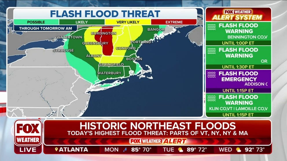
Nearly all of Vermont under extreme risk of flash flooding
Several inches of rain could lead to catastrophic flash flooding in Vermont on Monday with impacts that haven't been seen in the state since Hurricane Irene in 2011.
Welcome to the Daily Weather Update from FOX Weather. It’s Monday, July 10, 2023. Start your day the right way with everything you need to know about today's weather. You can also get a quick briefing of national, regional and local weather whenever you like with the FOX Weather Update podcast.
1 dead in Northeast flash flooding, which could rival 2011's Hurricane Irene on Monday
One person is dead after historic rainfall north of New York City triggered dozens of water rescues and led to roadways being washed out after more than a half-foot of rain fell in only a few hours Sunday.
The National Weather Service issued a Flash Flood Emergency for parts of Orange, Putnam, Rockland and Westchester counties in New York's lower Hudson Valley due to the life-threatening flooding.
The agency received reports of water rescues in Highland Falls, Fort Montgomery, Cornwall, West Point and several other communities in the lower Hudson Valley.
Orange County Officials confirmed to FOX Weather that a 30-year-old woman in Highland Falls was killed during the devastating flash flood.
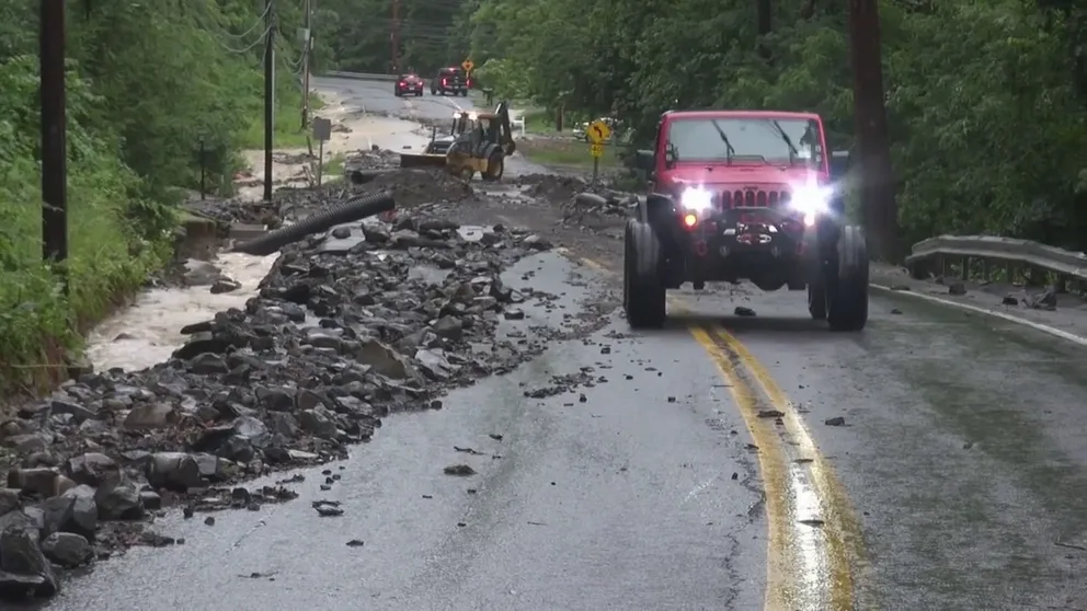
Watch: Floodwaters wash away roads in New York
Video recorded in Orange County, New York, shows rocks and debris covering roads after deadly and historic flooding on Sunday, July 9, 2023.
On Monday, the threat of potentially catastrophic flooding shifts north into New England. NOAA's Weather Prediction Center (WPC) has placed portions of Vermont and northeastern New York under a rare "high risk" of excessive rainfall – the first high risk issued for Vermont since August 2011 during Hurricane Irene.
When a high risk – the highest risk level that can be issued – is in place, it means severe, widespread flash floods are expected in the highlighted areas.
High risks are only issued on about 4% of days (including tropical and non-tropical events), but this risk category accounts for 39% of flood-related fatalities and 83% of flood-related damages in the continental U.S., according to research by WPC meteorologists.
"Expect significant to potentially catastrophic widespread flash flooding through Monday evening, with possible impacts not seen since (Hurricane) Irene," the National Weather Service office in Burlington, Vermont, wrote in a forecast discussion.
Irene produced a wide swath of 5 to 8 inches of rain across Vermont, which led to devastating mudslides and deadly flooding.

(FOX Weather)
Severe weather threat returns to Plains
While the Plains were largely spared from severe weather on Sunday, the break will be short-lived as the threat of storms is already back in the forecast.
Scattered severe thunderstorms packing threats of large hail and damaging winds are expected from parts of the Upper Midwest through the Plains on Monday.
(FOX Weather)
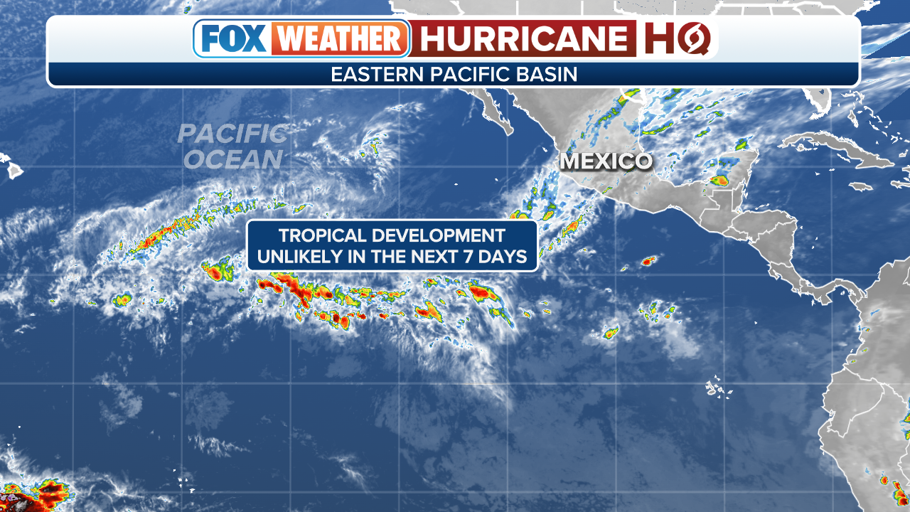
Hurricane HQ: What's happening in the tropics?
While a Saharan dust plume rolling off Africa and heading toward the Southeast U.S. is mostly keeping the Atlantic free of any tropical concerns, there is one spot that forecasters are keeping a close eye on.
The National Hurricane Center (NHC) has flagged an area of the central Atlantic Ocean where it believes an area of low pressure will form within the next couple of days a few hundred miles east-northeast of Bermuda.
For now, the NHC says that future area of low pressure has a low chance of acquiring some subtropical characteristics during the second half of this week as it drifts toward the southeast. By this weekend, however, that low is expected to turn northward, bringing the system over cooler waters and ending its chances of subtropical development.
Regardless of development, this system would not pose any threat to the U.S. East Coast.

(FOX Weather)
Over in the Eastern Pacific, the NHC has flagged two disturbances for possible development this week.
Computer forecast models show both disturbances working westbound over the open ocean.
The NHC says the second disturbance has a higher chance of development than Invest 93E. An invest is the designation the NHC uses to identify an area of disturbed weather being investigated for possible tropical development.
The next Eastern Pacific system that organizes into a tropical storm with winds of at least 40 mph will be named "Calvin."
(FOX Weather)
Bonus reads
Before you go, here are a couple of stories we think you might enjoy.
- Landslide forces evacuation of 12 homes south of Los Angeles
- NOAA forecast calls for half of world’s oceans to experience heat wave conditions this year
- Dangerous 110-plus-degree heat in Arizona likely to persist for weeks
Need more weather? Check your local forecast plus 3D radar in the FOX Weather app. You can also watch FOX Weather wherever you go using the FOX Weather app at foxweather.com/live or on your favorite streaming service.
You can share your weather pictures and videos with us anytime, anywhere, by emailing them to weather@fox.com or by adding the hashtag #FOXWeather to your post on your favorite social media platform.