Back-to-back storms eye central, eastern US with threats of severe weather, flooding, snow and ice
While the first storm will likely be more of a nuisance event, the second storm is expected to be much stronger and will bring the potential for a severe weather outbreak on Wednesday in parts of the South while heavy snow blasts portions of the Plains and Midwest.
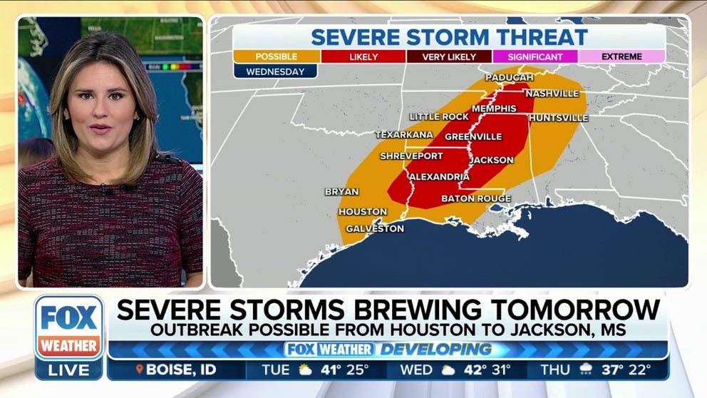
Another severe weather threat, including tornadoes, eyes South on Wednesday
Severe storms, with a potential severe weather outbreak, will be possible Wednesday afternoon and evening from Houston to Jackson, MS.
The FOX Forecast Center is tracking two separate storms that will lash the central and eastern U.S. this week, with threats of severe weather, flooding, snow and ice expected to impact millions of Americans.
While the first storm will likely be more of a nuisance event, the second storm is expected to be much stronger and will bring the potential for a severe weather outbreak on Wednesday in parts of the South while heavy snow blasts portions of the Plains and Midwest.

(FOX Weather)
Storm No. 1: Rain, snow sweep across parts of Midwest, East
The first storm got underway Monday morning when rain developed across the Midwest. The rain will gradually slide north and eastward throughout the day.
On the backside of this first storm, snow developed across the Dakotas and northern Minnesota. In general, only 1 to 3 inches of snowfall is expected, so very minimal travel impacts are expected in the region.
The leftovers of this system will move across the eastern U.S. on Tuesday, with rain showers expected for much of the East. However, the precipitation will likely begin as an icy wintry mix with freezing rain, sleet and snow across the higher terrain of Pennsylvania and upstate New York before changing to rain later Tuesday.

(FOX Weather)
Storm No. 2: Severe weather, flash flooding threats eye South, Ohio Valley
The second storm of the week will begin to develop Wednesday morning over the central Plains, and this one will have both severe weather and winter weather threats as it quickly races eastward, reaching the Northeast by Thursday.
Severe thunderstorms will be primarily focused across parts of the South, which is still reeling from an onslaught of two severe weather outbreaks so far this month. Once again, the FOX Forecast Center warned another severe weather outbreak is possible Wednesday, though the number of severe storms that may occur is still a bit uncertain.
This severe weather threat is expected to begin early Wednesday afternoon and continue throughout the afternoon and evening, as an unstable air mass develops from East Texas to southern Arkansas, northern and central Louisiana and western Mississippi. The combination of a cold front and a dryline – a boundary separating a humid air mass from a much drier, less humid air mass – will sweep eastward across these areas and provide the necessary trigger for severe thunderstorms to develop.
HERE'S WHERE TORNADOES ARE MOST LIKELY TO OCCUR IN JANUARY

(FOX Weather)
"As this storm system ejects out of the Rockies, we have that upper-air support … those stronger upper-level winds, and that's going to force up these thunderstorms along that boundary as this storm system gets going," FOX Weather meteorologist Jane Minar explained. "We are anticipating to see plenty of moisture, especially at the start of the day, and this is the key component in the forecast. When you have a lot of moisture getting pulled up from the Gulf of Mexico, it's what helps fuel the instability in the environment."
Any storms that develop closer to the cold front or dryline will be more capable of damaging wind gusts in excess of 60 mph, whereas storms that develop out ahead of the front in the so-called "warm sector" are likely to be supercell thunderstorms capable of tornadoes, in addition to damaging winds and large hail.
As the cold front moves eastward through Thursday, there is some indication that severe storms might persist farther east into the Ohio and Tennessee valleys and the Southeast, but confidence in Thursday's severe weather threat remains low at this time.
In addition to the severe thunderstorms, the FOX Forecast Center is monitoring the potential for flash flooding on Wednesday. This flash flood threat will stretch over a large area, from the Ohio Valley to the lower Mississippi Valley, and includes cities such as Cincinnati in Ohio, Louisville in Kentucky, Memphis in Tennessee, Little Rock in Arkansas and Shreveport in Louisiana.
Between 1 and 2 inches of rain is predicted to fall in those areas Wednesday, which, when combined with already-saturated soils, could lead to a significant threat of flash flooding.
7 FACTS YOU SHOULD KNOW ABOUT FLASH FLOODS

(FOX Weather)
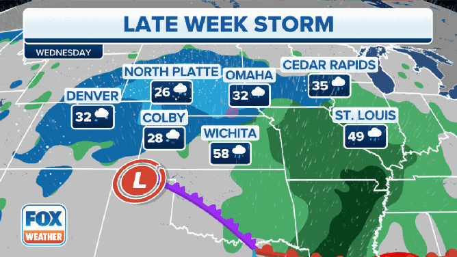
Storm No. 2: Heavy snow, gusty winds to spread across Plains, Midwest
On the wintry side of this storm, the FOX Forecast Center said a fairly impactful snow event is expected for parts of the central and northern Plains and the Upper Midwest. This is because the strength of the storm system should allow for intense snowfall rates, which increases confidence in the severity of the impacts.
A Winter Storm Warning has been issued by the National Weather Service from northeastern Colorado, including Denver, and far southeastern Wyoming eastward to parts of western Nebraska.

(FOX Weather)
Wednesday morning, an area of heavy snow will likely develop across the High Plains of northeastern Colorado, western and central Nebraska and northwestern Kansas. The snow could fall at the rate of an inch or more per hour, potentially leading to whiteout conditions at times. Gusty winds to 30-plus mph will also contribute to blowing snow and further contribute to the poor visibility.
Later Wednesday, the snow will expand eastward into southern South Dakota and the rest of Nebraska, then spread into the Upper Midwest overnight Wednesday and into Thursday.
The forecast for Wednesday and Wednesday night, Jan. 18, 2023.
(FOX Weather)
A band of significant snowfall totals is expected along a line from northeastern Colorado to Nebraska, southern South Dakota and parts of northwestern Iowa. The FOX Forecast Center is confident that at least a half-foot of snow will pile up in some locations in this region.
"Five to 8 inches of snow for northeast Colorado, and along I-80 through Nebraska, we could see 8 to 12 inches of snow, so the second storm is going to cause some issues," FOX Weather meteorologist Britta Merwin said.
It remains a bit uncertain how much snow will fall in Minnesota, Wisconsin and northern Michigan as the storm system speeds up over the Upper Midwest, which will limit the amount of time the snow can fall in those areas.

(FOX Weather)
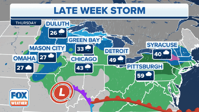
By Thursday, this storm system is expected to bring soaking rain to much of the Northeast and mid-Atlantic. However, with cold air in place across parts of New England and the higher terrain of upstate New York, there could be accumulating snow or a wintry mix changing to accumulating snow in those areas from Thursday into Friday.
HERE'S WHY THE U.S. HAS THE LOWEST SNOW COVER IN OVER A DECADE
The FOX Forecast Center said the current guidance from computer forecast models suggests this could be a fairly impactful winter storm from the Adirondacks and Catskills of upstate New York into portions of central and northern New England, but confidence is still low on exactly how impactful it might be.
Regardless, the Interstate 95 corridor, which has been mostly snowless so far this winter, will likely see all rain from this storm system.
By late Friday, the storm will finally exit off the East Coast.
The forecast for Thursday and Thursday night, Jan. 19, 2023.
(FOX Weather)