Here's why the US has the lowest snow cover in over a decade
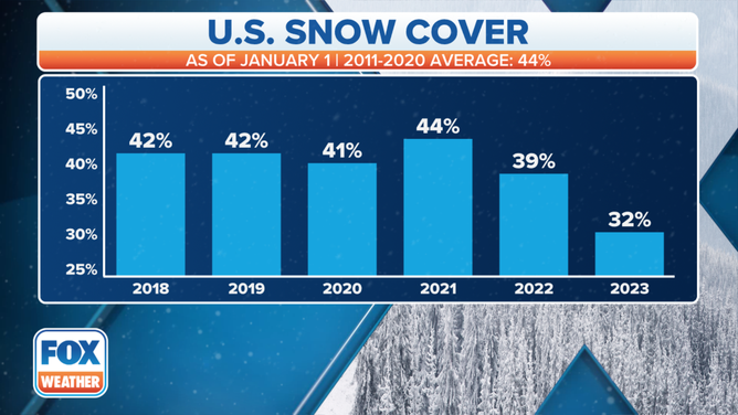
Just 31.5% of the Lower 48 was covered in snowfall on Jan. 1, according to NOAA. That is the lowest amount of snow coverage in more than a decade since 2012's paltry 19.8% snow coverage.
Why the East Coast is seeing a lack of snow
FOX Weather's Jane Minar goes in-depth as to why the East Coast is seeing a lack of snow so far this winter season.
NEW YORK -- For many in the Northeast this winter, it's been out with the "walking in the winter wonderland" and in with the "singing in the rain."
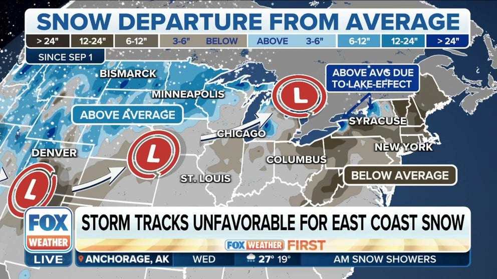
Several cities along the I-95 corridor have yet to see measurable snow, and it's contributing to a rather unusually blank national snow cover map as we reach the heart of winter.
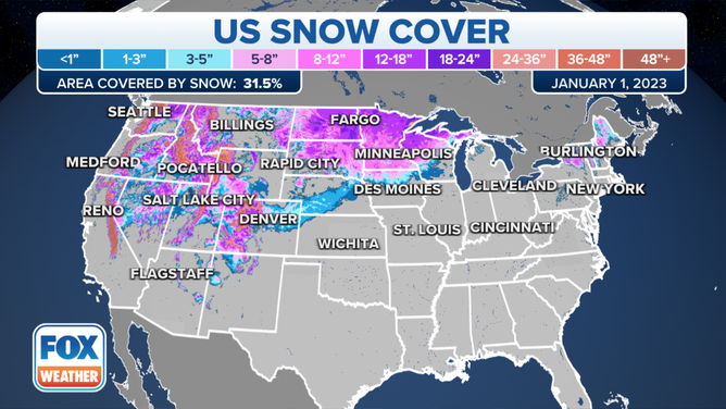
Just 31.5% of the Lower 48 was covered in snowfall on Jan. 1, according to NOAA.
(FOX Weather)
That is the lowest amount of snow coverage in more than a decade since 2012's paltry 19.8% snow coverage. The nation averages about 44% of its turf covered in snow this time of year.
WHERE IS THE SNOW? US APPROACHES MIDPOINT OF METEOROLOGICAL WINTER
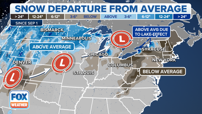
And even more unusual is most of that snow is out in the West, which has had recent droughts. The Rockies and Sierra Nevada are carrying healthy snowpack thanks to relentless snowstorms, and the Northern Plains have their snow. But much of the Great Lakes and Northeast, outside of the highest elevations, are blank.
(FOX Weather)
Even the Buffalo area, which had two massive blizzards at the end of 2022 that left several feet of snow in their wake, saw it all quickly melt away as temperatures shot into the 50s. Buffalo's airport had 28 inches of snow on the ground on Dec. 27; it was down to 5 inches on Jan. 1 and gone three days later. Northeast ski resorts are struggling because they've had to make their own snow, or many of their ski runs are covered with grass and no snow at all.
HOW TO WATCH FOX WEATHER ON TV
And now much of the East is trending toward experiencing among their warmest Januarys. Why?
The weather pattern has become rather stubborn, and it's not in a very cold phase for the East.
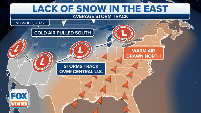
Storm track keeps it warm in East, wet in West
"With this current (weather pattern) setup, we've really largely missed out on a lot of our big snow events on the East Coast," says FOX Weather Meteorologist Jane Minar.
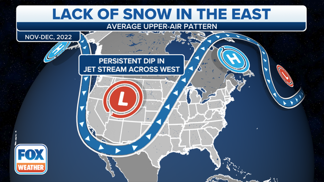
For the last few weeks, there has been a big, persistent dip in the jet stream out in the West, bringing in storm after storm.
(FOX Weather)
"But because of this dip in the jet stream, we see a pronounced ridge beginning to build in off to the East," Minar said.
MAJOR CITIES ALONG I-95 CORRIDOR THREATEN SNOWLESS STREAK RECORDS AMID LONG WAIT FOR FIRST SNOW
Low-pressure centers have been moving along the jet stream, which separates the warm air from the cold air, but because of the stubborn ridge along the East Coast, warmer air continues to get funneled up from the Gulf of Mexico all the way up into the Great Lakes region, leaving cold air trapped up to the north.
(FOX Weather)
"As storms track their way up through the Great Lakes region, interacting with more mild air, it really inhibits the snow machine to turn on," Minar said.
A brief arctic outbreak swept through the Northeast in late December, but moisture was lacking as the cold air arrived in the I-95 corridor. And now, in January, temperatures have been consistently above normal, allowing precipitation to fall as rain.
FROM 50 DEGREES TO BELOW ZERO: ARCTIC FRONT SENDING INSTANT BONE-CHILLING BLAST OF FRIGID AIR
(FOX Weather)
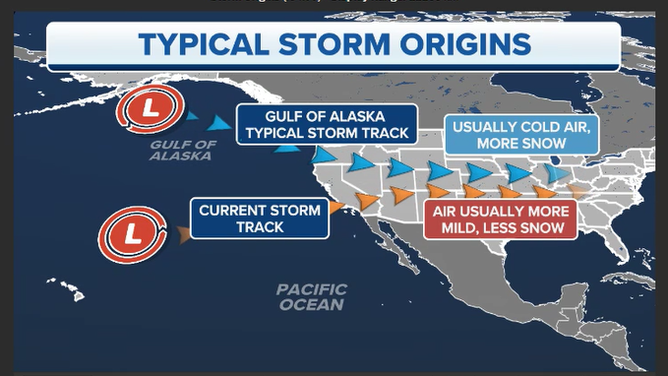
And it's not just where the storms are tracking, but where they're originating from out West that can determine whether a storm in the northern tier of the nation is snow or rain.
"What we've seen this entire winter season is that with the current track, these storms are coming out of the Central Pacific (Ocean)," says FOX Weather Meteorologist Britta Merwin. "And so many times we will be like, oh, it's a Pacific storm. So that means that it's warm. Well, not all the time."
(FOX Weather)
Last winter, several storms swept through the Pacific Northwest, where the storm track was coming out of the Gulf of Alaska.
"That had a lot more cold air with it… remember all those images that we saw of the snow in Washington? And then, as the storm progressed out towards the Plains, we had these massive blizzards across the Dakotas… and we were able to see more snow last year across the Great Lakes because the origin of these storms was from the Gulf of Alaska. It was pulling in colder air. It was a more northerly track," Merwin said.
And because the storms this January are coming out of the central Pacific, there is more warm air intrusion and a pattern that isn't tapping into colder air that's up to the north.

(FOX Weather)
"That polar vortex is still well up into Canada and then up towards the poles," Minar said. "And so we're really working with just milder air across the country."
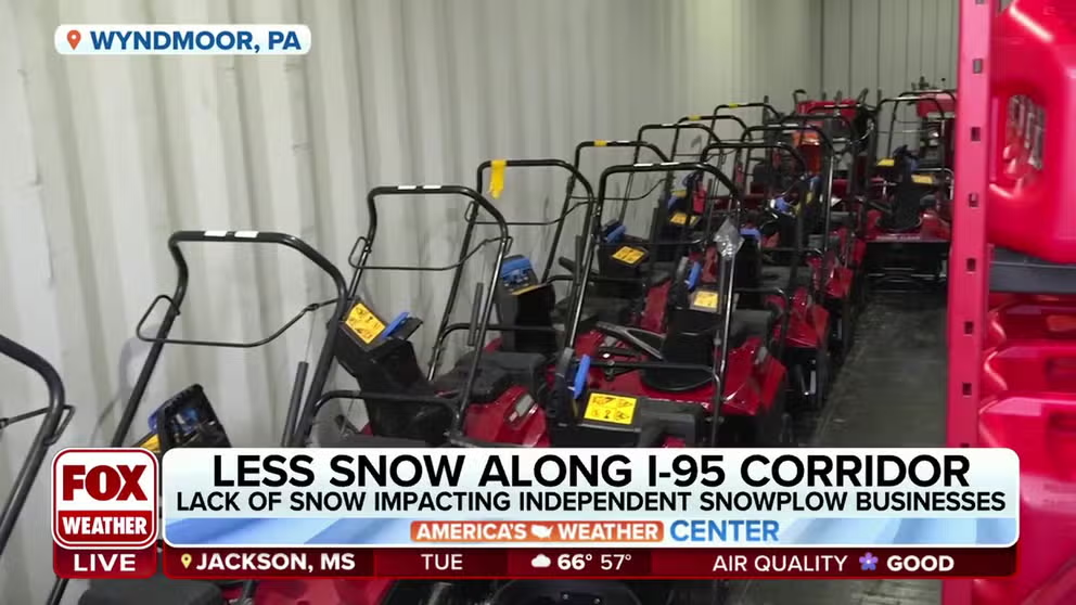
Lack of snow leaves an impact on snow-fueled businesses
The lack of snow has meant some local and state governments have saved a fortune because they don't have to bear the costs of clearing it. But independent snowplow businesses aren't seeing the usual green they get from the white stuff.
Ian Oelschlegel, who co-owns Suburban Snow Plow in the Philadelphia suburb of Wyndmoor, says if they don’t get any calls in January, they could lose 30% of their revenue for the season.
Winter drought impacts snowplow businesses in Northeast
In the Northeast, independent snow removal companies are coping with below-average snow for this time of year. Businesses hope February brings more accumulation. FOX Weather’s Katie Byrne has the latest from Wyndmoor, Pennsylvania.
"We're not anticipating much work until probably February," he said. "We have a lot of contractors; some of those people are in other businesses such as roofing, masonry, but they do certainly look for the snow to come because snow means money for their pockets."
In an average winter, Suburban Snow Plow typically responds to about a dozen events -- though not always dependent on snowfall. They could be out de-icing or spreading salt during a cold snap or rain.
When does the pattern change?
There is no hope for snow in the East for at least the next two weeks. The 8-14 day forecast from NOAA shows very high confidence of continued above-average temperatures across the eastern half of the nation.
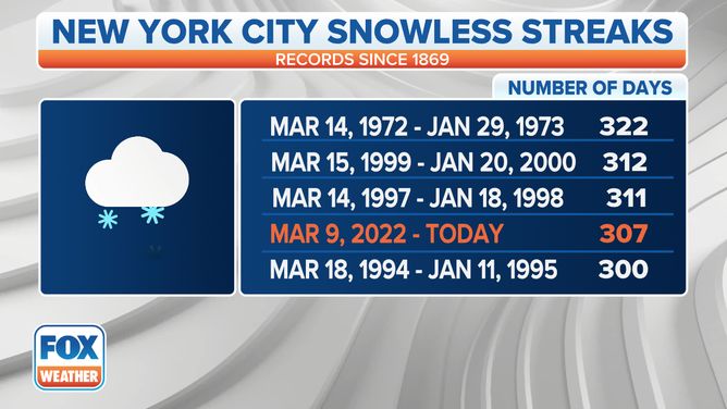
New York is already at its 4th-longest streak without measurable snow at 307 days, and looks like it will easily move into second place within a week.
(FOX Weather)
However, long-range forecasts do show California eventually drying out toward the end of that period which may finally stir up the atmosphere and perhaps cool things down along the East. Though the long-range forecasts are still trending warm and mild for the East.