Tropical Cyclone Narelle makes first landfall in Australia with destructive winds, flooding and storm surge
The cyclone is now tracking toward the eastern Northern Territory, where it's expected to make landfall on Sunday morning.

Watch: Sun rises over Australia as powerful Tropical Cyclone Narelle makes landfall over Queensland
Tropical Cyclone Narelle made landfall over Queensland as a Category 4 cyclone on Friday. Minimal damage was reported as the cyclone moved through the state on Friday. By Sunday morning, Narelle will make a second landfall in Australia's Northern Territory.
QUEENSLAND, AUSTRALIA — Tropical Cyclone Narelle made landfall in northern Queensland, Australia, on Friday, and is now back over water before bringing a second landfall to Australia's Northern Territory.
The cyclone made landfall as a Category 4 cyclone, with wind gusts at its core measuring 250 km/h or 155 mph.
Dangers included violent winds large debris that may become airborne, a serious risk of injury, flooding and dangerous storm surge.
5 DIFFERENT NAMES FOR HURRICANES AROUND THE WORLD

Tropical Cyclone Narelle strengthens over the northern Coral Sea, March 18.
(@CIRA_CSU / X)
Australia's Bureau of Meteorology said the storm weakened to a category 3 as it moved through North Queensland, and is now back over water in the Gulf of Carpentaria.
Heavy rain and damaging winds were reported at the hurricane's first landfall. Rain measurements in the Wenlock River in Queensland were reported at 200 mm, or 7.8 inches.
Premier of Queensland David Crisafulli said in a Friday evening update that some damage was reported in Queensland, but "damage has been relatively minimal."
He noted downed trees, flooding and power outages across the state.
Crisafulli said response and recovery operations are already underway in Queensland.
FEROCIOUS FREDDY: MEET THE LONGEST-LIVED TROPICAL CYCLONE IN HISTORY

The sun beginning to rise over Queensland as Tropical Cyclone Narelle made landfall late Thursday night.
(CIRA_CSU/X / NOAA)
The cyclone is now tracking toward the eastern Northern Territory, where it's expected to make landfall on Sunday morning.
A Cyclone Emergency Warning was issued by the Aurukun Disaster Group, and residents were advised to take shelter immediately.
Approximately 500 residents of Numbulwar are being airlifted to Darwin, according to the Northern Territory Government.
Forming in the Coral Sea, the system was initially classified as a Category 2 cyclone on March 17–18 by the Bureau of Meteorology in Australia, before quickly strengthening to Category 4, and then intensifying further into a Category 5 storm on March 19.
ATLANTIC 2026 HURRICANE SEASON COULD SEE MAJOR IMPACTS FROM POTENTIALLY STRONG EL NIÑO
![Commuters wade across a flooded street after heavy rains ahead of Cyclone Michaung's landfall in Chennai on December 3, 2023.]() Image 1 of 5
Image 1 of 5Commuters wade across a flooded street after heavy rains ahead of Cyclone Michaung's landfall in Chennai on December 3, 2023. (Photo by R. Satish BABU / AFP) (Photo by R. SATISH BABU/AFP via Getty Images) ( )
![]() Image 2 of 5
Image 2 of 5Commuters make their way through a flooded road after heavy rains in Chennai on December 4, 2023. Cyclone Michuang is expected to make landfall on December 5 along the southern coast. (Photo by R. Satish BABU / AFP) (Photo by R. SATISH BABU/AFP via Getty Images) ( )
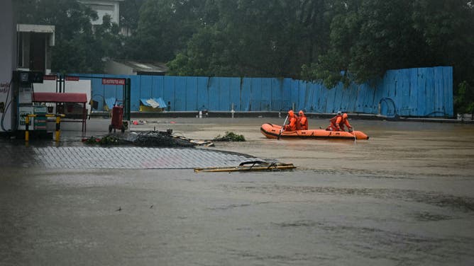
![National Disaster Response Force (NDRF) personnel row a boat through a flooded street, during a rescue operation to help trapped civilians following heavy rainfall in Chennai on December 4, 2023.]() Image 3 of 5
Image 3 of 5National Disaster Response Force (NDRF) personnel row a boat through a flooded street, during a rescue operation to help trapped civilians following heavy rainfall in Chennai on December 4, 2023. (Photo by R. Satish BABU / AFP) (Photo by R. SATISH BABU/AFP via Getty Images) ( )
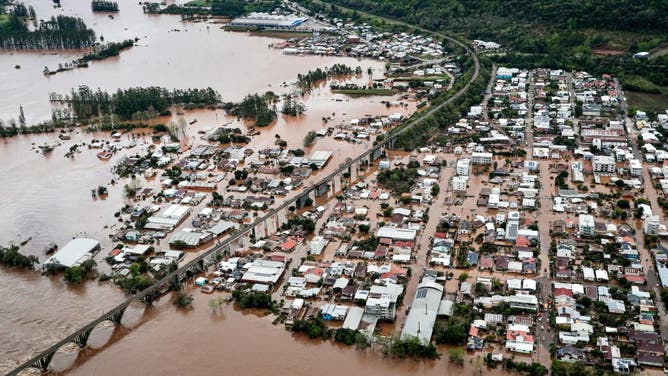
![Aerial view of the area affected by an extratropical cyclone in Muçum, Rio Grande do Sul State, Brazil, taken on September 5, 2023.]() Image 4 of 5
Image 4 of 5Aerial view of the area affected by an extratropical cyclone in Muçum, Rio Grande do Sul State, Brazil, taken on September 5, 2023. Torrential rain and winds caused by an extratropical cyclone have left at least 21 people dead in southern Brazil, officials said Tuesday, warning more flooding may be coming. (MATEUS BRUXEL/AGENCIA RBS/AFP)
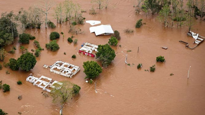
![]() Image 5 of 5
Image 5 of 5Aerial view of the area affected by an extratropical cyclone in Muçum, Rio Grande do Sul State, Brazil, taken on September 5, 2023. Torrential rain and winds caused by an extratropical cyclone have left at least 21 people dead in southern Brazil, officials said Tuesday, warning more flooding may be coming. The latest in a string of weather disasters to hit Brazil, it is the deadliest ever in the state of Rio Grande do Sul, Governor Eduardo Leite told a news conference. (Photo by Mateus BRUXEL / AGENCIA RBS / AFP) / Brazil OUT (Photo by MATEUS BRUXEL/AGENCIA RBS/AFP via Getty Images) (BRUXEL / AGENCIA RBS / AFP)


Heavy rainfall will be associated with the storm, along with large waves, likely triggering minor to dangerous flooding.
The Bureau notes that the tides in the Princess Charlotte Bay are likely to rise well above normal high tide, accompanied by destructive waves and significant flooding.
They also warned of possible hazardous storm tide as the center of the cyclone crosses the coast.
How often do tropical cyclones occur in the region?
The Bureau of Meteorology in Australia states that, on average, the Australian region experiences 10 tropical cyclones each season, with three to four of them making landfall, based on data from 1980 to 81 and onward.
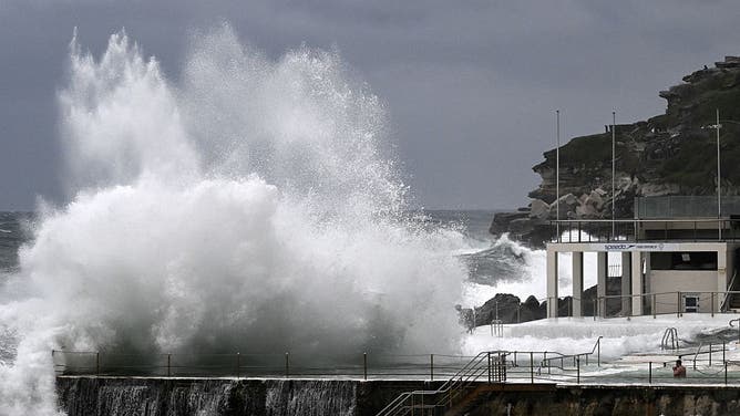
Large waves crash into the Bondi Baths and Icebergs Club at Sydney's famous Bondi Beach on July 2, 2025, as large swells and high winds hit the east coast of Australia.
(Photo by SAEED KHAN/AFP via Getty Images / Getty Images)
"There has always been at least one tropical cyclone that crosses the Australian coast each season," they said, with quiet periods usually followed by bursts of activity.
Stay prepared by following the latest updates and tracking the storm on the Bureau of Meteorology website, where they provide detailed information on targeted areas.