Massive storm to make Christmas travel messy for millions across central US
The far-reaching storm will bring with it rain, snow, and even ice as it moves across the country during the long Christmas weekend.
Large storm brewing for Christmas Eve could snarl travel across the central US
From flooding rains in the southern Plains to snow and freezing rain in the Upper Midwest, the forecast is tricky and messy for those trying to get around for the Christmas holiday.
The millions of people who are expected to travel during the long Christmas weekend will face a tricky trip if their route takes them across the central U.S.
A powerful storm that has already caused problems for Southern California and the Desert Southwest this week and fueled by an El Niño-charged southern jet stream will team up with another storm dropping out of the Pacific Northwest to create a variety of impactful weather.
Here’s a closer look at the far-reaching storm.
CHRISTMAS TRAVEL WEATHER LIVE TRACKER: CURRENT RADAR, AIRPORT STATUS, FLIGHT DELAYS AND MORE

(FOX Weather)
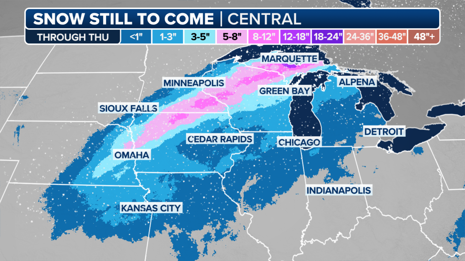
Heavy snow possible from West to northern Plains
Pockets of heavy snow are expected as the storm makes its way across the central U.S. this weekend.
The snow really gets cranking in the Rocky Mountains from Montana to Colorado, where upwards of 2 feet of snow is possible by Christmas Eve in the highest elevations.

(FOX Weather)
"Maybe Denver getting some rain into snow, maybe 1-3 inches worth," FOX Weather Meteorologist Bob Van Dillen said.
CHRISTMAS LAWN DECORATIONS ARE SOMETIMES NO MATCH FOR MOTHER NATURE

(FOX Weather)
The northern Plains could also see snow in two different batches through Christmas Day as the storm moves east. Around 5-8 inches of snow is possible along the Nebraska-South Dakota border, with some areas seeing upwards of 8-12 inches of snow. Minneapolis, Minnesota, could even see a few flakes fly before all is said and done.
(FOX Weather)
For those traveling by car, Interstates 76, 80, and 90 could see the worst wintry weather with periods of heavy snow and gusty winds. Wind gusts of 25-35 mph over the Plains could create some areas of blowing and drifting snow, further slowing drivers.
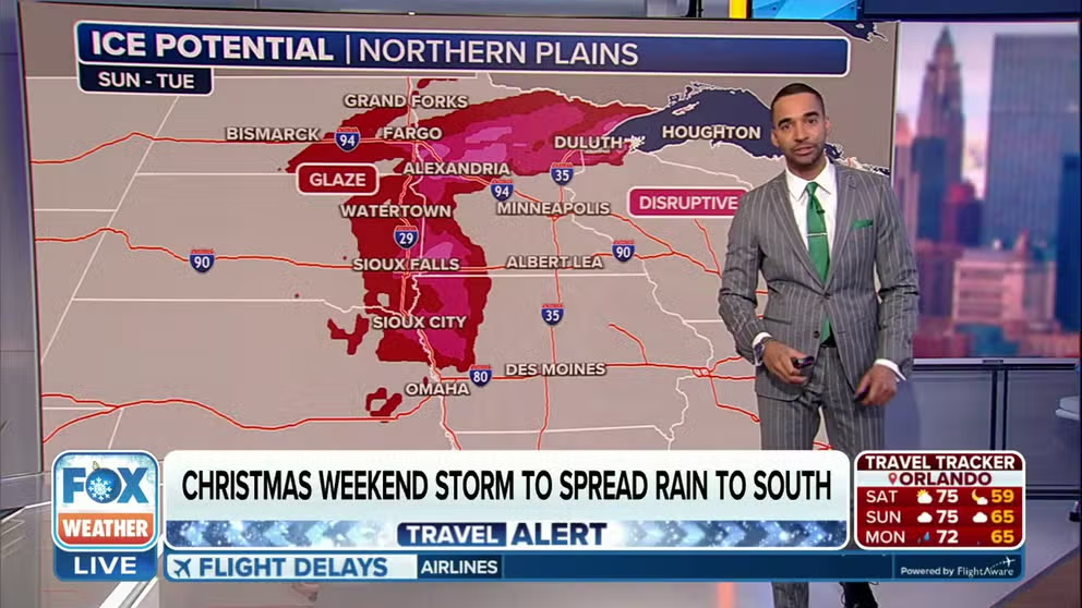
Icy weather could make for slippery roads
Where the warm air and cold air collide in this storm, some people could see an icy mix of wintry weather.
The best chances of any ice accretion appear to be focused along Interstate 29 in the eastern Dakotas and western Minnesota, where freezing rain is possible after lunch on Christmas.

(FOX Weather)
The freezing rain threat spreads north and east Monday night. By Tuesday, a band of freezing rain with potentially disruptive amounts of ice accretion could set up across northern Minnesota into far northern Wisconsin. Right now it appears the freezing rain will stay north of Minneapolis but potentially affect Duluth.
"Unfortunately for a lot of folks that are going to be driving in parts of the Upper Midwest from Duluth to Fargo to Watertown (South Dakota), up and down (Interstate) 29 and 94 towards Bismarck, you could see a couple slick spots on those roads," said FOX Weather Meteorologist Michael Estime.
Heavy rain to raise risk of flooding across South
On the warm side of this storm is where heavy rain poses a risk of flash flooding through Christmas weekend.
"A lot of moisture is being fed up from the Gulf (of Mexico) and that’s going to fuel some of those storms and heavy rain over Texas," said FOX Weather Meteorologist Craig Herrera. "That combined with an area of low pressure coming through with Pacific moisture — so you have TWO sources of moisture coming together, but it’s that moisture coming off the Gulf that’s going to enhance those rainfall rates."
Rain begins to pick up Saturday night across the southern Plains in a swath from Kansas to Texas. Coverage increases on Christmas Eve, with rain stretching from the Canadian border to the Gulf Coast.
MOST IN U.S. WILL EXPERIENCE CHRISTMAS WITHOUT SNOW THIS YEAR

(FOX Weather)
The risk of flash flooding exists in nearly a dozen southern states through Christmas weekend. Parts of Alabama, Arkansas, Louisiana, Mississippi, Oklahoma and Texas face a Level 2 out of 4 risk of flooding on Christmas Eve.

(FOX Weather)
Widespread rainfall totals of 1-2 inches are likely across the region, with many spots reaching 3 inches in heavier showers. There is a chance of a few isolated areas receiving as much as 5 inches of rain.
On Christmas Day, that Level 2 risk moves east and includes parts of Alabama, Florida, Georgia, and South Carolina.
CHRISTMAS TRAVEL TROUBLES: WHERE WEATHER COULD CAUSE PROBLEMS FOR FLIGHTS LEADING UP TO THE HOLIDAY

(FOX Weather)
Long range forecasts show the storm's front will eventually sweep through the East later in the week, bringing a round of chilly rain to the Northeast with some snow showers in the Great Lakes.