Severe thunderstorms, tornadoes possible along East Coast, including I-95 corridor, on Sunday
As storms continued to make their way up the East Coast Sunday, a tornado was reported in Virginia Beach. The twister reportedly knocked a tree onto a vehicle near Great Neck Middle School, trapping a person inside.
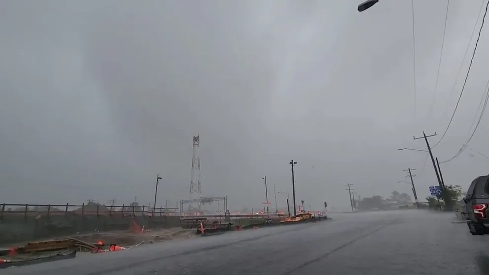
Weekend washout continues in the Northeast, mid-Atlantic
The weekend washout will continue on Sunday with heavy rain leading to flooding concerns in the Northeast and New England white forecasters keep a close eye on the possibility of strong to severe thunderstorms in the mid-Atlantic.
The weekend washout along the East Coast continues on Sunday, with more heavy rain expected in the Northeast while millions of people from the Delmarva Peninsula to the Carolinas brace for the threat of severe weather, including possible tornadoes.
The East Coast deluge began Friday morning and brought rain to the Carolinas and mid-Atlantic before moving into the Northeast on Friday evening. The rain continued into Saturday morning, and the region saw a brief break in the action later Saturday.
TORNADO SPOTTED IN VIRGINIA BEACH, 'MAJOR STORM DAMAGE' REPORTED IN NEIGHBORHOOD
Tornado spotted in Virginia on Sunday
The National Weather Service issued a Tornado Warning for the Virginia Beach area on Sunday. Tyler Anderson said he spotted the likely tornado or waterspout from the Willoughby Spit area.
As storms continued to make their way up the East Coast Sunday, a tornado was reported in Virginia Beach. The twister reportedly knocked a tree onto a vehicle near Great Neck Middle School, trapping a person inside.

(FOX Weather)
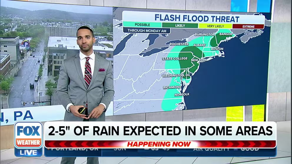
Soggy Sunday in the Northeast
The FOX Forecast Center said Sunday will be a wet and chilly day across the region as a low-pressure system tracks inland and pulls in the warm, moist air from as far south as South Florida.
This will increase the risk of heavy rain, likely producing region-wide rainfall totals higher than 1 inch.
The highest rainfall totals will be confined to coastal and interior northern New England, where more than 2 or 3 inches of rain could fall, with hourly rainfall rates higher than 1 inch possible.

(FOX Weather)
As a result, there is a risk of some flash flooding for parts of Massachusetts, New Hampshire and southern Maine.
Farther south, there is also the risk of flash flooding in parts of New Jersey, eastern Pennsylvania, southern New York and the Baltimore and Washington areas.
EXPLAINING FLOOD ALERTS ISSUED BY THE NATIONAL WEATHER SERVICE

(FOX Weather)
Because of the threat of heavy rain, the National Weather Service issued a Flood Watch for most of New Hampshire, including the cities of Nashua, Manchester, Concord, Conway and Berlin. In Maine, a Flood Watch is in effect in cities from Sanford through Portland, Augusta, Skowhegan and Farmington.
In central New York, Flood Watches are in effect for cities such as Elmira, Ithaca, Syracuse, Binghamton and Monticello.
Eastern Pennsylvania, New Jersey and Delaware are also included in a Flood Watch that will run through Sunday evening. This watch includes Philadelphia, Allentown and Harrisburg in Pennsylvania; Atlantic City, Newark and Trenton in New Jersey; and Wilmington and Dover in Delaware.
Severe weather possible in Carolinas, mid-Atlantic

(FOX Weather)
There is also a concern that severe thunderstorms, including possible tornadoes, will develop along the East Coast from the Delmarva Peninsula south through the Carolinas on Sunday.
The FOX Forecast Center said large hail, damaging winds and tornadoes will be possible during the morning and early-afternoon hours, but conditions will begin to improve from the south to the north as the cold front sweeps through the region by late afternoon.
![The tornado threat on Sunday, April 30, 2023.]() Image 1 of 3
Image 1 of 3The tornado threat on Sunday, April 30, 2023. ( )
![The large hail threat on Sunday, April 30, 2023.]() Image 2 of 3
Image 2 of 3The large hail threat on Sunday, April 30, 2023. ( )
![The damaging wind threat on Sunday, April 30, 2023.]() Image 3 of 3
Image 3 of 3The damaging wind threat on Sunday, April 30, 2023. ( )


