New England's hurricane history is filled with disastrous storms over the last century
Over the years, hundreds of deaths and billions in damage have been attributed to hurricanes that have struck New England
Major hurricanes that have hit New England
It doesn’t happen often, but hurricanes have hit New England in the past. Here’s a loot at some of the biggest storms to impact the region.
Historically, most tropical storms and hurricanes have made landfall along the Gulf Coast and along the U.S. East Coast from Florida to the mid-Atlantic. However, powerful and deadly storms have made their way farther north, wreaking havoc across the Northeast and New England.
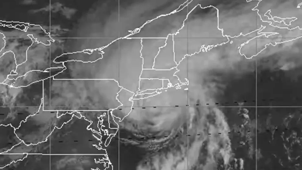
While Hurricane Lee looks like it will avert a northeastern U.S. landfall, several other previous storms haven't left the region so lucky. Here are some of the most significant tropical storms and hurricanes that have impacted the region:
The Great New England Hurricane (1938)
The Great New England Hurricane of 1938, also known as the Long Island Express, was one of the most powerful and destructive hurricanes in history. It struck Long Island, New York and southern New England on Sept. 21, 1938.
The National Weather Service said the storm developed near the Cape Verde Islands on Sept. 9, tracked up the East Coast, and slammed into New York and New England less than two weeks later.
By Sept. 18, the center of the hurricane was located just north of Puerto Rico, and forecasters feared that the storm would hit Florida. By the next day, the storm began to take a turn to the north as it was centered 650 miles to the east-southeast of Miami.
At that time, it was still believed that the storm would impact the Sunshine State, and people were warned about the approaching storm.
In New England, there was little concern for the storm, but on Sept. 20, the storm was instead headed north and storm warnings were issued along the coast to Atlantic City, New Jersey.
![]() Image 1 of 9
Image 1 of 9Hurricane Storm winds blowing trees. Connecticut house is tossed back from roadway. Maple tree is uprooted and knock down. (Photo By: /NY Daily News via Getty Images) (New York Daily News)
![]() Image 2 of 9
Image 2 of 9(Original Caption) 9/22/1938-New London, CT- The town of New London was one of the hardest hit by the West Indies hurricane which tore through the Long Island and New England region last night, September 21st. Scores lost their lives here, and property damage was great. A fire added its horror to the howling wind and rising waters. The million-dollar blaze is shown still burning hours after the high winds died down. (Bettmann)
![]() Image 3 of 9
Image 3 of 9(Original Caption) A view showing the extent and magnitude of damage wrought by the tropical hurricane along the New London waterfront. Piers have been smashed to tinderwood, boats lie half-submerged and thrown up on the shore. On the left, a faint pall of smoke indicates the numerous fires which broke out. (Bettmann)
![]() Image 4 of 9
Image 4 of 9Views of storm hurricane damage in New London, Conn. (New York Daily News)
![]() Image 5 of 9
Image 5 of 9Hurricane Storm - Westhampton, L.I. (Photo By: /NY Daily News via Getty Images) (New York Daily News)
![]() Image 6 of 9
Image 6 of 9(Original Caption) 9/23/1938-Waterville, MA-Floods due to a hurricane make transportation impossible as they carry away sections of highway along the New England coast. (Bettmann)
![]() Image 7 of 9
Image 7 of 9Views of storm hurricane damage in New London, Conn. (New York Daily News)
![]() Image 8 of 9
Image 8 of 9(Original Caption) Police and fireman worked for over an hour on the night of September 21st to free three youths who were trapped in this auto. A large elm tree was uprooted by the high wind. The accident occurred on Noxon Street, in the south section of the city. The gale was the tail end of the hurricane that lashed the Eastern seaboard. (Bettmann)
![]() Image 9 of 9
Image 9 of 9(Original Caption) The two persons riding in this car narrowly escaped death when this huge tree toppled on it during the height of the terrific gale which swept the Eastern seaboard on September 21st. Rains and winds, just short of the hurricane force, caused widespread damage. Many deaths were reported in New England, where bursting dams sent torrents down on roads and farms. (Bettmann)


By early morning on Sept. 21, the storm was located about 275 miles south of Cape Hatteras, North Carolina, and its forward speed increased.
Within eight hours, the center of the storm was just 75 miles from Cape Hatteras, and storm warnings were extended north into New England.
Conditions began to deteriorate from New York City to the eastern end of Long Island by 1 p.m. that afternoon when the storm was about 150 miles to the south of Fire Island, New York. Forecasters said the pressure was dropping, and winds and waves were picking up in intensity.
By then, the storm was racing north at 47 mph and made landfall near Bellport, New York, between 2 and 2:30 p.m. with winds estimated to be about 120 mph.
About 60 people were killed, and hundreds more were injured on Long Island. In addition, farms and their livestock were destroyed.

What's the difference between a Tropical Depression, Tropical Storm, and Hurricane?
Tropical Depressions, Tropical Storms, and Hurricanes all have different characteristics that are compared and contrasted in this video
The hurricane continued to cut a path across Long Island, and eventually made a second landfall around 4 p.m. somewhere between Bridgeport and New Haven, Connecticut, with winds of about 115 mph.
Hundreds of people were killed in Connecticut, and many more were injured. There was also extensive damage reported to homes, trees and farms.
New London, Connecticut, reported a storm surge of nearly 10.6 feet, a record high that still stands. Stamford, Connecticut, saw a storm surge of 14.1 feet, while Bridgeport reported 12.8 feet. The highest storm surge, however, was reported in Rhode Island at 17 feet.
Overall, at least 700 people were killed in the hurricane, and about 63,000 people were displaced.
Damage was estimated to be $620 million, which would be $12.7 billion today.
As quickly as the storm arrived, it exited the region. After making its second landfall in Connecticut that afternoon, the storm had made its way well into Vermont by about 6 p.m., and conditions to the south had started to improve.
HOW ARE HURRICANES RATED? THE SAFFIR-SIMPSON HURRICANE WIND SCALE EXPLAINED
The Twins: Hurricanes Carol and Edna (1954)

Hurricanes Carol and Edna (The Twins) in 1954
Two Category 3 hurricanes struck New England within days of one another in 1954.
In 1954, two Category 3 hurricanes known as "The Twins" slammed into New England within days of one another, killing 80 people and causing more than $500 million in damage.
According to the National Hurricane Center, Hurricane Carol formed near the Bahamas on Aug. 25 and moved slowly to the north-northwest for several days.
On Aug. 30, Carol was located about 100-150 miles to the east of Charleston, South Carolina, and began to pick up speed as it headed to the north-northeast.
Carol made landfall as a Category 3 storm on Long Island, New York, later on Aug. 30, and then again in Connecticut the next day.
The storm became extratropical as it moved across the rest of New England and eventually into Canada.
The NHC said sustained winds between 80 to 100 mph were reported across eastern Connecticut, all of Rhode Island, as well as across eastern Massachusetts.
A peak wind gust of 130 mph was reported on Block Island, Rhode Island, while gusts of 100 to 125 mph were reported across the region.
Storm surge flooding brought water depths between 8 and 10 feet in downtown Providence, Rhode Island.

Storm surge explained by FOX Weather Hurricane Specialist Bryan Norcross
What are the dangers of storm surge and how high can waters reach? FOX Weather Hurricane Specialist Bryan Norcross explains.
The NHC said Carol was responsible for 60 deaths in New England and caused $461 million in damage.
Barely 48 hours after Carol slammed into New England, another powerful storm was beginning to form.
Hurricane Edna first formed near the Windward Islands on Sept. 2 and continued on a northwesterly path for several days.
On September 7, the NHC said Edna became a hurricane in nearly the same spot Carol had formed almost two weeks before and continued on a path just east of where Carol had tracked up and along the East Coast.
It began to speed past the Carolinas on Sept. 10 and made landfall on Cape Cod, Massachusetts, on Sept. 11.
After crossing the Cape, Edna continued to move to the northeast and across Maine later in the day as it became extratropical.
A wind gust of 120 mph was reported on Martha's Vineyard in Massachusetts as Edna moved through the region, and gusts of between 80 and 100 mph were reported as well.
In total, Edna was responsible for 20 deaths and caused $40 million in damage.
WHAT’S THE DIFFERENCE BETWEEN A TROPICAL DEPRESSION, TROPICAL STORM AND HURRICANE?
Hurricane Gloria (1985)
Hurricane Gloria was a powerful hurricane that formed near the Cape Verde Islands on Sept. 15, 1985 and spun across the Atlantic Ocean before making three landfalls in the U.S.
According to the National Weather Service, Gloria became a tropical storm on Sept. 17, but conditions were unfavorable for development, and it was lowered to a tropical depression the following day.
However, Gloria was able to strengthen as it passed close to the Lesser Antilles and became a hurricane when it was about 620 miles to the east-southeast of St. Croix, U.S. Virgin Islands.
Gloria continued to strengthen and became a major hurricane on Sept. 24 as the storm passed to the northeast of the Bahamas with winds of 145 mph.
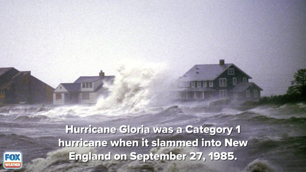
Hurricane Gloria (1985)
Hurricane Gloria was a Category 1 hurricane when it slammed into New England in 1985.
Hundreds of thousands of people from the Carolinas to Connecticut were evacuated from the coast. In the early morning hours of Sept. 27, Hurricane Gloria made its first landfall on Hatteras Island in North Carolina with winds of 105 mph.
The storm continued to move to the northeast and made its second landfall later in the day between John F. Kennedy Airport and Islip, New York, with winds of about 85 mph.
About an hour later, Gloria passed over Long Island into Long Island Sound and made its third and final landfall as a Category 1 hurricane near Westport, Connecticut.
The storm eventually became extratropical as it spun over New England and into Canada.
In total, eight people were killed, and the storm caused $900 million in damage.
WATER FROM HURRICANES, TROPICAL STORMS KILLS MORE IN U.S. THAN WIND
Hurricane Bob (1991)
Hurricane Bob was the second named storm and the first hurricane of the 1991 Atlantic hurricane season.
Bob first developed in the central Bahamas on Aug. 16, then continued to intensify and reached hurricane status during the evening hours of Aug. 17.
Over the next 48 hours, the National Weather Service said Bob continued to strengthen as it continued on a path to the north-northeast while skirting the East Coast.
On Aug. 19, the eye of Hurricane Bob passed over Block Island, Rhode Island, at about 1:30 p.m. and made landfall as a Category 2 hurricane over Newport, Rhode Island, just before 2 p.m.
Sustained hurricane-force winds between 75 and 100 mph were felt along the coast of Rhode Island and most of southeastern Massachusetts.
Tropical-storm-force winds were felt across southern New England, with many areas east of the Connecticut River experiencing hurricane-force wind gusts.
The NWS said the highest sustained wind of 100 mph was reported in North Truro, Massachusetts.

Hurricane Bob (1991)
Hurricane Bob made landfall as a Category 2 hurricane in Newport, Rhode Island, on August 19, 1991.
Block Island also reported sustained winds of 90 mph with gusts higher than 105 mph. Gusts near 100 mph were also recorded in Newport.
Hurricane Bob caused a storm surge in Rhode Island between 5 and 8 feet, with a storm surge of 10 to 15 feet in Buzzards Bay in Massachusetts.
The NWS said the highest surge reported from Hurricane Bob was between 12 and 15 feet in Onset, Bourne, Mashpee and Wareham in Massachusetts.
Dozens of homes along the coast of Massachusetts were damaged or destroyed, and officials said south-facing locations on Martha's Vineyard and Nantucket, Massachusetts, lost about 50 feet of the beach due to erosion.
Widespread rain totals between 3 and 6 inches were reported in southern New England, with Foster, Rhode Island, reporting the highest total of 7.01 inches of rain.
Hurricane Bob was blamed for 17 deaths along the East Coast. According to the NWS, six people died in Connecticut, including two children who lost their lives when a fire started by a candle.
The total damages in southern New England were about $680 million.
THE BEASTS OF THE ATLANTIC: 94 HURRICANE OR TROPICAL STORM NAMES THAT HAVE BEEN RETIRED
Hurricane Irene (2011)
Irene first became a named storm on Aug. 20 when it formed into a tropical storm near the Lesser Antilles.
By the time Irene made its first landfall in Puerto Rico on Aug. 22, the storm was a Category 1 hurricane and was still gaining strength.
It eventually grew into a Category 3 hurricane by Aug. 24 as it continued on a path to the northwest.
By the time Irene made another landfall in North Carolina on Aug. 27, the storm had weakened to a Category 1 hurricane.
Another landfall was made in Atlantic City, New Jersey, on the morning of Aug. 28, and the storm moved to the north-northeast, with the center of the storm moving over Coney Island, New York and then across western Connecticut into New England.
Once Irene moved into New England, however, it had been downgraded to a tropical storm and was extratropical when the center of the storm was near the New Hampshire/Vermont border on the evening of the 28th.
Hurricane Irene (2011)
By the time Irene reached New England, it was downgraded to a tropical storm. But the effects were still devastating for the region.
Irene's effects across the region were devastating.
Catastrophic flooding was reported in New York and across New England, especially in southern Vermont and New Hampshire.
According to the National Weather Service, flash flooding was reported across many mountain valleys, and record-breaking flood stages were reported on larger rivers.
Puerto Rico recorded at least 22 inches of rain from Irene, with many areas along the East Coast picking up between 5 and 10 inches.
There were higher totals, however, like in Bayboro, North Carolina, where nearly 16 inches fell.
Irene was responsible for 40 deaths in the U.S., including Puerto Rico.
The National Hurricane Center said six deaths were attributed to the storm surge, 13 were wind-related deaths and 21 were due to rainfall-induced flooding.
BEWARE THE ‘I’ STORM: IT HAS MORE RETIREES THAN ANY OTHER LETTER USED FOR ATLANTIC HURRICANE NAMES
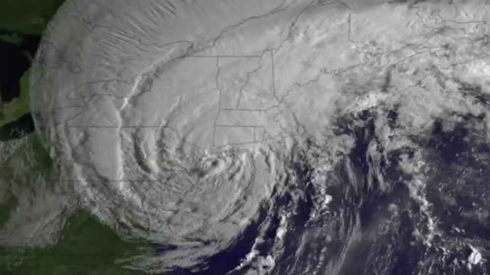
Superstorm Sandy (2012)
Superstorm Sandy was an entirely different storm when its effects were felt in New England.
The National Weather Service called it a "hybrid storm" that had both tropical and extratropical characteristics and brought high winds and severe coastal flooding to the region.
Sandy began as a low-pressure system near Kingston, Jamaica, on Oct. 22 and formed into a tropical storm as it spun off to the north, eventually crossing over eastern Cuba and the Bahamas.
Sandy continued on a northeastern track until it made a turn to the west toward the mid-Atlantic coast on Oct. 28.
The storm was then classified as a post-tropical cyclone just before making landfall near Atlantic City, New Jersey, on the 29th.
While Sandy didn't make landfall in New England, the storm's effects were felt across the region.
The NWS said winds gusted between 50 and 60 mph for interior southern New England, 55 to 65 mph along the coast of eastern Massachusetts and the I-95 corridor into Rhode Island and 70 to 80 mph along the southeastern Massachusetts and Rhode Island coasts.
Higher gusts were reported along the coast of Rhode Island.

Superstorm Sandy (2012)
Superstorm Sandy was an entirely different storm when its effects were felt in New England.
Moderate coastal flooding was reported in Massachusetts, while major flooding was reported in Rhode Island.
Sandy's storm surge was between 2.5 and 4.5 feet along the east coast of Massachusetts, with waves offshore reaching 20 to 25 feet. A storm surge between 4 and 6 feet was reported along the southern coast, with waves offshore reaching between 30 and 35 feet.
CLICK HERE TO GET THE FOX WEATHER UPDATE PODCAST
Rhode Island reported the strongest winds, with a peak gust of 86 mph being reported in Westerly, with nearly the entire Rhode Island coastline experiencing moderate to major coastal flooding.
In total, the NWS said there were at least 147 deaths reported across the Atlantic basin because of Sandy, with 72 of those deaths being reported in the mid-Atlantic and Northeast.
In a report, the NWS said that was the greatest number of direct fatalities related to a tropical cyclone outside the southern states since Hurricane Agnes in 1972.