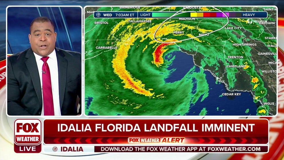
Hurricane Idalia now an extremely dangerous Category 3 storm ahead of historic landfall, catastrophic impacts
Hurricane Idalia's landfall in Florida is hours away as catastrophic storm surge and destructive, life-threatening winds are expected where the storm's core moves onshore in the Big Bend of the state.
Category 3 Hurricane Idalia's landfall in Florida to bring catastrophic storm surge
Hurricane Idalia's landfall in Florida will bring catastrophic storm surge and destructive, life-threatening winds where the storm's core moves onshore in the Big Bend of the state.
As of Wednesday at 7:45 AM, Hurricane Idalia has made a historic landfall near Keaton Beach, Florida, as a Category 3 storm. Continuous coverage of Hurricane Idalia has moved here.
The time to prepare is over and a dire situation is unfolding along Florida’s Gulf Coast as Category 3 Hurricane Idalia continues to rapidly intensify in the Gulf of Mexico. Catastrophic, life-threatening storm surge and destructive winds will pound the state’s Big Bend region as the monster storm nears the coast just hours away from landfall.
A storm surge of up to 16 feet in some spots is likely, disastrous winds of up to 130 mph, and a risk of significant flooding are all in the forecast as Hurricane Idalia is fueled by the warm waters of the Gulf of Mexico, according to the National Hurricane Center (NHC).
Dozens of counties in Florida are under a state of emergency and evacuations have been ordered in at least 30 counties as fears grow that walls of water will be forced inland as Hurricane Idalia makes landfall.
"Storm surge of this magnitude is not something we've ever seen in this part of Florida in any of our lifetimes," DeSantis said during a press conference on Tuesday afternoon. "So, please, please take the appropriate precautions."
However, the time to take those precautions has passed as the effects of Hurricane Idalia are being felt from the Florida Panhandle to the Fort Myers area as the storm slams the state’s Big Bend region.

(FOX Weather)
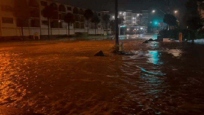
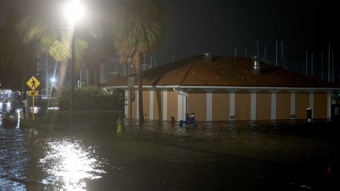
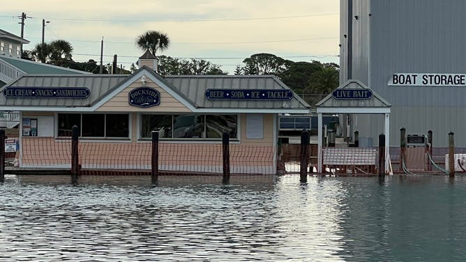
Access to Clearwater Beach was cut off early Wednesday morning due to flooding.
"You can leave the beach, but you cannot get there via Memorial Causeway or Sand Key," the Clearwater Police Department said on X, formerly Twitter. "We are seeing flooding in beach areas, and elsewhere in the city."
And it’s not only Florida that is feeling the storm’s effects. Other states in the Southeast are also preparing for the worst.
FLORIDA HURRICANE THREAT LIVE TRACKER: FUTURE PATH, WATCHES AND WARNINGS, SPAGHETTI MODELS AND MORE
Gov. Henry McMaster declared a State of Emergency for South Carolina on Tuesday. Tropical Storm Warnings and Storm Surge Watches are in place for coastal Georgia and South Carolina, including Charleston.
Dangerous Extreme Wind Warning issued for Florida’s Big Bend

(FOX Weather)
With triple-digit wind speeds imminent as the eyewall approaches the Florida Coast, a rare Extreme Wind Warning has been issued for parts of the state’s Big Bend area.
The warning for Dixie and Taylor Counties means winds of 115 mph or greater are occurring or imminent and is considered the final call to action for anyone still riding out the storm in the landfall area to take urgent action to save your life.
The best thing you can do to protect yourself and your family is to put as many walls between you and the outside as you can, such as an interior room without windows like a bathroom.
HOW TO PROTECT YOURSELF DURING AN EXTREME WIND WARNING
Dangerous Hurricane Idalia blasts Florida ahead of landfall
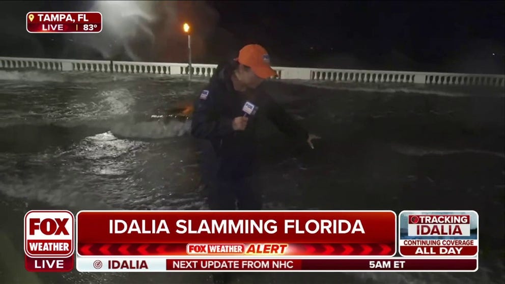
Flooding reported in Tampa as Hurricane Idalia nears Florida landfall
FOX Weather correspondent Nicole Valdes is in Tampa where flooding has been reported as Hurricane Idalia continues to gain strength as it near landfall in a matter of hours.
Leading up to landfall, Idalia produced rainfall that began to flood parts of Florida. In Charlotte County, which is located north of Fort Myers in southwest Florida, vehicles could be seen driving through shallow floodwater.
"Stay cautious out there – there (have) been reports of hydroplaning incidents on flooded roads," the Charlotte County Emergency Management warned in a Facebook post. "Brace yourself. More roads might end up flooded."
North of Charlotte County in Tampa, FOX Weather correspondent Nicole Valdes experienced rainfall from Idalia firsthand.
Images of heavy rain were also captured just south of Tampa, off the Palma Sola Causeway in Bradenton. On Tuesday night, officials responded to a person on a boat who was possibly in distress as rain and wind battered the shore.

Florida police respond to boat possibly in distress ahead of Idalia
Bradenton Police Department officers respond to a call about a person on a boat off the Palma Sola Causeway in southwestern Florida. Also on the scene were Manatee Search and Rescue and Manatee County Lifeguards. August 29, 2023. (Courtesy: @BradentonPD / X)
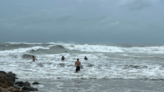
The first significant rain band of Idalia moved onshore in Florida on Tuesday evening, bringing heavy rain, 30-50 mph wind gusts and a few tornado warnings.
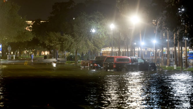
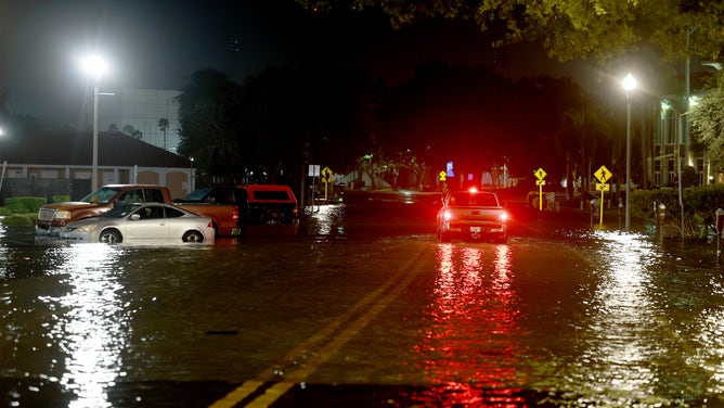
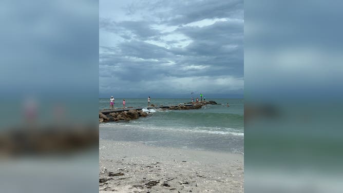
Life-threatening storm surge could reach 16 feet

(FOX Weather)
There is a major concern about life-threatening storm surge inundation along Florida’s Gulf Coast, where Storm Surge Warnings are in effect, including the Tampa Bay area and the Big Bend region.
The NHC warns that the deepest water will occur along the immediate coast in areas of onshore winds, where the storm surge will be accompanied by large and dangerous waves.
WHY IS STORM SURGE SO DANGEROUS?
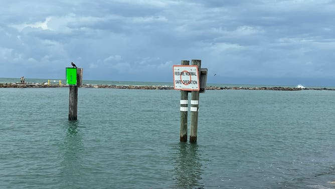
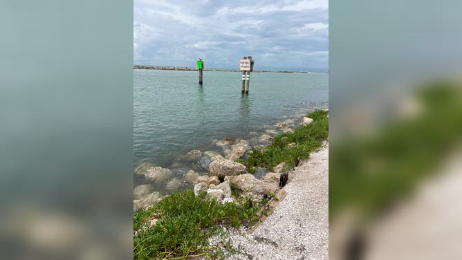
Storm surge coming onshore in Madeira Beach in southwestern Florida.
(@SheriffPinellas / X)
"Surge-related flooding depends on the relative timing of the surge and the tidal cycle and can vary greatly over short distances," the NHC said.
And with Hurricane Idalia still hours away from landfall, there are already reports of storm surge.
Police in Naples, Florida, have reported water covering several roads, and at least one underpass to Tin City has been completely flooded out.
Power outages climbing from Hurricane Idalia
(FOX Weather)
Power outages are starting to climb as ferocious Hurricane Idalia continues on its path toward the Florida coastline.
More than 100,000 outages have been reported so far, and that number is expected to climb as impacts from the hurricane continue.
Counties along Florida's Big Bend region appear to be the hardest-hit so far, but inland counties as well as locations to the south are also seeing power outage reports rising dramatically.
DeSantis said there were 25,000 line workers on standby in Florida on Monday to assist with power restoration efforts, and more were headed to the state. He estimates between 30,000 and 40,000 line workers will be able to respond to power outage reports in the wake of Hurricane Idalia.
‘Don’t mess around with this’
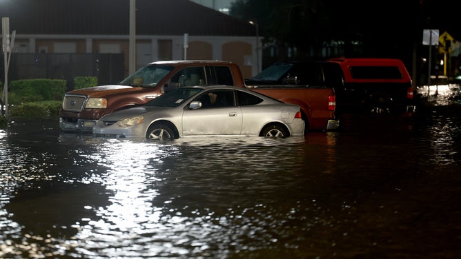
![ST PETERSBURG, FLORIDA - AUGUST 30: Vehicles sit in a flooded street caused by Hurricane Idalia passing offshore on August 30, 2023 in St. Petersburg, Florida. Hurricane Idalia is hitting the Big Bend area of Florida.]() Image 1 of 20
Image 1 of 20ST PETERSBURG, FLORIDA - AUGUST 30: Vehicles sit in a flooded street caused by Hurricane Idalia passing offshore on August 30, 2023 in St. Petersburg, Florida. Hurricane Idalia is hitting the Big Bend area of Florida. (Joe Raedle)
![ST PETERSBURG, FLORIDA - AUGUST 30: Vehicles sit in a flooded street caused by Hurricane Idalia passing offshore on August 30, 2023 in St. Petersburg, Florida. Hurricane Idalia is hitting the Big Bend area of Florida.]() Image 2 of 20
Image 2 of 20ST PETERSBURG, FLORIDA - AUGUST 30: Vehicles sit in a flooded street caused by Hurricane Idalia passing offshore on August 30, 2023 in St. Petersburg, Florida. Hurricane Idalia is hitting the Big Bend area of Florida. (Joe Raedle)
![ST PETERSBURG, FLORIDA - AUGUST 30: A vehicle drives through flood waters caused by Hurricane Idalia passing offshore on August 30, 2023 in St. Petersburg, Florida. Hurricane Idalia is hitting the Big Bend area of Florida.]() Image 3 of 20
Image 3 of 20ST PETERSBURG, FLORIDA - AUGUST 30: A vehicle drives through flood waters caused by Hurricane Idalia passing offshore on August 30, 2023 in St. Petersburg, Florida. Hurricane Idalia is hitting the Big Bend area of Florida. (Joe Raedle)
![ST PETERSBURG, FLORIDA - AUGUST 30: Flood waters caused by Hurricane Idalia passing offshore surround a building on August 30, 2023 in St. Petersburg, Florida. Hurricane Idalia is hitting the Big Bend area of Florida.]() Image 4 of 20
Image 4 of 20ST PETERSBURG, FLORIDA - AUGUST 30: Flood waters caused by Hurricane Idalia passing offshore surround a building on August 30, 2023 in St. Petersburg, Florida. Hurricane Idalia is hitting the Big Bend area of Florida. (Joe Raedle)
![A sign hangs on a window of a building ahead of Hurricane Idalia in Cedar Key, Florida, US, on Tuesday, Aug. 29, 2023. Hurricane Idalia is building strength in the Gulf of Mexico as it heads toward landfall Wednesday on Florida's west coast, where it threatens to unleash floods and trigger blackouts. Photographer: Christian Monterrosa/Bloomberg via Getty Images]() Image 5 of 20
Image 5 of 20A sign hangs on a window of a building ahead of Hurricane Idalia in Cedar Key, Florida, US, on Tuesday, Aug. 29, 2023. (Christian Monterrosa/Bloomberg)
![]() Image 6 of 20
Image 6 of 20The International Space Station flew over Idalia on Tuesday. (International Space Station)
![]() Image 7 of 20
Image 7 of 20Idalia already churned up large waves off Nokomis, Florida by 6 p.m. on Tuesday. (@acdaisy\_/X)
![]() Image 8 of 20
Image 8 of 20The afternoon high tide already started flooding Nokomis, Florida ahead of Idalia. (@acdaisy\_/X)
![]() Image 9 of 20
Image 9 of 20The afternoon high tide already started flooding Nokomis, Florida ahead of Idalia. (@acdaisy\_/X)
![]() Image 10 of 20
Image 10 of 20The afternoon high tide already started flooding Nokomis, Florida ahead of Idalia. ( )
![]() Image 11 of 20
Image 11 of 20The afternoon high tide already started flooding Nokomis, Florida ahead of Idalia. (@acdaisy\_/X)
![Residents fill sandbags to ward off flooding ahead of Hurricane Idalia in Indian Rocks, Florida, US, on Tuesday, Aug. 29, 2023. Hurricane Idalia is set to intensify into an extremely dangerous major storm, bringing life-threatening winds and floods, as it barrels north toward Floridas Gulf Coast. Photographer: Juan Manuel Barrero Bueno/Bloomberg via Getty Images]() Image 12 of 20
Image 12 of 20Residents fill sandbags to ward off flooding ahead of Hurricane Idalia in Indian Rocks, Florida, US, on Tuesday, Aug. 29, 2023. Hurricane Idalia is set to intensify into an extremely dangerous major storm, bringing life-threatening winds and floods, as it barrels north toward Floridas Gulf Coast. (Juan Manuel Barrero Bueno/Bloomberg)
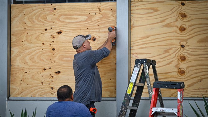
![CLEARWATER BEACH, FLORIDA - AUGUST 29: Nazih Tageddine wraps cellophane around his gas pump to prevent it from being damaged by the rain from Hurricane Idalia as it passes offshore on August 29, 2023 in Clearwater Beach, Florida. Hurricane Idalia is forecast to make landfall on the Gulf Coast of Florida Wednesday morning. (Photo by Joe Raedle/Getty Images)]() Image 13 of 20
Image 13 of 20Nazih Tageddine wraps cellophane around his gas pump to prevent it from being damaged by the rain from Hurricane Idalia as it passes offshore on August 29, 2023 in Clearwater Beach, Florida. (Joe Raedle)
![CLEARWATER BEACH, FLORIDA - AUGUST 29: Dave Bigham stands near the entrance to a 7-11 that has been boarded up to protect it from Hurricane Idalia on August 29, 2023 in Clearwater Beach, Florida. Hurricane Idalia is forecast to make landfall on the Gulf Coast of Florida Wednesday morning. (Photo by Joe Raedle/Getty Images)]() Image 14 of 20
Image 14 of 20Dave Bigham stands near the entrance to a 7-11 that has been boarded up to protect it from Hurricane Idalia on August 29, 2023 in Clearwater Beach, Florida. (Joe Raedle)
![Workers set up a fence to prevent flooding at Tampa General Hospital in Tampa, Florida, on August 29, 2023 as the city prepares for Hurricane Idalia. Hurricane Idalia intensified Tuesday as it churned toward the west coast of Florida, triggering mass evacuation orders and flood alerts as authorities warned of life-threatening ocean surge and catastrophic destruction when the storm rages ashore early Wednesday. (Photo by Miguel J. Rodriguez Carrillo / Miguel J. Rodriguez Carrillo / AFP) (Photo by MIGUEL J. RODRIGUEZ CARRILLO/Miguel J. Rodriguez Carrillo/AFP via Getty Images)]() Image 15 of 20
Image 15 of 20Workers set up a fence to prevent flooding at Tampa General Hospital in Tampa, Florida, on August 29, 2023 as the city prepares for Hurricane Idalia. (Miguel J. Rodriguez Carrillo/AFP )
![People stock up on food and water in Tampa, Florida, on August 29, 2023 as the city prepares for Hurricane Idalia. Hurricane Idalia intensified Tuesday as it churned toward the west coast of Florida, triggering mass evacuation orders and flood alerts as authorities warned of life-threatening ocean surge and catastrophic destruction when the storm rages ashore early Wednesday. (Photo by Miguel J. Rodriguez Carrillo / Miguel J. Rodriguez Carrillo / AFP) (Photo by MIGUEL J. RODRIGUEZ CARRILLO/Miguel J. Rodriguez Carrillo/AFP via Getty Images)]() Image 16 of 20
Image 16 of 20People stock up on food and water in Tampa, Florida, on August 29, 2023 as the city prepares for Hurricane Idalia. (Miguel J. Rodriguez Carrillo/AFP)
![People board up a window in Tampa, Florida, on August 29, 2023 as the city prepares for Hurricane Idalia. Hurricane Idalia intensified Tuesday as it churned toward the west coast of Florida, triggering mass evacuation orders and flood alerts as authorities warned of life-threatening ocean surge and catastrophic destruction when the storm rages ashore early Wednesday. (Photo by Miguel J. Rodriguez Carrillo / Miguel J. Rodriguez Carrillo / AFP) (Photo by MIGUEL J. RODRIGUEZ CARRILLO/Miguel J. Rodriguez Carrillo/AFP via Getty Images)]() Image 17 of 20
Image 17 of 20People board up a window in Tampa, Florida, on August 29, 2023 as the city prepares for Hurricane Idalia. Hurricane Idalia intensified Tuesday as it churned toward the west coast of Florida, triggering mass evacuation orders and flood alerts as authorities warned of life-threatening ocean surge and catastrophic destruction when the storm rages ashore early Wednesday. (Miguel J. Rodriguez Carrillo/AFP)
![]() Image 18 of 20
Image 18 of 20ST. PETERSBURG BEACH, FLORIDA - AUGUST 29: A surfer rides the waves kicked up by Hurricane Idalia as it approaches offshore on August 29, 2023 in St. Petersburg Beach, Florida. Hurricane Idalia is forecast to track toward the Gulf Coast of Florida. (Photo by Joe Raedle/Getty Images) (oe Raedle)
![]() Image 19 of 20
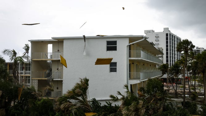
Image 19 of 20Debris flies off a roof ahead of Hurricane Idalia in Fort Myers, Florida, US, on Tuesday, Aug. 29, 2023. Hurricane Idalia is building strength in the Gulf of Mexico as it heads toward landfall Wednesday on Florida's west coast, where it threatens to unleash floods and trigger blackouts. Photographer: Eva Marie Uzcategui/Bloomberg via Getty Images (Eva Marie Uzcategui/Bloomberg)
![]() Image 20 of 20
Image 20 of 20Water on the shelves is running low at a Target in Winter Garden, Florida, as Hurricane Idalia makes its way north in the Gulf of Mexico towards Florida on Tuesday, Aug. 29, 2023. (Rich Pope/Orlando Sentinel/Tribune News Service via Getty Images) (Rich Pope/Orlando Sentinel/Tribune News Service)


The National Weather Service in Tallahassee issued an ominous warning in its forecast Tuesday morning and urged residents to complete preparations ahead of Hurricane Idalia.
"To put this storm into historical context, there are no major hurricanes in the historical dataset going back to 1851 that have tracked into Apalachee Bay," the NWS said. "None. Don’t mess around with this."
Resources have been prepositioned across areas expected to be impacted by Hurricane Idalia, including more than 5,500 National Guard troops, search and rescue teams, and hundreds of Starlink internet dishes.
President Joe Biden on Monday approved Florida’s request for a pre-landfall emergency declaration, and the state’s Emergency Operations Center is now operating at Level 1, which means a 24-hour operation until the storm threat passes.
KNOW YOUR ZONE: FLORIDA EVACUATION MAP SHOWS WHO WILL HAVE TO LEAVE BEFORE A HURRICANE STRIKES
Major travel disruptions anticipated
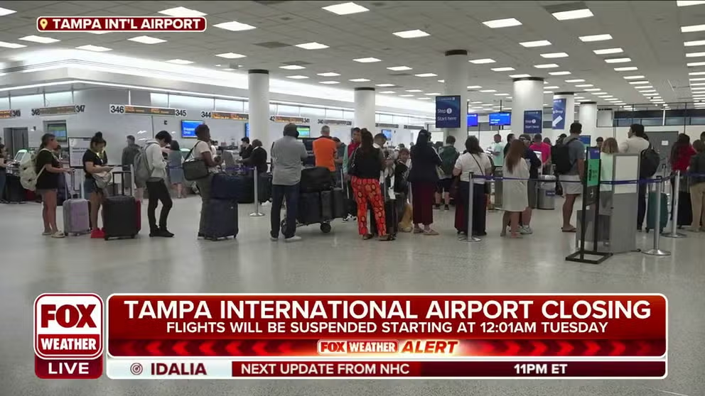
Potential travel nightmare with airport closures in Florida due to Idalia
Comercial pilot Kathleen Bangs joins FOX Weather to talk about the impacts Idalia will have on the airlines and airports.
Major Florida airports closed due to Hurricane Idalia on Tuesday, including Tampa International Airport, St. Petersburg/Clearwater International Airport and Tallahassee International Airport. Additional flight disruptions are expected into and out of Florida.
United Airlines announced that it was adding additional flights from Orlando (MCO) and Sarasota (SRQ) to help with the evacuation of travelers from the area.
In addition, SunRail service in Orlando has been suspended until further notice.
The Florida Department of Transportation also began to close bridges as wind speeds began to increase.
DOWNLOAD THE FREE FOX WEATHER APP
Where is Hurricane Idalia right now?

(FOX Weather)
Hurricane Idalia is located about 55 miles northwest of Cedar Key and 65 miles south-southeast of Tallahassee, and maximum sustained winds decreased slightly to 125 mph. Hurricane Idalia is moving to the north-northeast at 18 mph.
"Catastrophic storm surge and destructive winds expected in the Florida Big Bend region this morning when Idalia moves inland," the NHC said.
Where is Hurricane Idalia going?

(FOX Weather)
WHAT TO DO WHEN HURRICANE OR TROPICAL STORM WATCHES AND WARNINGS ARE ISSUED FOR YOUR TOWN
On that forecast track, the center of Idalia will reach the Gulf Coast of Florida within the Hurricane Warning area on Wednesday and move closer to the coast of the Carolinas on Thursday.
What watches/warnings are in effect for Hurricane Idalia?

(FOX Weather)
A Hurricane Warning is in effect for:
- The middle of Longboat Key northward to Indian Pass, including Tampa Bay
- Altamaha Sound, Georgia to Edisto Beach, South Carolina
A Hurricane Watch is in effect for:
- Mouth of St. Mary's River north to Altamaha Sound
- Edisto Beach, South Carolina to South Santee River, South Carolina
A Tropical Storm Warning is in effect for:
- Chokoloskee northward to the Middle of Longboat Key
- West of Indian Pass to Mexico Beach
- Sebastian Inlet Florida to Surf City, North Carolina
- North of Surf City to the North Carolina/Virginia border, and Pamlico and Albemarle Sounds

(FOX Weather)
A Storm Surge Warning is in effect for:
- Englewood northward to Indian Pass, including Tampa Bay
- St. Catherine's Sound to South Santee River
A Storm Surge Watch is in effect for:
- Bonita Beach northward to Englewood, including Charlotte Harbour
- Neuse and Pamlico Rivers North Carolina
- Beaufort Inlet to Drum Inlet North Carolina
- Mouth of the St. Mary's River to South Santee River South Carolina
Read more about the differences between these critical watches and warnings.
Storm surge could reach the following heights:
- Wakulla/Jefferson County line, Florida to Yankeetown, Florida: 12-16 feet
- Yankeetown to Chassahowitzka, Florida: 7-11 feet
- Chassahowitzka to Anclote River, Florida: 6-9 feet
- Tampa Bay: 4-6 feet
- Middle of Longboat Key, Florida to Englewood, Florida: 3-5 feet
- Charlotte Harbor: 2-4 feet
- Flagler/Volusia County Line to the mouth of the St. Mary River: 1-3 feet
- Florida Keys: 1-2 feet
What are the rainfall and flooding impacts from Hurricane Idalia?

(FOX Weather)
Areas of the west coast of Florida, the Florida Panhandle, southeastern Georgia and the eastern Carolinas can expect to see between 4–8 inches of rain between Tuesday and Thursday. Locally higher amounts of up to 12 inches are also possible, primarily near where Hurricane Idalia makes landfall.
WATER FROM HURRICANES, TROPICAL STORMS KILLS MORE IN U.S. THAN WIND
The torrential rainfall may lead to life-threatening flash and urban flooding across portions of the west coast of Florida, the Florida Panhandle and southern Georgia from Tuesday into Wednesday and then spreading into portions of the eastern Carolinas Wednesday into Thursday.
What are the hurricane-force wind impacts from Hurricane Idalia?

(FOX Weather)
The NHC is warning of the potential for destructive, life-threatening winds where the eye of Hurricane Idalia moves onshore in the Big Bend region of Florida, with hurricane conditions expected elsewhere in portions of the Hurricane Warning area along Florida's Gulf Coast.
Strong winds will also likely spread inland across portions of northern Florida and southern Georgia near the track of the center of Idalia, where Hurricane Warnings are in effect.
Residents there should prepare for long-duration power outages.