Harold weakens to tropical depression after dumping torrential rain on Texas
Tropical Storm Harold was downgraded and lost the force of its punch, but heavy rains continue to fall across Texas.
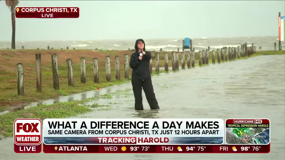
Flooding in Corpus Christi and more rain to come
FOX Weather's Katie Byrne was in the storm surge from Tropical Storm Harold. She found a few beachcombers while the storm made landfall. Meteorologist Marissa Torres tells us how much more rain Texas could see.
What was Tropical Storm Harold has weakened to a tropical depression Tuesday as it moves farther inland, dropping inches of rain across South Texas along the way.
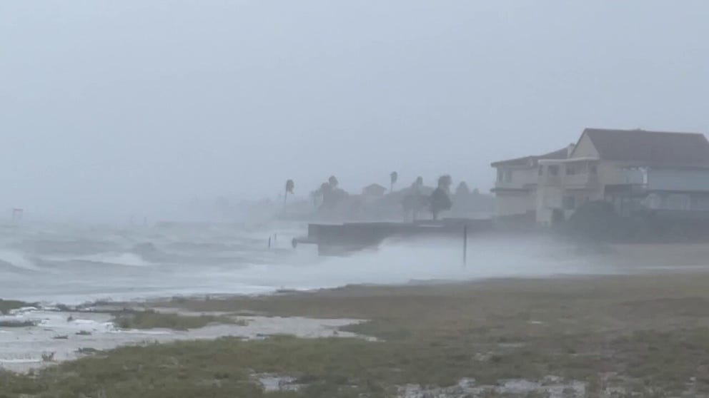
Harold made landfall on Padre Island late Tuesday morning as a tropical storm with torrential rain, strong winds and large waves battering the coast. Worries of flash flooding and tornadoes continued as the storm moved inland.
Meteorologist Jason Frazer tried to stand up to the wind and rain on Padre Island but conditions made it almost impossible to hear him.
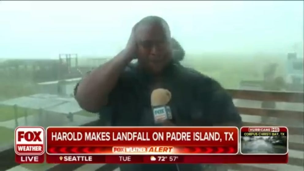
Watch: Tropical Storm Harold versus Jason Frazer
Meteorologist Jason Frazer stood up to the winds and the rain as Tropical Storm Harold made landfall.
The National Weather Service recorded wind gusts of 65 mph at Corpus Christi and a 67 mph gust at Loyola Beach – both solidly within tropical-storm criteria. Corpus logged 5.42 inches of rainfall and Portland, 5.15 inches.
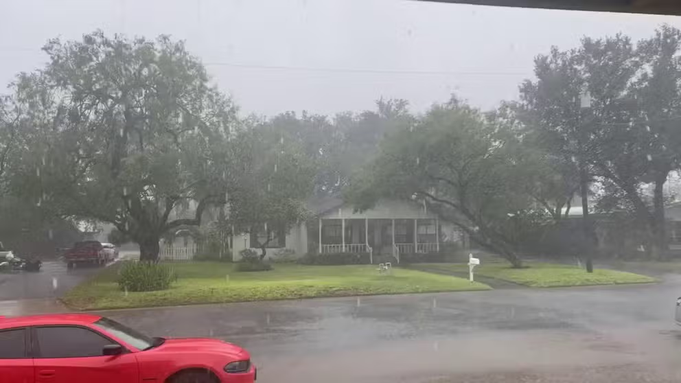
Rain batters Tropical Storm Warned area of South Texas
Heavy rain and strong winds struck Falfurrias, Texas Tuesday as a Tropical Storm Warning was in effect.
Where is Harold?
Tropical Storm Harold is now about 15 miles east of Laredo, Texas, and is moving west-northwest at 21 mph. The storm has maximum sustained winds of 35 mph with higher gusts.
GUIDE FOR 2023 ATLANTIC HURRICANE SEASON
(FOX Weather)
What are the expected impacts of Tropical Storm Harold?
Tropical Storm Harold is expected to bring much-needed rain to the South Texas area through Wednesday, according to the FOX Forecast Center. Rainfall amounts of 2-3 inches, with locally higher amounts of about 3-5 inches across South Texas are possible through early Wednesday.
The heavy rainfall may produce areas of flash and urban flooding.

(FOX Weather)
Harold's remnants will also bring moisture to much of the Southwest through the end of the workweek.

(FOX Weather)
New Mexico, Arizona and Utah all have a flood threat Wednesday into Thursday as the system continues into the region.

(FOX Weather)
HERE ARE THE HURRICANE NAMES FOR THE 2023 ATLANTIC SEASON
Texas State Emergency Operations Center activated
Watch: Tropical Storm Harold makes landfall in South Texas
Video shows deteriorating conditions in South Texas as Tropical Storm Harold makes landfall with maximum sustained winds of 50 mph and produces heavy rain and large waves along the coast.
Preparations were made across the region as Tropical Storm Harold spun across the western Gulf of Mexico on a path toward the Lone Star State.
Schools in Santa Gertrudis, Texas, were closed ahead of Harold’s arrival. And out of an abundance of caution, all Texas A&M University-Kingsville locations, including the Citrus Center in Weslaco suspended normal operations at 8 a.m. CDT Tuesday.
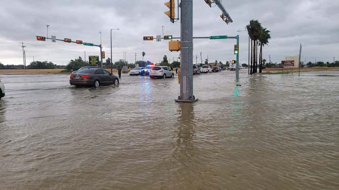
In addition to schools, roads across the region were also closed due to flooding.
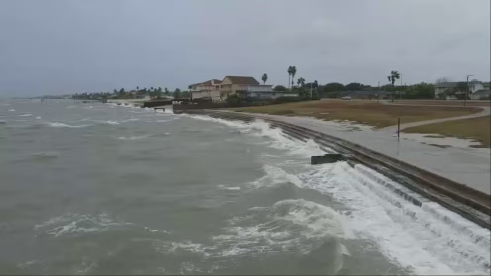
Drone video of waves crashing on the Corpus Christi seawall
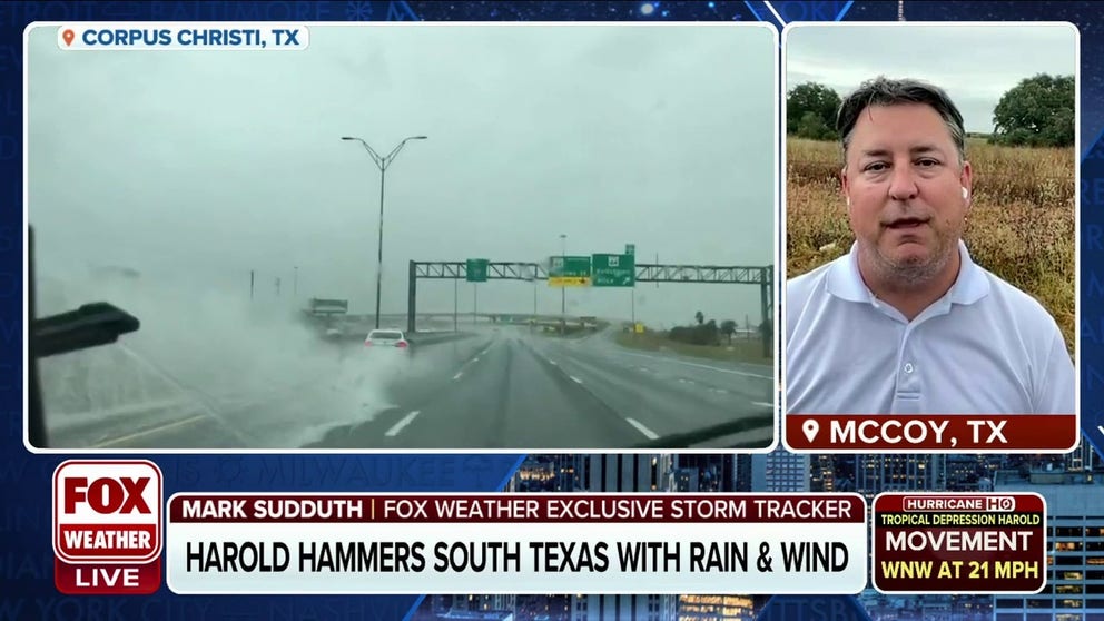
FOX Weather's Exclusive Storm Tracker Mark Sudduth captured drone video of waves crashing on the Corpus Christi seawall before Tropical Storm Harold's landfall.
According to the Corpus Christi Police Department, Harbor Bridge Project crews were forced to close the Northwest Loop Ramp connecting to southbound SH 286 (Crosstown Expressway). Flooding also forced the closure of the Northwest Loop Ramp connecting southbound SH 286, and drivers in the area needed to be detoured around the flooding.
FOX Weather's Exclusive Storm Tracker witnessed an accident on a flooded highway in Corpus between live reports.
Commuter nightmare courtesy of Tropical Storm Harold
FOX Weather's Exclusive Storm Tracker Mark Suddath caught a car hydroplaning and spinning out in between live reports.
The Laredo Police Department listed roads closed by flooding on social media. They made a plea on Facebook to stay home. An officer stated that police and fire had to perform deep water rescues for several vehicles and drivers that started floating in the floodwater.
The Laredo Police warned commuters to avoid flooded roads.
(Laredo Police Department / FOX Weather)
Critical fire weather conditions remain where Harold misses
Many drought-stricken areas of Texas to miss out on Tropical Storm Harold's rain
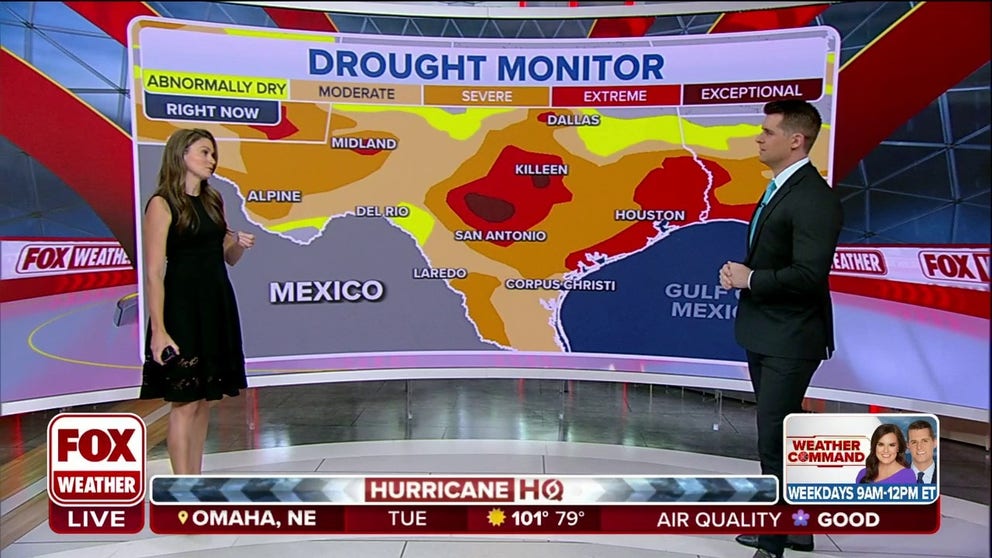
While parts of South Texas may get a little too much rain from Tropical Storm Harold, drought-stricken areas just to the north of the storm are looking south with jealous eyes.
While parts of South Texas may get a little too much rain from Tropical Storm Harold, drought-stricken areas just to the north of the storm are looking south with jealous eyes.
"The tough thing when it comes to Harold is the spots that really needed (the rain): San Antonio, Austin, Houston and Dallas -- so close, yet so far away," said FOX Weather Meteorologist Britta Merwin. "Folks in Southeast Texas and Hill Country; they were so excited there was going to be a weak tropical storm to bring them rain, and they’re going to be left out."
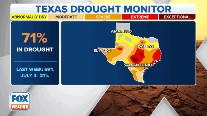
Current drought conditions in Texas.
(FOX Weather)
Much of Texas is in some level of drought, and it’s been weeks since it’s rained in Dallas and San Antonio.
Areas to the north of Harold may see a little rain Tuesday, "but not like what we’re going to see in South Texas," Merwin said. "When you’re facing extreme drought conditions from the Hill Country and Southeast Texas into North Texas these are areas that could be facing huge wildfire risks in the next 4-6 weeks if they don’t get rain and unfortunately, they are missing out, and they are missing out by such a close margin."
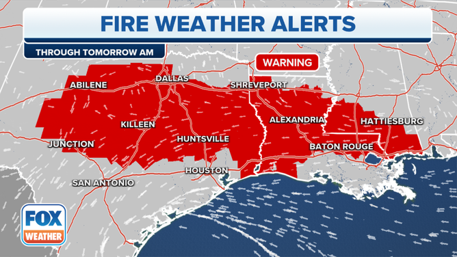
Fire Weather Alerts in effect on Tuesday, August 22, 2023.
(FOX Weather)
To illustrate the dichotomy, critical fire weather conditions are forecast Tuesday for parts of Texas just north of Harold’s expected trek across the southern border Tuesday.
Fire Weather Warnings are in effect for a large swath of central and east Texas as hot and dry conditions outside Harold’s rain bands combine with a period of gusty winds as the tropical storm passes by to the south to bring dangerous conditions ripe for rapid spread should any fire begin.