Tornadoes damage homes in Arkansas, Oklahoma as severe weather tears across central US
Radar showed a large debris signature near the community of Greenland in Arkansas, which appeared to have taken a direct hit from a tornado.

Tornadoes damage homes in Arkansas, Oklahoma
Powerful storms raced across the central U.S. on Monday, and likely tornadoes caused damage to homes in Arkansas and Oklahoma. FOX Weather Meteorologist Marissa Torres has the latest on May 20, 2025.
Fast Facts:
- A tornado caused significant damage in Washington County, Arkansas, and a State of Emergency has been declared.
- Powerful storms produced tornadoes in Nebraska and Oklahoma on Monday.
- No injuries or fatalities have been reported.
GREENLAND, Ark. – Emergency crews have been spread out across portions of Arkansas and Oklahoma as relentless rounds of severe weather and tornadoes blasted the region on Monday, damaging homes and knocking out power.
Monday’s extreme weather threat came as America’s heartland continues recovery efforts after deadly storms slammed communities in Kentucky and Missouri, including St. Louis, over the weekend.
Some of those same areas face the possibility of more severe weather Tuesday.
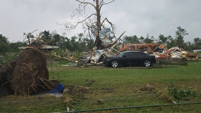
This image shows damage to trees and a home near Pittsburg, Oklahoma, on Monday, May 19, 2025.
(Zack Jones/@Holytornado2185/X / FOX Weather)
Kansas, too, saw strong, damaging tornadoes early Monday morning before the threat shifted to Oklahoma, Arkansas and Nebraska.
DOWNLOAD THE FREE FOX WEATHER APP

Greenland, Arkansas, appears to take direct hit from tornado
FOX Weather Meteorologist Steve Bender talks about a large debris signature that appeared on radar as an apparent tornado hit the town of Greenland, Arkansas.
On Monday evening, radar showed a large debris signature near the community of Greenland in Arkansas, which appeared to have taken a direct hit from a tornado. The tornado then continued toward the Fayetteville area before lifting.
"Wow! That is not a good sign. We have a very apparent debris ball, this very stark blue (on radar)," FOX Weather Meteorologist Steve Bender said as he tracked the tornado Monday night. "This is moving at an astonishing pace."
SEE IT: AERIAL VIDEO SHOWS DAMAGE IN LONDON, KENTUCKY AFTER DEVASTATING TORNADO
![Damage is seen in Washington County, Arkansas, after severe weather and tornadoes on Monday, May 19, 2025.]() Image 1 of 8
Image 1 of 8Damage is seen in Washington County, Arkansas, after severe weather and tornadoes on Monday, May 19, 2025. (Washington County Sheriff's Office/Facebook)
![Damage is seen in Washington County, Arkansas, after severe weather and tornadoes on Monday, May 19, 2025.]() Image 2 of 8
Image 2 of 8Damage is seen in Washington County, Arkansas, after severe weather and tornadoes on Monday, May 19, 2025. (Washington County Sheriff's Office/Facebook)
![Damage is seen in Washington County, Arkansas, after severe weather and tornadoes on Monday, May 19, 2025.]() Image 3 of 8
Image 3 of 8Damage is seen in Washington County, Arkansas, after severe weather and tornadoes on Monday, May 19, 2025. (Washington County Sheriff's Office/Facebook)
![Damage is seen in Washington County, Arkansas, after severe weather and tornadoes on Monday, May 19, 2025.]() Image 4 of 8
Image 4 of 8Damage is seen in Washington County, Arkansas, after severe weather and tornadoes on Monday, May 19, 2025. (Washington County Sheriff's Office/Facebook)
![Damage is seen in Washington County, Arkansas, after severe weather and tornadoes on Monday, May 19, 2025.]() Image 5 of 8
Image 5 of 8Damage is seen in Washington County, Arkansas, after severe weather and tornadoes on Monday, May 19, 2025. (Washington County Sheriff's Office/Facebook)
![Damage is seen in Washington County, Arkansas, after severe weather and tornadoes on Monday, May 19, 2025.]() Image 6 of 8
Image 6 of 8Damage is seen in Washington County, Arkansas, after severe weather and tornadoes on Monday, May 19, 2025. (Washington County Sheriff's Office/Facebook)
![Damage is seen in Washington County, Arkansas, after severe weather and tornadoes on Monday, May 19, 2025.]() Image 7 of 8
Image 7 of 8Damage is seen in Washington County, Arkansas, after severe weather and tornadoes on Monday, May 19, 2025. (Washington County Sheriff's Office/Facebook)
![Damage is seen in Washington County, Arkansas, after severe weather and tornadoes on Monday, May 19, 2025.]() Image 8 of 8
Image 8 of 8Damage is seen in Washington County, Arkansas, after severe weather and tornadoes on Monday, May 19, 2025. (Washington County Sheriff's Office/Facebook)


The Washington County Sheriff’s Office said trees have been knocked down across the area, and damage was reported within the city of Greenland, as well as smaller communities in the area off of Campbell Loop, Smokey Lane and in the Lincoln area.
Despite the tornado, the sheriff’s office said there have been no reports of injuries in the county.
On Monday, Washington County officials declared a state of emergency, which now enables the county to expedite emergency response efforts and request additional resources from the state and federal governments if eligible.

Tornado spotted in northwestern Arkansas
A driver on Interstate 49 in Greenland, Arkansas, spots an apparent tornado in the distance on Monday.
"Our top priority is the safety of our residents," Washington County Judge Patrick Deakins said. "County crews, emergency responders, and utility teams are working around the clock to assess the damage and restore critical services. This declaration ensures we can respond quickly and effectively to the needs of our communities."
City officials in Fayetteville told FOX Weather that the city did experience some localized flooding and scattered power outages during the severe weather Monday. No injuries or swift water rescues were reported, and emergency crews are continuing to assess storm impacts.
In addition, the city sent first responders to Greenland to help with recovery efforts there.
Intense storms slam Oklahoma, Nebraska

Tornado charging near North Bend, Nebraska
A tornado was spotted near North Bend, Nebraska on Monday evening as severe storms threatened much of the Central U.S.
Powerful thunderstorms also impacted communities in Nebraska and Oklahoma on Monday.
The National Weather Service office in Omaha, Nebraska, reported a tornado on the ground near Rogers that was headed toward North Bend.
Video from a storm chaser Monday showed the tornado moving near North Bend.

People in Pittsburg, Oklahoma, stop on the road to remove a downed branch on a powerline
The National Weather Service issued a tornado and flood watch in the area as the severe weather continues.
According to storm reports and photos, another suspected tornado caused damage near the community of Pittsburg, Oklahoma.
Video recorded near Savanna, Oklahoma, showed winds and rain impacting Department of Transportation cameras on Highway 69 during the tornado-warned storm.
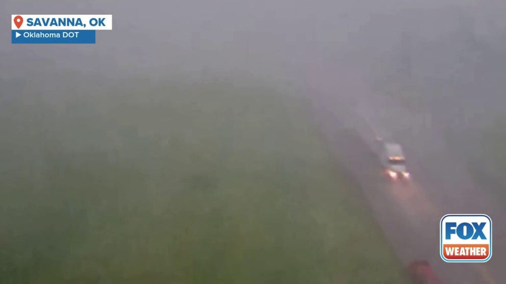
Tornado-warned storm rocks southeast Oklahoma
Video taken on U.S. Highway 69 shows gusting winds and heavy rain from a tornado-warned storm near Savanna, Oklahoma.