Tornadoes rip roofs from buildings, snap trees as severe storms slam US from Southeast to Ohio Valley
Confirmed tornado touchdowns were reported in Alabama, Tennessee and Illinois on Tuesday evening as widespread severe thunderstorms triggered dozens of Tornado Warnings.

Severe storms slam Georgia communities overnight
Powerful storms slammed areas of the South and Southeast on Tuesday evening and Wednesday morning, causing some damage to local communities. FOX 5 Atlanta Reporter Marc Teichner joined FOX Weather on Wednesday morning with the latest information as he was touring storm damage in the area.
HUNTSVILLE, Ala. – Multiple tornadoes slammed communities from the mid-Mississippi and lower Ohio valleys through the Southeast once again Tuesday and into early Wednesday morning, causing damage to homes and businesses as severe thunderstorms barreled across those regions.
This marked the eighth consecutive day that severe weather caused widespread damage after an eerily quiet start to May, which is typically the peak month for tornadoes in the U.S.
![Tornado near Athens, Alabama]() Image 1 of 7
Image 1 of 7Tornado reported near Athens, Alabama on May 20, 2025. (Andrew Gwin / @andrewgwin / X)
![Tornado near Madison, Alabama]() Image 2 of 7
Image 2 of 7Tornado near Madison, Alabama on May 20, 2025. (Joe Jones / @joeandhisdrone / X)
![Tornado near Madison, Alabama on May 20, 2025.]() Image 3 of 7
Image 3 of 7Tornado near Madison, Alabama on May 20, 2025. (Joe Jones / @joeandhisdrone / X)
![Tornado damage in Athens, Alabama]() Image 4 of 7
Image 4 of 7Utility poles sit toppled after a tornado swept through Athens, Alabama on May 20, 2025. (City of Athens, Alabama)
![This image shows trees down across Reinhardt College Parkway in Cherokee County, Georgia, after severe weather on May 21, 2025.]() Image 5 of 7
Image 5 of 7This image shows trees down across Reinhardt College Parkway in Cherokee County, Georgia, after severe weather on May 21, 2025. (Cherokee Sheriff's Office/Facebook)
![This image shows wires down across a roadway in Gordon County, Georgia, after severe weather on May 21, 2025.]() Image 6 of 7
Image 6 of 7This image shows wires down across a roadway in Gordon County, Georgia, after severe weather on May 21, 2025. (Gordon County Sheriff's Office/Facebook)
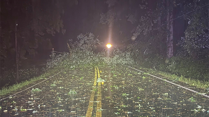
![This image shows trees down across a road after severe weather in Gordon County, Georgia, on May 21, 2025.]() Image 7 of 7
Image 7 of 7This image shows trees down across a road after severe weather in Gordon County, Georgia, on May 21, 2025. (Gordon County Sheriff's Office/Facebook)


Confirmed tornado touchdowns were reported in Alabama, Tennessee and Illinois on Tuesday evening as widespread severe thunderstorms triggered dozens of Tornado Warnings.

A large tornado was spotted in Athens, Alabama, on Tuesday evening
The National Weather Service issued an ongoing tornado watch into the late night hours.
A rare Tornado Emergency was briefly issued for the Huntsville and Madison areas of Alabama late Tuesday afternoon because of a confirmed large and destructive tornado on the ground.

Watch: Vivid lightning shoots from clouds during tornado-warned thunderstorm in Alabama
A video shared from Grant, Alabama, shows vivid lightning shooting from the clouds during a tornado-warned thunderstorm on May 20, 2025.
The tornado appeared to have faded before reaching the heart of Huntsville, and the Tornado Emergency was eventually allowed to expire.

Alabama tornado spotted live on FOX Weather
A tornado was seen near tornado-warned Scottsboro, Alabama, on Tuesday night.
The tornado was spotted on the ground west of Huntsville, near Madison and Athens.
Damage was reported in Athens, where photos showed numerous power poles snapped by the ferocious winds.
Video shows tornado ripping roof from Tennessee building

Tornado spotted tearing roof off building near airport in Jackson, Tennessee
A tornado swept through the area near Jackson, Tennessee's airport Tuesday evening amid a severe weather threat covering 60 million people.
Another tornado was spotted near Jackson, Tennessee, on Tuesday, where it caused damage to buildings and warehouses near the airport.
A video shared by the Tennessee Highway Patrol shows debris being lofted into the air after the storm tore the roof off a nearby factory as troopers and staff were seeking shelter for safety.
No injuries were reported, and troopers were back out in the community a few minutes later to help those impacted by the storm.

Tornado touches down near Jackson, Tennessee, airport
Video shows a tornado causing damage when it touched down near the airport in Jackson, Tennessee, on Tuesday.
Another tornado was spotted to the north near Springfield, Illinois, which triggered a Tornado Warning for the city.
Employees inside the Illinois State Capitol building in Springfield were told to seek shelter in the lowest levels of the facility as the tornado-warned storm approached the area.
As FOX Weather was on the phone with an employee inside the building, she could hear an emergency alert being broadcast on a public address system in the background, urging people to head to basements and to stay away from windows.
Southeast slammed by severe weather overnight and into early Wednesday

This image shows trees down across a road after severe weather in Gordon County, Georgia, on May 21, 2025.
(Gordon County Sheriff's Office/Facebook / FOX Weather)
The storms then swept into the Southeast, including Georgia, triggering numerous Severe Thunderstorm Warnings and Tornado Warnings.
The Gordon County Sheriff’s Office said numerous trees and power lines were brought down during the extreme weather, and at least one storm-related crash occurred.
The sheriff’s office warned drivers that they should be aware of the possibility of debris in the roadways and to exercise caution.
This image shows trees down across Reinhardt College Parkway in Cherokee County, Georgia, after severe weather on May 21, 2025.
(Cherokee Sheriff's Office/Facebook / FOX Weather)
Numerous trees and power lines were also brought down in Cherokee County, Georgia.
The sheriff’s office said Reinhardt College Parkway, west of Land Road, was shut down due to the fallen trees and power lines, and people were asked to avoid the area.