Extensive damage reported after nighttime Kansas tornadoes, train derailment amid rare Tornado Emergency
Officials said a tornado moved through the city of Plevna, Kansas, damaging several homes, trees and utility poles. The National Weather Service office in Wichita had issued a Tornado Emergency for Plevna, Sylvia and Abbyville early Monday morning.

Nighttime tornadoes slam Kansas towns damaging homes, derailing train
Dangerous nighttime tornadoes were reported across western Kansas, with twisters reportedly damaging homes and derailing a train. FOX Weather Meteorologists Kendall Smith and Marissa Torres have the latest on May 19, 2025.
PLEVNA, Kan. – Significant damage was reported in western and central Kansas early Monday morning after powerful storms produced tornadoes that damaged numerous homes and brought down trees and power lines amid a rare Tornado Emergency.
According to Reno County Emergency Management, emergency responders, public works and utility crews have been actively assessing the situation after a tornado touched down just before midnight and moved through several rural portions of the county.
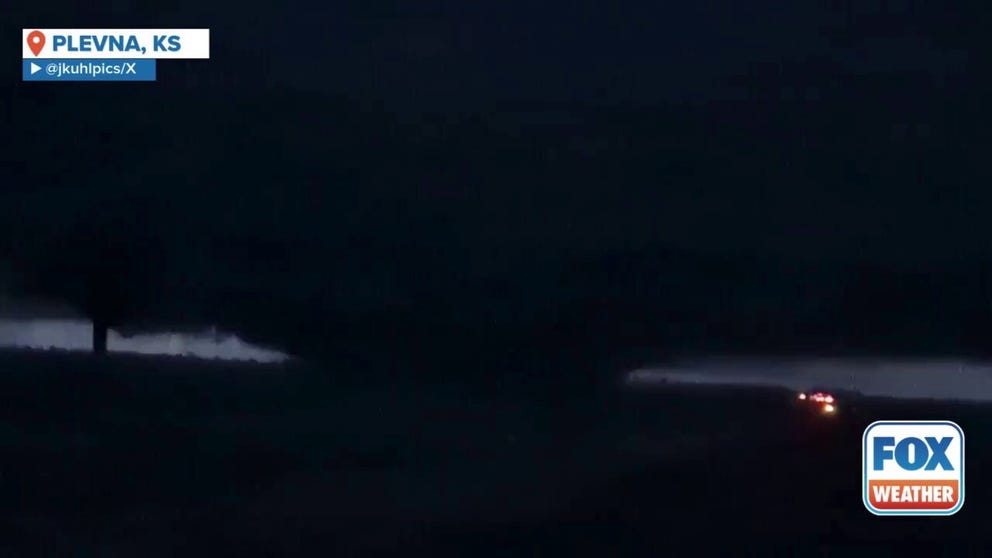
Watch: Massive wedge tornado approaches Plevna, Kansas
A video shared from Plevna, Kansas, shows a massive wedge tornado being illuminated by flashes of lightning as it spins across the landscape on Monday, May 19.
Officials said the tornado then moved through the city of Plevna, Kansas, damaging several homes, trees and utility poles.
Residents have been urged to avoid areas impacted by the tornado to allow emergency crews time to conduct damage assessments.
"We are thankful the residents took shelter immediately when the Tornado Warnings were issued," officials said. "While the damage is extensive, we are relieved that no injuries or fatalities have been reported."
The National Weather Service office in Wichita, Kansas, had issued a Tornado Emergency for the city of Plevna, as well as for Sylvia and Abbyville, early Monday morning.
DOWNLOAD THE FREE FOX WEATHER APP
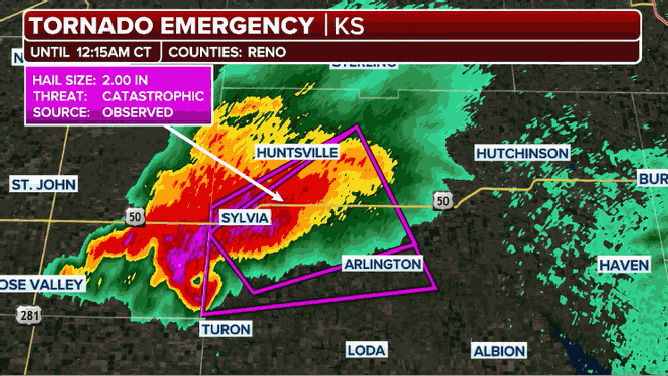
This animated image shows a radar loop during a Tornado Emergency in Kansas on Monday, May 19, 2025.
(FOX Weather)
"The Tornado Warning for Reno County has been canceled. However, it sounds like Plevna took a direct hit with the tornado," police in Hutchinson said. "First responders are currently in the area looking for injured and assessing damage. Please keep Plevna in your thoughts."
In Stafford County, officials said that the storms took 911 lines down, and residents were advised that calls were being routed through Pawnee County.
Officials said they were working to restore 911 service as quickly as possible.
DAMAGE ASSESSMENTS CONTINUE IN KENTUCKY, MISSOURI IN WAKE OF DEADLY TORNADO OUTBREAK
![This image shows a damaged vehicle after a tornado in Grinnell, Kansas.]() Image 1 of 10
Image 1 of 10This image shows a damaged vehicle after a tornado in Grinnell, Kansas. (Jamie Church)
![This image shows a damaged vehicle after a tornado in Grinnell, Kansas.]() Image 2 of 10
Image 2 of 10This image shows a damaged vehicle after a tornado in Grinnell, Kansas. (Jamie Church)
![This image shows a damaged vehicle after a tornado in Grinnell, Kansas.]() Image 3 of 10
Image 3 of 10This image shows a damaged vehicle after a tornado in Grinnell, Kansas. (Jamie Church)
![This image shows a damaged vehicle after a tornado in Grinnell, Kansas.]() Image 4 of 10
Image 4 of 10This image shows a damaged vehicle after a tornado in Grinnell, Kansas. (Jamie Church)
![This image shows a train that was derailed during a Tornado Emergency in Greensburg, Kansas.]() Image 5 of 10
Image 5 of 10This image shows a train that was derailed during a Tornado Emergency in Greensburg, Kansas. (@madelynn_wx/X)
![This image shows a train that was derailed during a Tornado Emergency in Greensburg, Kansas.]() Image 6 of 10
Image 6 of 10This image shows a train that was derailed during a Tornado Emergency in Greensburg, Kansas. (@madelynn_wx/X)
![This photo shows damage from a tornado in Grinnell, Kansas, on Sunday, May 18, 2025.]() Image 7 of 10
Image 7 of 10This photo shows damage from a tornado in Grinnell, Kansas, on Sunday, May 18, 2025. (@AndrewR3132/X)
![This photo shows damage from a tornado in Grinnell, Kansas, on Sunday, May 18, 2025.]() Image 8 of 10
Image 8 of 10This photo shows damage from a tornado in Grinnell, Kansas, on Sunday, May 18, 2025. (@AndrewR3132/X)
![This photo shows damage from a tornado in Grinnell, Kansas, on Sunday, May 18, 2025.]() Image 9 of 10
Image 9 of 10This photo shows damage from a tornado in Grinnell, Kansas, on Sunday, May 18, 2025. (@AndrewR3132/X)
![A tornado seen near Bennett, Colorado on May 18, 2025.]() Image 10 of 10
Image 10 of 10A tornado seen near Bennett, Colorado on May 18, 2025. (@tayagwizd/X)


According to Midwest Energy, Inc., a tornado also caused significant damage to both the gas and electric systems in Grinnell, Kansas, knocking out power to hundreds of customers.
Photos shared from Grinnell showed the devastation left behind after Sunday's tornado. Trees were stripped of leaves and bark, while homes had significant damage.
WATCH: VIOLENT TORNADO CARVES PATH OF DESTRUCTION THROUGH WESTERN KANSAS TOWN
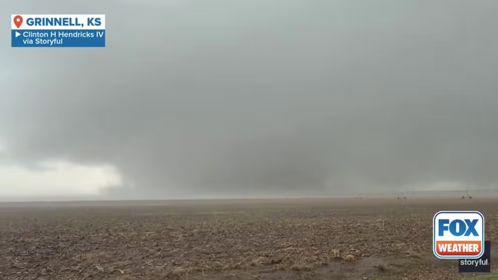
Watch: Large tornado rips through Grinnell, Kansas
A video shared from Grinnell, Kansas, shows a tornado as it bears down on the town on Sunday, May 18, 2025.
A video recorded on Sunday shows the tornado bearing down on the town. The tornado spins across the landscape, lofting clouds of dirt and debris into the air.
In Kiowa County, about 100 train cars derailed as a tornado tore across the area on Sunday night.
According to Union Pacific Railroad, the train crew had stopped the train about two miles west of the community of Haviland after learning of a Tornado Warning.
LONDON, KENTUCKY, TORNADO SURVIVORS PILED INTO BATHTUBS, EMERGED TO FIND EVERYTHING GONE
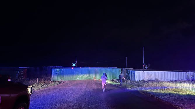
This image shows a train that was derailed during a Tornado Emergency in Greensburg, Kansas.
(@madelynn_wx/X / FOX Weather)
Officials said about 100 cars derailed, but no hazardous material was released.
"Union Pacific Railroad would like to thank the Kiowa County Sheriff's Department, which quickly responded to the scene and picked up our train crew," officials said in a statement to FOX Weather.
Numerous trees and power lines were also brought down in Kiowa County, and the sheriff’s office urged people to stay home and stay safe.
"It’s very dark out," the sheriff’s office said in a Facebook post. "We don’t want anyone getting into an accident."
The Kansas Department of Transportation said that it has reopened Interstate 70 between Colby and Hays after extreme weather moved through on Sunday evening and early Monday morning. However, eastbound and westbound traffic was reduced to one lane between mile markers 82 and 87 near Grinnell.
Exit 85 is also closed at Grinnell due to tornado damage and downed power lines in town.