Severe storms with damaging winds and heavy rain moving across South
Damage was reported in Jarrell, Texas, as severe thunderstorms rumbled from the Lone Star State into Louisiana Monday night and early Tuesday.
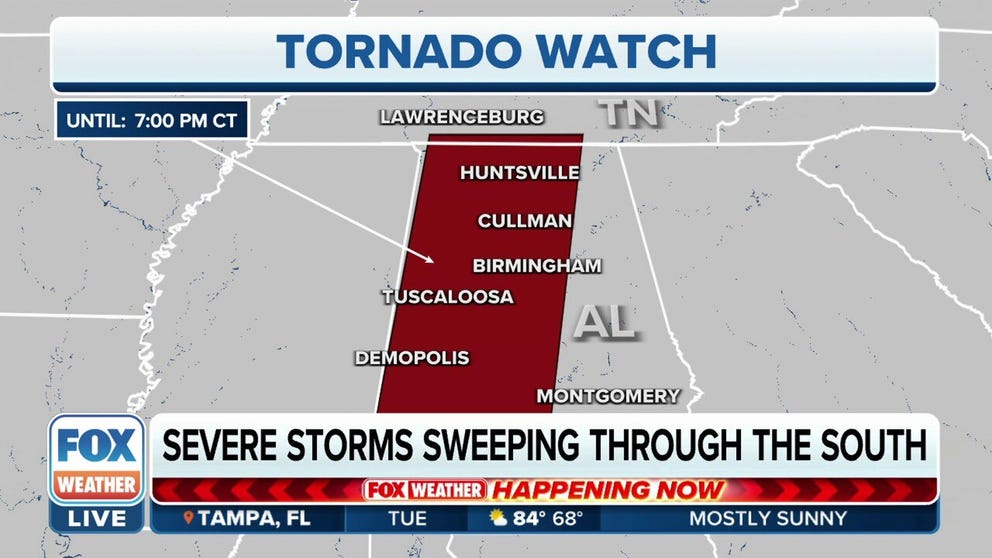
Tornado Watch issued for parts of Alabama, Tennessee
Tornado Watch has been issued for parts of Alabama and Tennessee until 7 pm CT.
Severe thunderstorms and flooding rainfall will threaten portions of the South on Tuesday as a cold front teams up with tropical moisture from former Hurricane Roslyn to create a ripe environment for storms.
While Roslyn's circulation dissipated over Mexico late Sunday, its limited moisture and upper-level energy are being pulled northward early this week by the advancing cold front and overspreading the southern and central U.S.
The Storm Prediction Center issued a Tornado Watch for parts of southern Tennessee and Alabama on Tuesday afternoon for the threat of damaging storms.
Severe storms Monday night and early Tuesday left some damage amid numerous Severe Thunderstorm Warnings and a few Tornado Warnings from Central and East Texas to western and southern Louisiana.
WATCH: LIGHTNING EXPLODES PECAN TREE AS SEVERE STORMS RIP THROUGH TEXAS
Law enforcement in Jarrell, Texas, reported an overturned tractor-trailer and cars in a ditch along Interstate 35 just outside the city Monday night. The Jarrell Fire Station also suffered roof damage and had doors and windows blown out, according to photos shared by the department. Video from the Jarrell area showed homes that had been damaged as well. It's not yet known whether a tornado struck the area or if this was all caused by damaging thunderstorm winds.

Suspected tornado leaves trail of damage along I-35 in Jarrell, Texas
A suspected tornado leaves a trail of damage along I-35 in Jarrell, Texas overnight.
The southern Plains were also soaked by heavy rain on Monday, but the heaviest rainfall Tuesday will shift into the mid-Mississippi and western Ohio valleys as the cold front slides east and is reinforced by a powerful storm system pushing out of the northern Plains.
You can see where showers and thunderstorms are ongoing right now in the three-hour radar loop below, which also shows any active Severe Thunderstorm or Tornado Warnings.

(FOX Weather)
Tuesday's severe storm threat
Strong to severe thunderstorms are expected Tuesday across parts of the mid-South and Deep South. This includes cities such as Memphis and Nashville in Tennessee, Jackson in Mississippi and Birmingham, Montgomery and Huntsville in Alabama.
Damaging wind gusts and a few tornadoes are the main threats from these storms.
"We could see wind gusts upwards of 60 mph, and that is going to throw up some debris," FOX Weather meteorologist Jane Minar said. "We could see the potential of downed trees, downed tree limbs, all leading to even some power outages."
TORNADO SAFETY: HOW TO IDENTIFY THE SAFEST PLACES INSIDE YOUR HOME

(FOX Weather)
Heavy rain threat in Midwest, South
Aside from the severe weather, the FOX Forecast Center is also monitoring the threat of heavy rainfall that could result in flash flooding early this week.
A widespread area of 1 to 3 inches of additional rain is expected across the lower and mid-Mississippi, Tennessee and western Ohio valleys through Tuesday night. Isolated amounts higher than 3 inches are possible in some locations, especially portions of Missouri and Illinois.
While the rain will be beneficial to many communities that are experiencing drought conditions, flash flooding could become a concern if too much rain falls in a short period of time.
On Wednesday, the threat of locally heavy rainfall will shift to the Great Lakes and parts of the Northeast, as occasional showers are expected from Chicago to the New York City tri-state area.

(FOX Weather)
Rain provides drought relief to parched central US
Nearly 95% of the region spanning the states of Texas, Oklahoma, Louisiana, Arkansas, Mississippi and Tennessee is currently experiencing drought conditions, with many areas seeing a rainfall deficit of more than 10 inches for the year.
The lack of rain has caused some tributaries of the Mississippi River to dry up, and a nearly 400-mile stretch of the waterway is at extremely low levels.
By Wednesday, some spots that desperately need the rainfall will have picked up several inches of precipitation.
SALTWATER CREEPING UP MISSISSIPPI RIVER AMID LOWEST LEVELS IN A DECADE

(FOX Weather)
The FOX Forecast Center said the rain would not be enough to restore river levels, but it will likely stop the waterline from dropping further.
After the early-week system heads eastward, the next significant chance of rain isn't expected to arrive until the end of the workweek.