Severe Thunderstorm Watch issued in Plains with storms also expected in Texas, Carolinas
A low-pressure system over the Southeast and a cold front pushing its way through central U.S. are helping to trigger the chance of storms through the end of the workweek and into the weekend. Saturday's threat eyes the hard-hit mid-South.
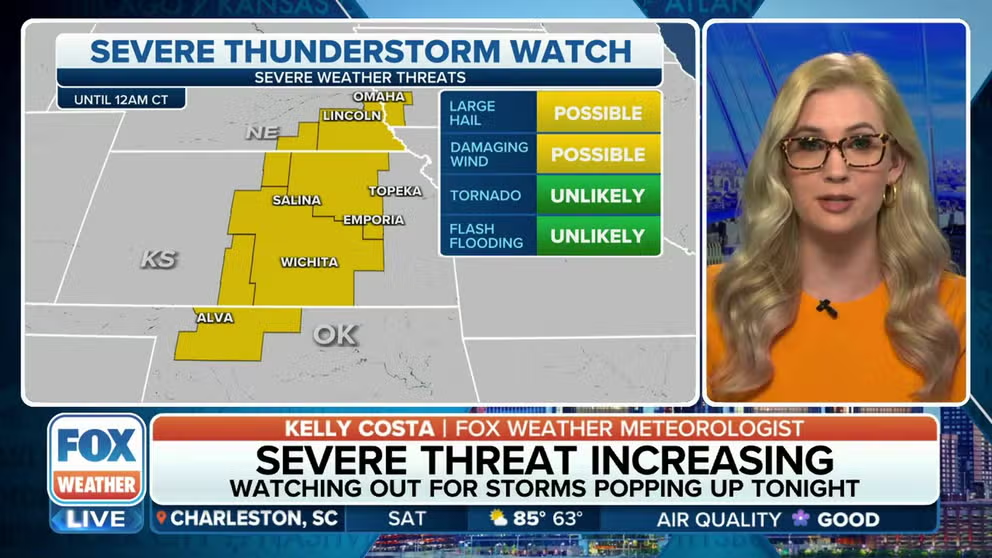
Severe thunderstorm watch issued for Plains
Large hail and damaging winds are the main threat as severe weather moves into the Plains.
The threat of severe weather is expected to linger over parts of the Southeast as attention turns to the Plains on Friday and the Mississippi Valley over the weekend for the chance of storms that could produce hail, damaging winds and even tornadoes.
Storms on Thursday impacted Georgia and Florida with heavy rain and Tornado Warnings. The FOX Forecast Center said the storms were courtesy of a low-pressure system that made its way into the Southeast from the Gulf of Mexico. A few trees and power lines were downed in the Peach State, but there were no reports of widespread flooding similar to what South Florida saw earlier in the week.
Storms on Wednesday dumped historic rain amounts in Broward County, with some areas that are estimated to have received more than 20 inches of precipitation in less than 24 hours. The flooding triggered the closure of the Fort Lauderdale-Hollywood International Airport and authorities declared a state of emergency to help with the response. The airport reopened Friday morning, but some flights were still facing significant delays.
VIDEO: SOUTH FLORIDA SEES MORE THAN A FOOT OF RAIN IN JUST HOURS, FLOODING FORT LAUDERDALE AIRPORT

'It was almost like being in a hurricane': Fort Lauderdale experiences extreme flooding
Streets and cars were underwater, buildings flooded, and travelers could not get in or out of Fort Lauderdale Hollywood International Airport and the rain is expected to continue on Thursday. FOX Weather's Brandy Campbell reports.
Where are the storms now?
Severe thunderstorms have developed in the Great Plains, with several Severe Thunderstorm Warnings being issued Friday evening. Some warnings have also been issued in the Carolinas.

(FOX Weather)
Friday's eastern storm zone
The Storm Prediction Center has highlighted a zone that runs from northern South Carolina through central North Carolina and into southern Virginia for the threat of damaging winds and hail on Friday.
The low-pressure system that has plagued Florida and the Gulf Coast all week is working its way through the South and will be responsible for helping kick off the scattered showers and thunderstorms.
The threat of storms that could produce heavy rain and possible damage includes cities such as Greenville, Columbia and Florence in South Carolina; Charlotte and Raleigh in North Carolina and South Hill in Virginia.

(FOX Weather)
Forecast models show many communities on the coast and along the Appalachian Mountains receiving an inch or two of rain through Saturday morning.
The FOX Forecast Center warned that slow-moving storms could drop locally higher amounts, and the rain will be monitored for the potential to create isolated pockets of flash flooding.
The National Weather Service always advises people to never attempt to drive on a flooded roadway, even though the weather might be sunny.
Friday's Great Plains storm zone
There is also the potential for severe storms Friday across parts of the Great Plains as a dryline stretching across Kansas down into Texas.
The FOX Forecast Center said substantial moisture from the Gulf of Mexico will return and lead to an environment capable of supercells east of the dryline, which could contain large hail, damaging winds and a threat for tornadoes.
"This is a classic spring setup," FOX Weather meteorologist Britta Merwin said. "We have that front that's moving in from the West. It's going to collide with this record-breaking heat that's been setting up for the whole week."
Storms are likely to peak during the evening hours Friday. By late Friday, an eastward advancing cold front will overtake the dryline and become the focal point for severe storms.

(FOX Weather)
Friday's storm zone in Texas
Southern parts of Texas also have a risk of severe storms on Friday evening. The risk area includes places like San Antonio and Victoria. Any severe storms that develop in this region have the potential to produce large hail and damaging winds. The complex of storms is expected to race east overnight and be along the middle Texas coast by Saturday morning.

(FOX Weather)
Weekend severe weather threat
Severe weather potential will continue into Saturday, with storms expected in parts of the Mississippi Valley and the mid-South. The highest threat zone includes Little Rock, Arkansas, which has already been hit hard by storms in recent weeks.
The FOX Forecast Center said these storms will be capable of tornadoes, golf ball-size hail and 60 mph wind gusts.
This system will reach the Ohio Valley and Mid-Atlantic on Sunday, with some severe thunderstorms expected.

(FOX Weather)