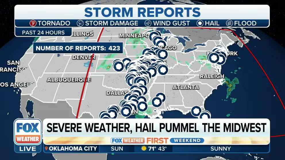
Tornadoes, large hail, 97-mph wind reported in America's heartland on Saturday
Large hail, strong winds and at least four tornadoes moved through parts of the Midwest Saturday. In Missouri, baseball-sized hail was seen, and the NWS confirmed an EF-1 tornado that moved through St. Louis County.

Baseball-sized hail slams Missouri
Severe thunderstorms tore across the central and southern U.S. over the weekend, dropping large hail and producing damaging wind along the way.
Severe thunderstorms tore across the central and southern U.S. on Saturday, dropping large hail and producing damaging wind along the way, and more severe weather was reported overnight into Sunday.
According to the National Weather Service, most fallen hail was between penny- and half-dollar-sized. However, there have been several reports of golf-ball-sized and baseball-sized hail. There has also been a report of grapefruit-sized hail near Arcola, Missouri.

Severe storms dump hail over Missouri
Baseball sized hail slammed into the Stockton State Park Marina in southwest Missouri.
ODD OBJECTS USED TO MEASURE HAILSTONE SIZE
Paige Graves told FOX Weather that her vehicle was heavily damaged when baseball-sized hail fell about 10 miles east of Lamar, Missouri.
"We've never had damage like this before here," Graves said.
There have also been reports of damaging wind with the storms in Missouri. A gust of 97 mph was recorded near the town of Vichy. There were also reports of damage to a mobile home, barn and trees in the area. Daniel Zimmerman also shared images with FOX Weather that showed damage to an airplane hangar at the Rolla National Airport in Vichy.
Severe weather, large hail causes damage in the Midwest
Severe weather tore across the central and southern U.S. on Saturday, producing large hail and damaging winds.
A Tornado Warning was issued for the St. Louis metro area as the line of storms marched across the Mississippi River. There were several reports of wind damage in the area, with a gust of 67 mph recorded at the St. Louis International Airport.
On Sunday, the National Weather Service confirmed at least four tornadoes touched down near St. Louis. Preliminary survey results found that the strongest, an EF-1 tornado, moved near I-44 in Fenton, Missouri, for 4.5 miles.
They said that
In a separate complex of storms tearing across the northern Gulf Coast, there have been a few reports of damaging wind gusts of more than 60 mph near New Orleans. There were several reports of fallen trees and power outages in that area, as well.
![A person holds a large hailstone that fell near Lamar, Missouri, on April 15, 2023.]() Image 1 of 5
Image 1 of 5A person holds a large hailstone that fell near Lamar, Missouri, on April 15, 2023. (Paige Graves/Facebook)
![A person holds a hailstone that fell southeast of Pittsburg, Kansas, April 15, 2023.]() Image 2 of 5
Image 2 of 5A person holds a hailstone that fell southeast of Pittsburg, Kansas, April 15, 2023. (The Mechaniacal/Twitter)
![A person holds a hail stone that fell in Barton County, Missouri, on April 15, 2023.]() Image 3 of 5
Image 3 of 5A person holds a hail stone that fell in Barton County, Missouri, on April 15, 2023. (Barton County Mo. Emergency Management)
![Damage to a hangar is seen at the Rolla Airport in Vichy, Missouri, on April 15, 2023.]() Image 4 of 5
Image 4 of 5Damage to a hangar is seen at the Rolla Airport in Vichy, Missouri, on April 15, 2023. (Daniel Zimmermann)
![Damage to a hangar is seen at the Rolla Airport in Vichy, Missouri, on April 15, 2023.]() Image 5 of 5
Image 5 of 5Damage to a hangar is seen at the Rolla Airport in Vichy, Missouri, on April 15, 2023. (Daniel Zimmermann)


Where are the storms now?
Showers and storms developed across many parts of the eastern U.S. However, the severe weather was concentrated in Missouri and Arkansas. Dangerous storms also developed along the southern end of the cold front that caused all the nasty weather, spreading the activity into Louisiana and Texas. Severe storms continued moving east through the overnight hours.
Due to the invasion of much cooler air, on the northern side of the low, snow is being produced. The frozen precipitation is expected to make its way through the Upper Midwest and Great Lakes over the next 72 hours.
VIDEO: SOUTH FLORIDA SEES MORE THAN A FOOT OF RAIN IN JUST HOURS, FLOODING FORT LAUDERDALE AIRPORT

(FOX Weather)
Sunday’s threat zone
The cold front that triggered Saturday's severe weather is expected to continue its eastward trek Sunday and produce showers and thunderstorms from the Great Lakes to the Gulf Coast.
The FOX Forecast Center expects if a storm turns strong to severe over the Ohio and Tennessee valleys, the greatest threats will be from hail or gusty winds.
Farther south in Georgia and South Carolina, afternoon heating may lead to a more organized line of storms.
Forecast models show many communities picking up less than an inch of rain, but where storms train over the same region, isolated higher amounts are possible, especially across the South.
