Powerful Kona Low to lash Hawaii with torrential rain, fierce winds, blizzard conditions, Flood Watches issued
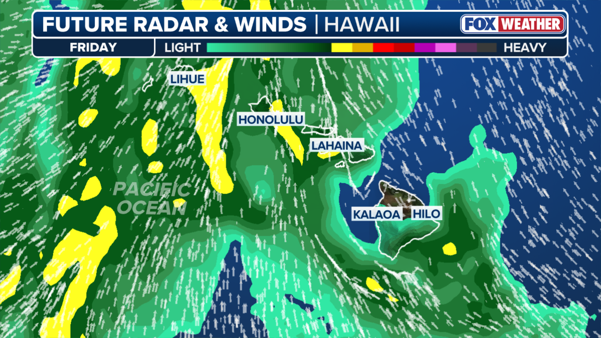
A widespread flash flooding threat is possible across most of the islands, with 5–8 inches of rain expected and some areas potentially receiving over a foot by Saturday.

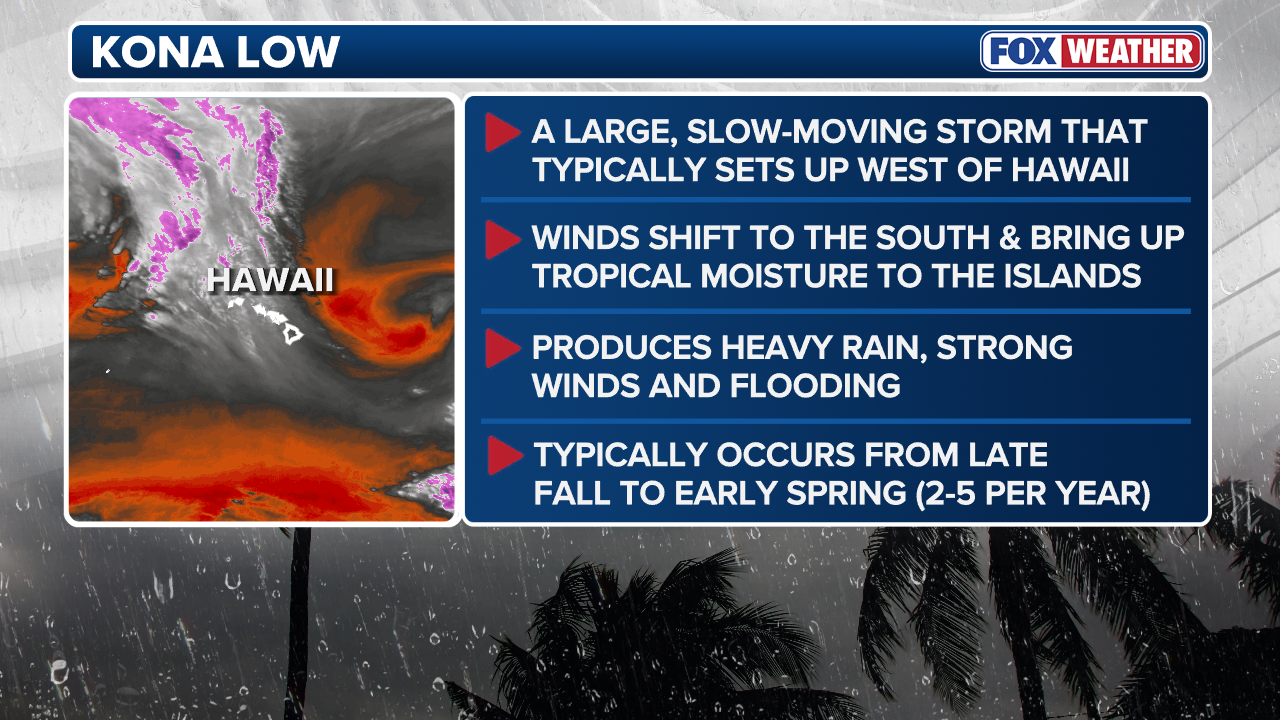
Kona Low delivering heavy, flooding rains to Hawaii
Hawaii is getting drenched by a Kona Low, which has dropped more than 8 inches of rain on Maui. Flood Watches are in effect through Saturday morning Hawaii time.
A powerful Kona Low is unleashing heavy rain, damaging winds and even blizzard conditions across Hawaii’s mountain peaks through the upcoming weekend.
Heavy rain is continuing to overtake the Hawaiian Islands with ongoing heavy rain and storms. With a combination of strong upper-level forcing, deep tropical moisture, and persistent southerly flow, the environment is extremely favorable for periods of heavy rain and thunderstorms.
Some locations have already seen over 8" of rain on Maui, which has already led to some flash flooding across parts of the island.
WATCH: HAWAII'S KĪLAUEA VOLCANO ERUPTS, SENDING RAGING LAVA FOUNTAIN 1,500 FEET INTO THE AIR
On Thursday, a Flash Flood Warning was issued for Honolulu as rainfall rates reached 2-3" per hour.
Flood Watches are in effect, with strong winds increasing the risk of power outages and blizzard conditions.
The strong Kona Low is delivering numerous hazards across the islands this afternoon.

(FOX Weather)
Heavy rain moved into Kauai and Oahu Tuesday night before spreading across the western end of the state into Wednesday.
A widespread flash flooding threat with 5-8 inches of rain is possible across most of the islands, with some areas potentially seeing over a foot of rain through Saturday.
LIVE UPDATES: DANGEROUS STORM SYSTEM THREATENS MILLIONS WITH STRONG TORNADOES AND GIANT HAIL
(FOX Weather)
Hawaii Volcanoes National Park issued temporary closures within the park due to the threat of severe storms.
The national park said Mauna Loa Summit is closed, as well as several trails, camping sites and a lookout point.
Visitors are advised to use extreme caution on roadways, trails and crosswalks due to reduced visibility, watch out for falling trees and branches and be prepared for heavy rain and wind.
The national park said it will re-evaluate conditions on Monday, and reopen everything if it's safe.
PHOTOS: LANDSLIDE BLOCKS HIGHWAY AS SEVERE STORM DROPS MONUMENTAL AMOUNT OF RAIN IN HAWAII
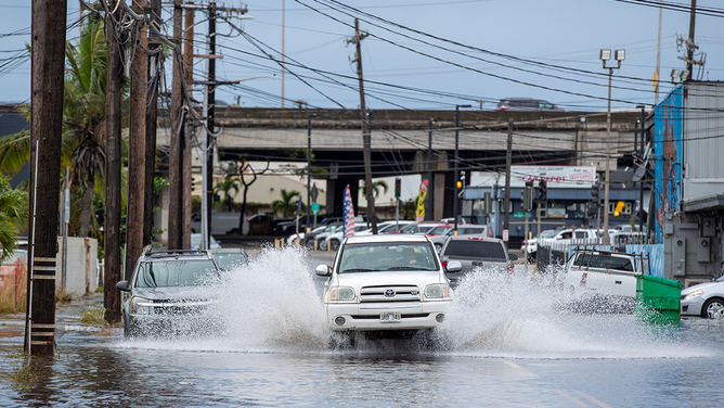
A pickup truck plows through a flooded street in Honolulu, Hawaii on December 7, 2021, the morning after powerful winter tropical storm known as a Kona Low hit the Hawaii islands with heavy rain and high winds causing wide spread flooding and power outages across the state. - Hawaii's Governor David Ige issued a state of emergency for all of the states islandson December 6. The National Weather Service reports the threat of catastrophic flooding as the storm system slowly moves from east to west.
(EUGENE TANNER/AFP via Getty Images / Getty Images)
A widespread flash flooding threat with 5–8 inches of rain is possible across most of the islands, with some areas potentially seeing over a foot of rain through Saturday, prompting Flood Watches across Niihau and Kauai through Saturday morning.
(FOX Weather)
As the atmospheric moisture levels are to remain relatively high, it will lead to storms capable of producing very heavy rainfall rates, heightening the flood risk.
The FOX Forecast Center also highlights the potential for landslides from this event.
In addition to the rain threat, strengthening south to southwest winds will develop as the pressure gradient tightens between the developing Kona Low and high pressure to the east.

FILE: Snow coated the roads on Mauna Kea, a dormant volcano on Hawaii's Big Island Monday, as a storm known as a Kona Low dumped inches of snow across higher elevations.
(Derek Petrowski via Storyful / FOX Weather)
The setup could lead to damaging winds and localized downslope winds capable of downing trees and power lines.
With all that said, the summits of the Big Island will likely see periods of snow with significant accumulations through the weekend and, accompanied by the gusty winds, blizzard conditions remain possible at the summits into Friday and Saturday.