Sprawling severe weather threat charges east, targeting more than 95 million from Texas to New York
Two main zones are in the bull's-eye of Wednesday's tornado threat: the Deep South from East Texas through southern Alabama, and the Ohio Valley from Central Ohio to western Pennsylvania, West Virginia and western Maryland.

Severe weather threat charges east, targeting more than 95 million from Texas to New York
The same cold front responsible for Tuesday’s tornadoes and storms will push southeast through the Mississippi Valley and eventually into the Ohio and Tennessee valleys during the day Wednesday. Two main zones are in the bull's-eye of Wednesday's tornado threat: the Deep South from East Texas through southern Alabama, and the Ohio Valley from Central Ohio to western Pennsylvania, West Virginia and western Maryland.
The final day of the sprawling 1,000-mile, multi-day severe weather threat that slammed the Heartland Tuesday targeted more than 95 million people as it charged into the Eastern Seaboard Wednesday.
The same cold front responsible for Tuesday's storms, including the damaging tornadoes that slammed parts of Illinois and Indiana, pushed through the Mississippi Valley and into the Ohio and Tennessee valleys on Wednesday, triggering thunderstorm development.
![LAKE VILLAGE, INDIANA - MARCH 10: First responders survey a destroyed Family Dollar store where two employees were trapped and later rescued uninjured after a tornado struck on March 10, 2026 in Lake Village, Indiana. The National Weather Service had issued an urgent warning about a large tornado moving through the area, calling it a "life-threatening situation."]() Image 1 of 3
Image 1 of 3LAKE VILLAGE, INDIANA - MARCH 10: First responders survey a destroyed Family Dollar store where two employees were trapped and later rescued uninjured after a tornado struck on March 10, 2026 in Lake Village, Indiana. The National Weather Service had issued an urgent warning about a large tornado moving through the area, calling it a "life-threatening situation." ((Photo by Michael Hickey/Getty Images))
![LAKE VILLAGE, INDIANA - MARCH 10: An employee emerges after being rescued from a Family Dollar store destroyed by a tornado on March 10, 2026 in Lake Village, Indiana. The National Weather Service had issued an urgent warning about a large tornado moving through the area, calling it a "life-threatening situation."]() Image 2 of 3
Image 2 of 3LAKE VILLAGE, INDIANA - MARCH 10: An employee emerges after being rescued from a Family Dollar store destroyed by a tornado on March 10, 2026 in Lake Village, Indiana. The National Weather Service had issued an urgent warning about a large tornado moving through the area, calling it a "life-threatening situation." ((Photo by Michael Hickey/Getty Images))
![BLOOMINGTON, INDIANA - FEBRUARY 19: Lightning streaks across the sky over west Bloomington as seen from Rosehill Cemetery on February 19, 2026, in Bloomington, Indiana. At least one tornado later touched down, damaging a bank, the animal shelter, and multiple homes and other structures.]() Image 3 of 3
Image 3 of 3BLOOMINGTON, INDIANA - FEBRUARY 19: Lightning streaks across the sky over west Bloomington as seen from Rosehill Cemetery on February 19, 2026, in Bloomington, Indiana. At least one tornado later touched down, damaging a bank, the animal shelter, and multiple homes and other structures. ((Photo by Jeremy Hogan/Getty Images))


According to the FOX Forecast Center, this cold front will act as the main trigger for new thunderstorm development, which is different from how the severe storms formed on Tuesday.
"Areas that saw significant severe storms Friday and Saturday will be hit again as this progresses eastward," the FOX Forecast Center said.
Tornado Watches were issued for Ohio, West Virginia and Kentucky through Wednesday afternoon, as well as across parts of East Texas and Louisiana in the southern component of the severe weather threat.

(FOX Weather)
All modes of severe weather were possible on Wednesday, including damaging wind gusts, hail and tornadoes.
A large Level 2 out of 5 risk of severe thunderstorms stretched from East Texas through the Lower Mississippi, Tennessee and Ohio valleys.
'MELISSA' OFFICIALLY RETIRED FROM FUTURE HURRICANE NAMES FOLLOWING DEADLY DESTRUCTION IN JAMAICA
This includes the Houston, New Orleans, Nashville, Pittsburgh and Washington, D.C. metro areas.
A Level 1 out of 5 severe storm threat also included parts of southern and central New Jersey and parts of New York's Southern Tier.

(FOX Weather)
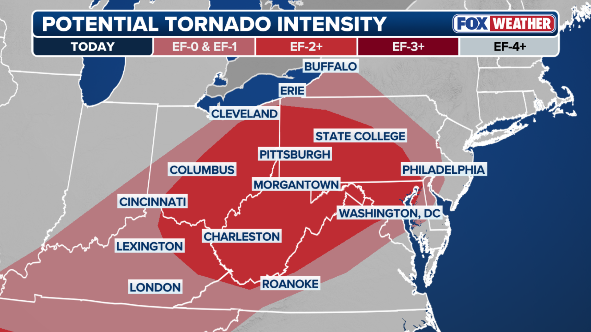
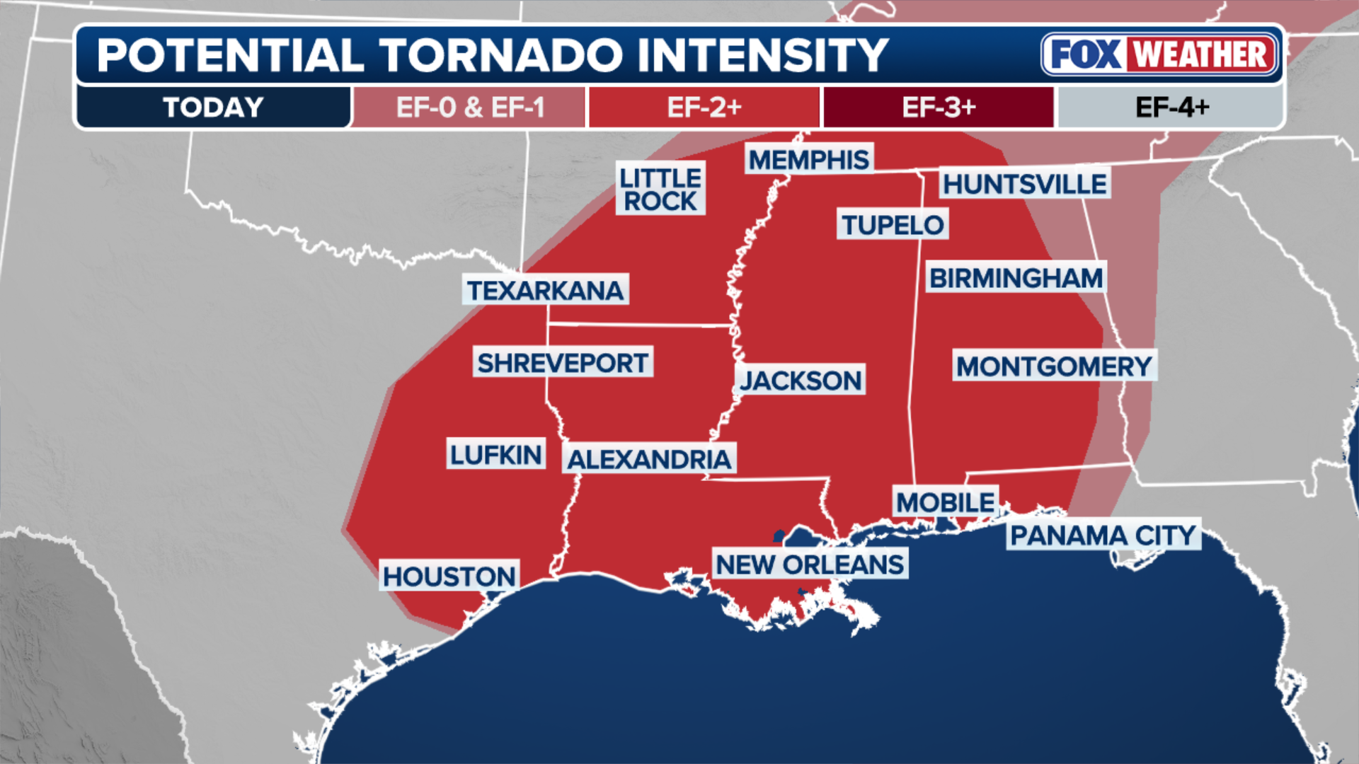
Two main regions are in the bull's-eye of Wednesday's tornado threat: the Deep South from East Texas through southern Alabama, and the Ohio Valley from Central Ohio to western Pennsylvania, West Virginia and western Maryland.
NOAA'S STORM PREDICTION CENTER DEBUTS REVAMP TO SEVERE WEATHER OUTLOOKS THIS SEASON
Strong EF-2 tornadoes are possible in these areas; EF-1 tornadoes are possible in Washington, D.C. and just west of Philadelphia.
The FOX Forecast Center warned people in and around Philadelphia, Baltimore, and Washington, D.C. to prepare for the most significant weather that arrived Wednesday evening.
(FOX Weather)
The southern threat zone for strong tornadoes includes Houston, New Orleans, and Mobile, Montgomery and Birmingham, Alabama, as well as Memphis, Tennessee.
The FOX Forecast Center said these storms also brought torrential downpours to this region.
DEADLY TORNADO DEVASTATES UNION CITY, MICHIGAN, CARVING A PATH OF HEARTBREAKING DAMAGE IN COMMUNITY
(FOX Weather)
This is the final act of a multi-day severe weather threat which is expected to continue into the overnight hours Thursday before finally winding down.