NOAA's Storm Prediction Center debuts revamp to severe weather outlooks this season
Conditional Intensity Groups will be used to communicate the expected intensity of severe storms and the levels of hazards that are being projected.

NOAA Storm Prediction Center refines severe weather outlook
The SPC has introduced changes to their severe weather outlook, introducing new intensity levels to highlight specific threats for storms. Bill Bunting, Storm Prediction Center deputy director, joins FOX Weather to talk about how these changes will allow forecasters to convey how strong the impacts of a severe day might be.
As the severe weather season gets underway, NOAA's Storm Prediction Center is adding additional types of severe weather outlooks to their forecasts this year — designed to help people better prepare for expected tornadoes, wind gusts and hail.
Debuted on March 3, 2026, the revamped outlook marks a major milestone in how the risk of dangerous storms is communicated to the public before they happen.
The Storm Prediction Center (SPC) is a part of the National Weather Service (NWS) operating under the National Oceanic and Atmospheric Organization (NOAA) and provides forecasts for severe thunderstorms and tornadoes in the U.S.
Currently, the SPC uses a five-level scale to communicate the severe weather threat for a particular area: "Marginal," "Slight," "Enhanced," "Moderate" and "High."
THE SPC 5-POINT SEVERE THUNDERSTORM RISK CATEGORY SCALE EXPLAINED
While those categories will remain, the SPC is adding new "Conditional Intensity Groups" to highlight exactly how intense hazards like tornadoes, wind and hail will be.
Out with the old
Currently, the SPC draws a "hatched area" on outlooks to describe where particularly nasty hazards should be expected based on the environmental conditions and types of storms that are forecast.
In the image below, the hatched area is indicated by a black shape filled with small black lines, which indicate a significant threat of a particular type of severe weather.
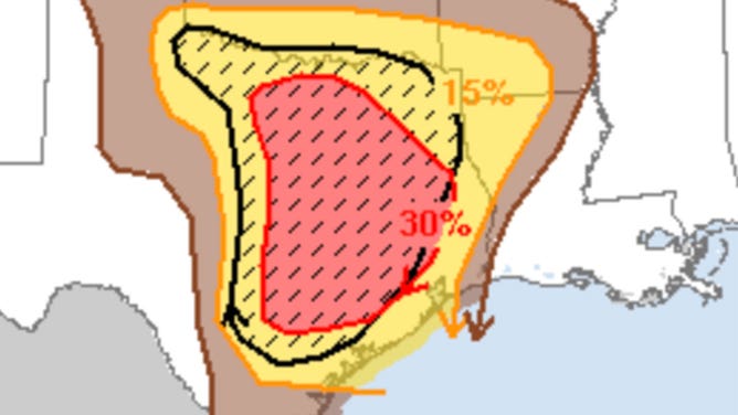
A hatched area is seen on a hail outlook map issued by the Storm Prediction Center on March 21, 2022.
(NOAA/SPC)
Inside the hatched area signifies the potential for EF-2+ tornadoes, 75+ mph winds and hail greater than 2".
Whether it meant extreme straight-lined winds, destructive hail or catastrophic tornadoes, the old system hatching was the same whether the SPC was expecting a strong EF-2 or a dangerous EF-5 tornado.
The new CIG levels aim to better communicate the storm intensity the SPC expects in a certain area for a particular type of severe weather.
![]() Image 1 of 3
Image 1 of 3OLD EXAMPLE: Prior to the introduction of the Storm Prediction Center's (SPC) Conditional Intensity Groups, tornado maps would signify one intensity level, with a specific highlighted area where stronger tornadoes are possible. ( )
![]() Image 2 of 3
Image 2 of 3OLD EXAMPLE: Prior to the introduction of the Storm Prediction Center's (SPC) Conditional Intensity Groups, maps would signify one intensity level and did not highlight the type of storm, with a specific highlighted area where stronger winds and thunderstorms are possible. ( )
![]() Image 3 of 3
Image 3 of 3OLD EXAMPLE: Prior to the introduction of the Storm Prediction Center's (SPC) Conditional Intensity Groups, maps would signify one intensity level, with a specific highlighted area where large hail is possible. ( )


In with the new
Going forward, in accordance with the SPC's Convective Outlook maps, CIG intensity groups will look like this in future FOX Weather graphics.
TORNADO INTENSITY
- No level: Mostly EF-0 or EF-1
- Level 1: Up to EF-2
- Level 2: Up to EF-3
- Level 3: Up to EF-4

NEW EXAMPLE: With the introduction of the Storm Prediction Center's (SPC) Conditional Intensity Groups, new tornado graphics maps could feature three intensity levels in specific areas if applicable. An EF-4+ is reserved for rare, historic-level outbreaks.
(FOX Weather)
HOW ARE TORNADOES RATED? THE ENHANCED FUJITA (EF) SCALE EXPLAINED
At each intensity, there will be a small chance for a stronger tornado than the max rating shown. For that reason, FOX Weather graphics will feature a "+" sign.
WIND INTENSITY
- No level: Mostly less than 75 mph winds.
- Level 1: Max gusts greater than 75 mph.
- Level 2: Bow echo or derecho is possible with max gusts greater than 85 mph.
- Level 3: High-end derecho ongoing. Max gusts likely greater than 95 mph.

NEW EXAMPLE: With the introduction of the Storm Prediction Center's (SPC) Conditional Intensity Groups, new wind graphics maps could feature three intensity levels in specific areas if applicable.
(FOX Weather)
HAIL SIZE
- No level: Mostly less than 2".
- Level 1: Larger than 2" (Size comparison: hen egg)
- Level 2: Larger than 3.5" (Size comparison: softball)

NEW EXAMPLE: With the introduction of the Storm Prediction Center's (SPC) Conditional Intensity Groups, new hail maps could feature two intensity levels in specific areas if applicable, better highlighting the destructive hail potential.
(FOX Weather)
Simply put
For over a decade, the "Marginal to High" risk scale has been the gold standard for severe weather preparedness, but the introduction of CIG marks the most significant evolution in SPC history since 2014.
If you’ve looked at the SPC maps issued today and noticed new hatching patterns or extra numbers, don't worry. The system hasn't become more dangerous, it’s just become much more precise.
The biggest takeaway is that the 1-to-5 Categorical Risk scale is not changing. You will still see Level 1, 2, 3, 4 and 5 risks from FOX Weather. These still represent the probability and coverage of severe weather.
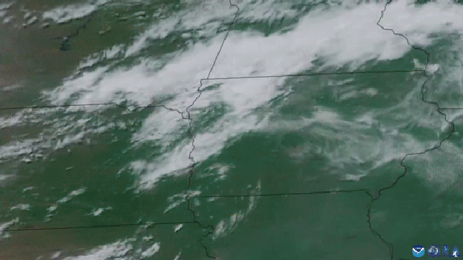
FILE: This satellite image captured by NOAA's GOES 16 satellite captured images of the deadly and powerful derecho as it swept across the Midwest on Monday, July 15, 2024.
(NOAA)
"It's a smarter way to be prepared and stay safe," SPC Meteorologist Evan Bentley said in a post on X.
Simply put, the introduction of Conditional Intensity Groups further communicate the specific threat of severe weather.
Level 1 shows that significant severe weather is possible.
Level 2 shows a dangerous environment with the potential for intense (EF-3+) tornadoes or extremely large hail.
Level 3 shows rare, historic outbreak-level intensity with violent (EF-4+) tornadoes or derechos.