Tornado threat increases for millions across the South as severe storms continue
This stormy weather pattern across the middle of the country comes right on cue, as March marks the typical beginning of the spring severe weather season.

Tornado threat increases for millions across Texas and Oklahoma
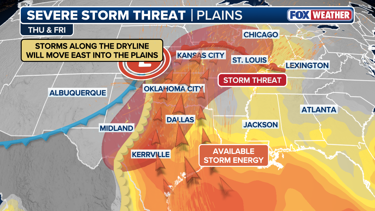
Forecasters have upgraded Thursday's severe weather outlook to a Level 3 out of 5 severe storm threat for a narrow area in Western Oklahoma and portions of the Texas Panhandle where storms could produce EF-2 or stronger tornadoes. Meanwhile, the Storm Prediction Center continues to highlight Friday as having the greatest risk of large hail, damaging wind gusts and tornadoes.
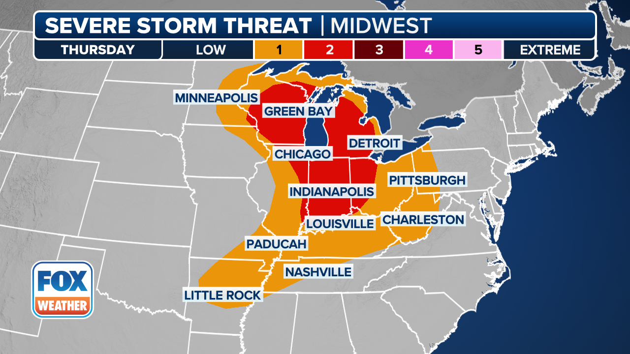
Millions across Texas, the Plains and Midwest are in the path of a multi-day severe weather threat as rounds of thunderstorms develop over the central U.S.
NOAA's Storm Prediction Center (SPC) has highlighted Friday as having the greatest risk of large hail, damaging wind gusts and tornadoes.
PARADE OF STORMS TO EASE MISSISSIPPI VALLEY DROUGHT AS FLASH FLOODING THREAT POTENTIAL RISES
This stormy weather pattern across the middle of the country comes right on cue, as March marks the typical beginning of the spring severe weather season.
(FOX Weather)
The multi-day severe storm threat will continue through the end of the week. Storm chances later in the week will not be fueled by a sprawling cold front, but by a dryline that is forecasted to develop across west Texas and Oklahoma.

Hail fell in Barnhart, Missouri late Wednesday.
(Keith Vinyard / FOX Weather)
A dryline is a boundary between dry air moving out of the Rockies and extremely humid air pouring north from the Gulf.
(FOX Weather)
WHAT IS A DRYLINE AND WHY IS ITS LOCATION IMPORTANT IN SEVERE WEATHER FORECASTING?
A level 3 out of 5 severe storm threat was issued for a narrow area in western Oklahoma and portions of northern Texas on Thursday.
Plenty of instability, moisture and wind shear paved the way for large, damaging hail. A Tornado Watch was issued for the stronger storms, and a few Tornado Warnings were issued in Oklahoma and Texas.

(FOX Weather)
The storm started in west Texas and gradually moved through parts of central Kansas and Oklahoma into the evening and overnight period.
According to the FOX Forecast Center, forecasters are warning of a significant tornado threat, with the potential for storms to reach EF-2 strength or even stronger. Using the NWS Storm Prediction Center's (SPC) new Conditional Intensity (CIG) tools, the SPC is able to differentiate these high-intensity threats, even when storm coverage remains scattered.

Heavy rain and lighting come down in Texas
Severe weather is continuing to move through the south after already bringing heavy rain, thunder and lightning to areas like Crowley, Texas on Wednesday.
Friday
The severe storm threat continues as a level 3 out of 5 for Friday, as the dryline swings further east. However, winds will heighten the risk.
Lower-level winds, approximately 5,000 feet above the surface, are expected to strengthen both to the north near Kansas City and to the south toward Oklahoma City and Dallas. This will give more support for more intense storms.
These features will significantly increase the potential for a severe storm outbreak. A more favorable area of wind shear will develop, creating an environment for supercells and an increased tornado threat.

Lightning blasts Texas neighborhood
Lightning strikes were spotted across parts of the South, such as Tow, Texas, as severe weather moved through the area on Wednesday, with more severe weather lasting into next week.
WHAT IS A SUPERCELL THUNDERSTORM?
During the early evening hours, strong tornadoes are possible from Kansas City to Wichita to Oklahoma CIty as the best atmospheric conditions will be in place.
"Any storm that develops ahead of the main line of storms will have the best chance to produce a tornado," the FOX Forecast Center said.

(FOX Weather)
Outside the threat of tornadoes, all other severe hazards are likely to emerge by midday Friday, continuing through the overnight hours and into early Saturday morning.
Very large to monster-sized hail, greater than 3 inches in diameter, is a major concern on the northern side of the storm system.
According to the FOX Forecast Center, the bottom line is a very active period of severe weather is beginning to take shape and will last into Saturday morning, impacting much of the Central and Southern Plains into the Mississippi Valley.