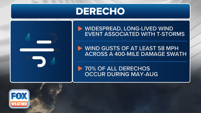
What is a derecho?
In order for a cluster of thunderstorms to be classified as a derecho, the swath of straight-line winds must be more than 250 miles long.

What is a derecho?
Forecasters are saying a derecho is likely to form on Monday, July 28, across portions of the Northern Plains and Upper Midwest, but what does that mean? FOX Weather Meteorologist Craig Herrera breaks it all down.
A derecho is a cluster of thunderstorms that produces destructive wind gusts for hundreds of miles and has the potential to impact millions of people.
For meteorologists to classify a windstorm as a derecho – from the Spanish word for "straight" – the swath of straight-line wind damage it causes must contain multiple wind gusts of at least 75 mph that are associated with the same cluster of thunderstorms, known in meteorological terms as a mesoscale convective system, according to the American Meteorological Society.
The parent MCS must be at least 60 miles long and last for at least 3 hours. All wind reports in the swath must occur in a progressive sequence in one direction.
The swath itself must be more than 250 miles long to be considered a derecho.
This graphic shows the definition of a derecho.
(FOX Weather)
Derechos can occur at any time of the year but are more common when a clash of air masses happens during the spring and summer.
DOWNLOAD THE FREE FOX WEATHER APP
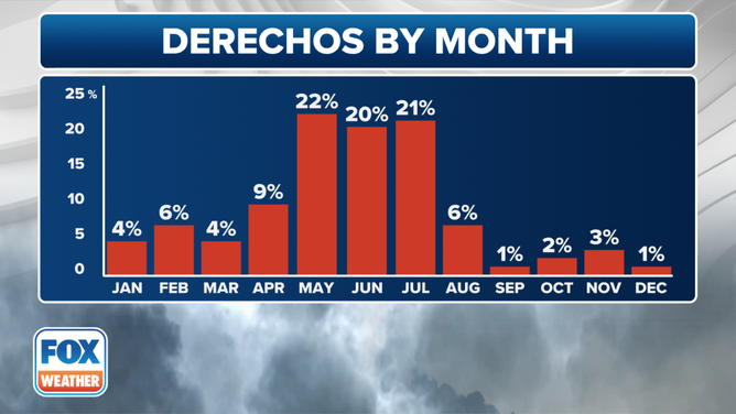
This graphic shows derecho occurrence by month
(FOX Weather)
The damaging-wind events vary in size, but it is not uncommon for them to wind gusts exceeding 100 mph, the equivalent of a Category 2 hurricane, and produce tornado-like destruction for several hundred miles.
THIS IS AMERICA'S MOST ACTIVE TIME FOR DAMAGING THUNDERSTORM WINDS, INCLUDING DERECHOS
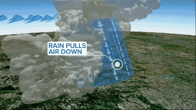
A derecho is a cluster of thunderstorms with destructive winds.
(FOX Weather)
One of the most significant derecho events in U.S. history occurred in the Midwest during the summer of 2020.
During the event, winds gusted up to 140 mph, causing more than $7.5 billion in damage.
If you are in the path of a high-wind event such as a derecho, it is advised that you get indoors and move away from windows and doors.
HOW PUBLIC SAFETY OFFICIALS NOTIFY YOU DURING SEVERE WEATHER EMERGENCIES
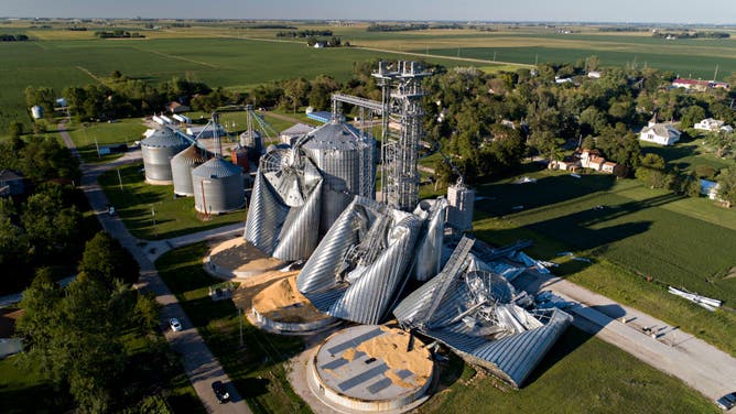
In this aerial image from a drone, damaged grain bins are shown at the Heartland Co-Op grain elevator on Aug. 11, 2020, in Luther, Iowa. Iowa Gov. Kim Reynolds said early estimates indicated 10 million acres, nearly one-third of the states land used for crops, were damaged when a powerful storm battered the region a day earlier.
(Daniel Acker / Getty Images)