Live updates: Violent storms slam millions, unleashing intense tornadoes, giant hail in Midwest
Live updates: Violent storms slam millions, unleashing intense tornadoes, giant hail in Midwest
Download the AppLIVE Severe Weather HQ coverage continues
View postCoverage for this event has ended.
Our minute-by-minute coverage of the destructive tornado outbreak that tore through Illinois and Indiana continues today as the storm threat shifts east.
FOX Weather Meteorologist Ari Sarsalari breaks down the dangerous severe storm that ripped through the Kankakee, Illinois area, spawning numerous tornadoes that caused significant damage in impacted areas and triggered the first Tornado Emergency of the year.
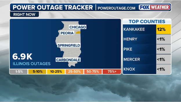
Thousands are without power in the Midwest after a severe weather outbreak spawned numerous tornadoes in Illinois and Indiana.
A large swath of communities in northern Illinois and northwest Indiana is experiencing significant power outages tonight as a line of severe thunderstorms continues its eastward march.
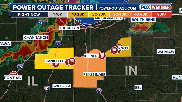
Power Outage map using data from poweroutage.com
According to poweroutage.com, tens of thousands of customers are without electricity from Kankakee and surrounding areas into eastern Indiana, illustrating the broad impact of the ongoing storm system.
The hardest-hit zones include areas near Kankakee, Rensselaer and Knox, where outage counts have climbed after dangerous severe storms slammed the region.
This widespread outages come as storms packed with damaging winds, lightning and heavy rain sweep across the region.
Reports have linked many of these outages directly to storm-related impacts, including fallen limbs and toppled utility poles.
Residents are urged to stay weather-aware, prepare for possible extended outages and take normal storm safety precautions — especially while powerful thunderstorms remain in the vicinity.
Officials in northwest Indiana say Lake Village took a direct hit from a damaging tornado that destroyed multiple homes as severe storms swept across the region.
In a Facebook update, Newton County Sheriff Shannon Cothran and Lake Township Fire Chief Rob Churchill confirmed that the tornado caused significant destruction in the community. Several homes were destroyed when the storm moved through, leaving debris scattered across neighborhoods.
"Multiple homes (have been) destroyed, Lake Village took a direct hit," Chief Churchill said.
First responders remain on scene, working to clear debris and assist residents who have been displaced by the storm. Emergency crews are assessing damage and helping families begin the recovery process.
Authorities also announced that a shelter has been opened at a local middle school to provide temporary housing and support for those impacted by the tornado. Residents are encouraged to seek assistance there if their homes were damaged or destroyed.
Kankakee County officials — including Sheriff Mike Downey, County Board Chairman Matthew Alexander-Hildebrand and Mayor Chris Curtis — have activated the Emergency Operations Center and filed an emergency disaster declaration with the State of Illinois. Meanwhile, emergency crews remain in the field conducting damage assessments and continuing search efforts.
The Kankakee County Sheriff's Office announced that there are no injuries or deaths as of 10:30 p.m. EST.
A storm chaser is reporting a 5.2-inch diameter hailstone just southwest of Kankakee — a size that would set a new Illinois state record if confirmed.
In what is the largest hail report of the night, the massive hailstone fell just outside the same city that was struck earlier by a dangerous tornado.
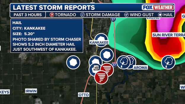
Latest Storm Reports from Illinois
Significant damage has already been reported in the area, and the potential state-record hail highlights the extreme intensity of the storms that tore through Kankakee and surrounding communities.
A dangerous line of severe thunderstorms is sweeping across northern Illinois Tuesday night, placing Chicago squarely in the bullseye as the storms march east.
Live radar imagery shows a well-defined line of intense storms stretching from Joliet through downtown Chicago and extending north toward Wheeling.
The line is packed with heavy rain, frequent lightning and embedded pockets of extreme reflectivity — a sign of torrential downpours and potentially damaging wind gusts.
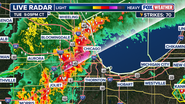
FOX Weather Live Radar
Forecasters warn that storms of this structure can produce damaging straight-line winds capable of downing trees and power lines, along with isolated spin-up tornadoes.
Travel conditions across the Chicago metro are likely to be hazardous as blinding rain and gusty winds move through during the evening hours.
Residents are urged to remain indoors, secure loose outdoor items and stay weather-aware as the line continues its eastward push.
The Newton County Sheriff’s Office says several homes in Lake Village, Indiana, were struck by a damaging tornado that swept through the town along the eastern Illinois-Indiana state border.
In a video posted to Facebook, an officer said the community has sustained “a lot of damage,” describing significant impacts to homes and property as the storm moved through.
First responders are on the ground in Lake Village, working to assess the destruction, check for injuries and secure damaged areas in the immediate aftermath of the tornado. Emergency crews are urging residents to avoid affected neighborhoods to allow responders to move safely through debris-strewn streets.
The tornado is part of a broader and dangerous severe weather outbreak unfolding across the Midwest.
Forecasters have warned that the threat is far from over. Communities across the region are being urged to remain weather-aware and prepared to take shelter at a moment’s notice as this high-impact severe weather event continues.
A Tornado Emergency has been issued for Knox, Indiana as a confirmed "deadly" tornado rips through the area. The emergency is in place until 9 p.m. CDT for cast central Starke County.
The confirmed large and destructive tornado was located over Knox, moving east at 30 mph, the National Weather Service Warning said.
"Mobile homes will be destroyed. Considerable damage to homes, businesses, and vehicles is likely and complete destruction is possible," the warning said.
The rare and life-threatening Tornado Emergency has declared in Knox is the first issued anywhere in the U.S. in 2026 as a volatile severe weather outbreak continues to hammer the Midwest.
A Tornado Emergency is the National Weather Service’s most dire tornado alert, reserved for confirmed, large and destructive tornadoes that pose an imminent threat to life and property — often in or near populated areas.
The designation signals catastrophic potential damage and is used sparingly, underscoring the seriousness of the situation unfolding near Knox.
Kankakee County officials are continuing to assess damage after powerful storms — including at least one confirmed tornado — swept through the area late Thursday.
According to the Kankakee County Sheriff’s Office, a tornado touched down south of Kankakee near the Kankakee Fairgrounds before tracking northeast.
The storm then crossed the Kankakee River into Aroma Park, where extensive damage is being reported.
Deputies and emergency crews from agencies across the county remain in the field checking for injuries and surveying the destruction.
As of the latest update, no injuries have been reported. Authorities are urging residents to limit travel as much as possible due to downed trees, debris-covered roadways and power lines brought down by the storm.
The county’s 911 dispatch center, KanComm, is also being inundated with calls. Officials are asking the public not to call 911 for non-emergency questions in order to keep lines open for those facing life-threatening situations.
Residents are encouraged to monitor the Kankakee County Sheriff’s Office social media channels for the latest updates as crews continue their response and recovery efforts.

Top hail reports
Sprawling and volatile severe storms are slamming parts of the Plains and Midwest, unleashing destructive storms that have produced reports of massive, grapefruit-sized hail in both Texas and Illinois.
Drone footage captures the immediate aftermath of a destructive tornado that ripped through Kankakee, Illinois, demolishing several structures on its path through the northeastern Illinois city.
The footage reveals the staggering scope of destruction left behind after a powerful tornado that tore through Kankakee before crossing into Indiana.
From above, entire rooftops are peeled back or torn away, walls lie collapsed and debris is strewn in every direction — an area left flattened in the path of a dangerous tornado.
After a damaging tornado tore through parts of Kankakee County in northeastern Illinois, the City of Kankakee is reporting significant damage from the storm.
In a Facebook post, the city announced ongoing road closures, downed power lines, storm damage and fires.
FOX Weather Exclusive Storm Tracker captured the damaging tornado in Kankakee.
“Please avoid all roadways south of town and heading into Aroma Park,” the post said.
City officials said they are aware of downed wires in several alleys and are working to barricade those areas until repairs can be made.
Several intersections are also flooded. Residents are urged to remain in their homes and avoid all roadways in the City of Kankakee until further notice.
The city said it will continue to provide updates throughout the night.
Power outages are climbing in Kankakee County, Illinois following a tornado strike on Tuesday evening.
As the large and extremely dangerous tornado moved through Kankakee, Illinois, it left a trail of snapped utility poles and shredded power lines in its wake.
Data from PowerOutage.com shows local utility providers are reporting a spike in outages, with thousands of residents in Kankakee plunged into darkness with more storms expected later tonight.
The Kankakee County Sheriff’s Office reported downed power lines across the county and urged drivers to use extreme caution after a dangerous tornado ripped through the area.
A large and extremely dangerous tornado has been confirmed on the ground, moving east from Kankakee toward the Indiana border.
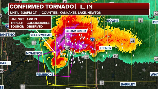
Storm spotters are tracking a large tornado moving out of Illinois and into Indiana now.
This violent, rain-wrapped circulation is currently lofting debris thousands of feet into the air and is moving at highway speeds toward populated areas like St. Anne, Hopkins Park, and Aroma Park.
This is a catastrophic situation for those in the direct path. If you are in these communities, you must get to your lowest-level shelter immediately—a basement or specialized storm cellar is the only safe place during a tornado of this intensity.
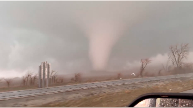
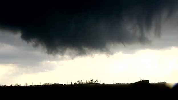
Video shows a massive tornado on the ground in Illinois, bringing large hail and powerful wind gusts.
FOX Weather Exclusive Storm Trackers Corey Gerken and Brandon Copic are on the ground in the middle the violent storm that is tearing through the region.
Huge hail is hammering the Kansas City metro area right now. The National Weather Service issued a Severe Thunderstorm Warning and specifically "tagged" it as destructive, with radar and spotter reports confirming tennis ball-sized hail (2.5 inches).
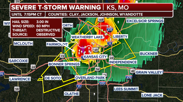
A Severe Thunderstorm Warning has been issued for the Kansas City metro area.
The most significant impacts are currently hitting Overland Park, Olathe, and the KCI Airport area, with the storm line moving northeast at roughly 35–40 mph.
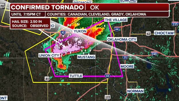
A Tornado Warning has been issued for the Oklahoma City metro area.
The Oklahoma City metro area is currently under a Tornado Warning as a powerful supercell moves through the heart of the state.
A tornado was spotted outside of the city, prompting the National Weather Service in Norman to urge all residents in the path—including those in OKC, Edmond, and Moore—to seek shelter immediately.
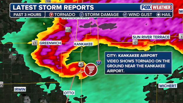
A large and destructive tornado was spotted in Kankakee, Illinois on Tuesday evening.
The National Weather Service confirmed a "large and extremely dangerous" tornado on the ground in Kankakee, Illinois, as of 6:26 p.m. CT.
This violent circulation is moving east at 25 mph, directly impacting the city and surrounding areas like Bradley and Aroma Park.
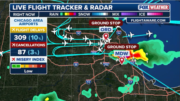
Chicago O'Hare and Midway are under ground stops as storms threaten the metro area.
Travelers at Chicago’s O'Hare International Airport are now facing significant disruptions this evening as the FAA has issued a ground stop due to a nearby severe thunderstorm.
Flights destined to O'Hare are being held at their departure point until the ground stop ends at 8:15 p.m. ET.
If you are scheduled to fly out of O'Hare or Midway tonight, or are heading there to pick someone up, be sure to check your flight status before leaving—delays are expected to climb until the storms clear the city.
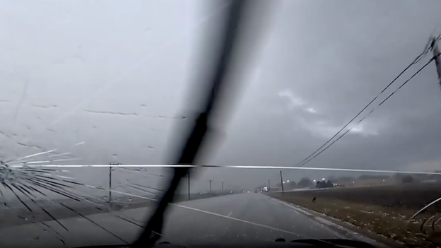
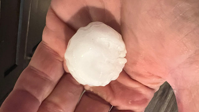
Storm Tracker Corey Gerken's windshield was damaged by huge hail on Tuesday evening.
The power of today's huge hail was put on full display near Kankakee, Illinois, as FOX Weather exclusive storm tracker Corey Gerken's windshield was damaged by massive stones.
Gerken, who was providing live ground truth for FOX Weather at the time, captured the terrifying moment several hailstones—likely exceeding 3.0 inches—fractured the safety glass as he maneuvered through the storm's intense hail core.
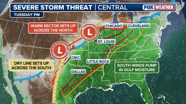
The atmospheric "powder keg" has officially been ignited. This evening, a dangerous, bimodal severe weather outbreak is unfolding across two distinct regions: a Level 4 out of 5 risk zone centered on the Midwest (Illinois and Indiana) and a second volatile corridor stretching across the Southern Plains (Texas and Oklahoma).
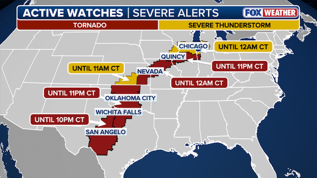
Tornado and Severe Thunderstorm Watches stretch from the Midwest down to Texas.
With over 80 million people in the path of these storms, the primary concern is the development of discrete supercells—isolated, rotating storms that can tap into extreme instability to produce strong, long-track tornadoes (EF-3+) and destructive hail.
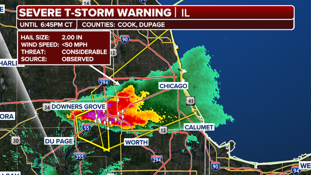
A Severe Thunderstorm Warning is officially in effect for the Chicago metro area as a dangerous thunderstorm roars through northern Illinois.
Radar showing a severe thunderstorm barreling into the Chicago metro area.
The National Weather Service is tracking an intense storm capable of producing 2.00 inch hail and wind gusts exceeding 60 mph, which can cause immediate damage to roofs, windows, and vehicles.
If you are in the warning area—including Cook, DuPage, and Will counties—move indoors and away from windows immediately. With a Flood Watch already active and rain rates hitting 1 to 2 inches per hour, expect rapid ponding on major expressways and significant travel delays at O'Hare and Midway.
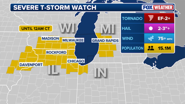
A Severe Thunderstorm Watch has been issued for parts of Illinois, Indiana, Iowa, and Michigan until 12:00 a.m. CT.
The Storm Prediction Center has issued a Severe Thunderstorm Watch for the Chicago area and much of northern Illinois, in effect until 12:00 a.m. CT.
This watch signals that the "battle zone" we've been tracking—where chilly lake-cooled air meets record-breaking inland warmth—is now primed for high-impact weather.
While the tornado risk is most concentrated south of I-80, everyone in the Chicago metro needs to be on high alert for destructive hail and wind gusts that could snap tree limbs and trigger power outages.
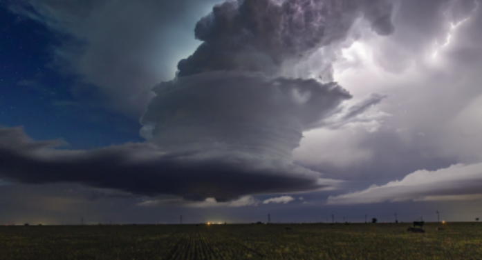
New imagery from the GOES-19 satellite is providing a stunning—and sobering—view of the severe weather outbreak currently unfolding across the Midwest.
From its orbit high above Earth, the satellite captured the supercell thunderstorm that produced a tornado in Illinois towering into the upper atmosphere.
GOES East satellite captured an image of the storm that produced a tornado as it moved over Illinois.
These "overshooting tops" seen from space are a direct signature of intense updrafts, which are the engines driving the tornado-producing storms on the ground.
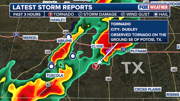
A brief tornado was spotted near Potosi, Texas on Tuesday evening.
A storm chaser spotted a brief tornado southeast of Potosi, Texas on Tuesday evening.

A Severe Thunderstorm Watch has been issued for portions of Kansas until 11:00 p.m. CT.
The Storm Prediction Center has issued a Severe Thunderstorm Watch for southern Kansas until 11:00 p.m. CT as a cold front begins to slice into the region's humid air.
The watch area—including Wichita, Hillsboro, and Arkansas City—is on alert through the evening for storms capable of producing golf ball-sized hail and wind gusts up to 80 mph.
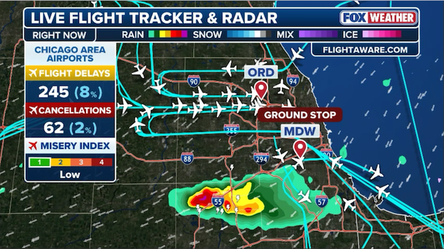
The Federal Aviation Administration has issued a ground stop for Chicago's Midway airport until 7:30 p.m. ET.
Travelers at Chicago’s Midway International Airport are facing significant disruptions this evening as the FAA has issued a ground stop due to nearby thunderstorms.
With intense lightning, heavy rain, and the threat of hail moving directly over the airfield, flights destined to Midway are being held at their departure point until the ground stop ends at 7:30 p.m. ET.
The timing of these storms couldn't be worse, hitting during the peak evening travel window and causing a ripple effect of delays and cancellations for Southwest Airlines and other carriers.
If you are scheduled to fly out of Midway tonight, or are heading there to pick someone up, be sure to check your flight status before leaving—delays are expected to climb until the storms clear the city.
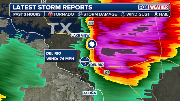
A 74 mph wind gust was recorded near Del Rio, Texas as a dangerous storm barreled through the area.
A dangerous severe thunderstorm is currently tearing through the Del Rio, Texas area, bringing life-threatening conditions to the Rio Grande border.
Meteorologists have confirmed that this intense supercell is producing 70+ mph winds and is capable of producing softball-sized hail (up to 4 inches in diameter).
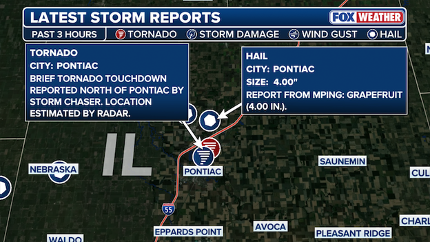
Grapefruit-sized hail was reported north of Pontiac, Illinois as a tornado briefly hit the area.
The explosive development we've been tracking has turned destructive in central Illinois, where giant, grapefruit-sized hail recently blasted the Pontiac area.
FOX Weather exclusive storm tracker Brandon Copic on the scene captured a brief tornado spinning up just north of town, lofting debris into the air as the storm intensified rapidly.
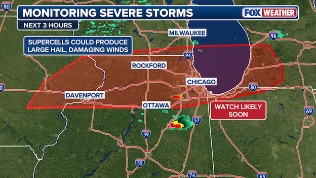
Forecasters are monitoring northern Illinois and Chicago for an increase in the severe storm threat this evening.
The risk for destructive hail and damaging winds is ramping up across Chicago and northern Illinois as a powerful cold front collides with record-breaking spring warmth.
While the tornado threat is most concentrated south of I-80, areas to the north—including the city and the O'Hare corridor—are in the crosshairs for baseball-sized hail and straight-line winds exceeding 70 mph.
Even if it feels chilly where you are, the atmosphere just a few thousand feet up is extremely volatile, meaning storms can still drop massive ice stones through that cool surface layer.
The Storm Prediction Center says it will issue a Severe Thunderstorm or Tornado Watch for the region soon.
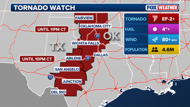
A Tornado Watch has been issued for much of Oklahoma and North Texas until 11 p.m. CT.
The Storm Prediction Center has just issued a Tornado Watch for much of Oklahoma and North Texas until 11:00 p.m. CT as a volatile weather setup takes hold across the Southern Plains.
With a dryline sharpening to the west and high-octane moisture surging north from the Gulf, the atmosphere is officially primed for explosive storm development.
Forecasters are warning that any storms firing this evening will have the potential to produce not only isolated tornadoes but also destructive hail larger than 3 inches in diameter—roughly the size of softballs.
The watch area includes areas west of the Dallas-Fort Worth metroplex, Oklahoma City, and Lawton, extending through the evening hours as a line of storms is expected to sweep eastward.
A separate Tornado Watch remains in effect across Central and West Texas until 10:00 p.m. CT.
The Storm Prediction Center says it will likely issue a Tornado Watch for portions of Oklahoma and Texas in the hours ahead.
The Storm Prediction Center says conditions are becoming more favorable for severe weather across Oklahoma and Texas at this hour.
A Tornado Watch is likely to be issued for portions of the Dallas-Fort Worth Metroplex and nearby communities in the next hour or two.
Exclusive storm tracker Brandon Copic captured the tornado on camera north of Pontiac, Illinois.
FOX Weather exclusive storm tracker Brandon Copic reports the first tornado of the day just spun up north of Pontiac, Illinois.
The twister lofted some small debris into the sky, but no significant damage from the short-lived tornado.
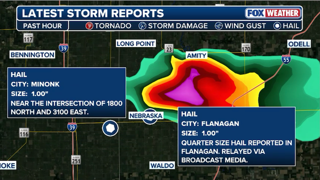
Quarter-sized hail has been reported from a severe storm charging east across Illinois.
As a powerful storm charges east across the Midwest, damaging hail is already hammering parts of Illinois, with some areas reporting stones to 1 inch in diameter.
The Storm Prediction Center has officially issued a Tornado Watch for a broad swath of the Midwest, including northern and central Illinois and northwest Indiana, valid until 11:00 p.m. CT.
This watch comes as a potent storm system collides with an unseasonably warm and humid airmass, creating a powder keg atmosphere.
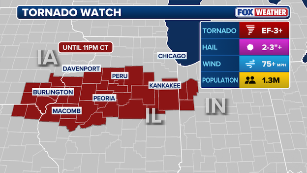
A Tornado Watch has been issued for portions of Illinois, Indiana, and Iowa until 11 p.m. CT.
Forecasters are particularly concerned about the potential for intense tornadoes (EF-3 or higher), which could be long-tracked and fast-moving.
The primary threat will begin with discrete supercells—individual, rotating storms—that are expected to fire up in the hours ahead.
As we lose the daylight, these storms may transition into a powerful line, but the risk of nighttime tornadoes remains high due to a strengthening low-level jet stream.
Make sure you have multiple ways to receive warnings tonight, especially ones that can wake you up, as these storms will be moving through a region still recovering from last week's historic weather.
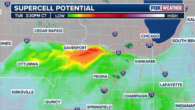
Analysis shows conditions are very favorable for supercell thunderstorms to develop across the Midwest.
The atmospheric lid has officially been removed. For the last several hours, a layer of warm air aloft—known to meteorologists as the cap—has been preventing storms from forming despite record-breaking heat at the surface.
But now, that resistance has vanished and we are now seeing explosive thunderstorm development over Illinois, with lightning increasing as these cells punch through the upper atmosphere.
When the cap breaks like this, it’s often compared to shaking a soda bottle and then unscrewing the cap; the stored energy is released all at once.
Because the air near the ground is so rich with Gulf moisture and temperatures have climbed into the 80s, these initial storms are rapidly becoming supercells.
These are individual, rotating storms that don't have to compete for fuel, making them the most dangerous type of weather system.
If you are in the path of these developing cells—particularly near the I-80 and I-55 corridors—you need to move into your "weather-aware" mode immediately.
A stationary front is creating a battle zone where dangerous storms will develop through this evening.
A dramatic battle zone is forming south of the Chicago metro this afternoon as a powerful lake breeze boundary collides with record-breaking warm air.
This boundary is carving a sharp line through the region: north of the front, lake-cooled air has temperatures stuck in the 40s, while just a few miles to the south, it feels like mid-summer with temperatures climbing into the 70s and 80s.
This 30-degree temperature difference isn't just a weather curiosity—it is the primary tripwire for explosive storm development.
This boundary is the focal point for intense supercells that can tap into the extreme temperature contrast to create extra spin.
FOX Weather forecasters are particularly concerned that any storms moving along or just south of this line will have an increased risk of becoming long-track tornadoes.
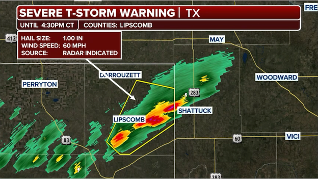
A Severe Thunderstorm Warning has been issued for Lipscomb County in Texas.
The National Weather Service has issued its first Severe Thunderstorm Warning of the afternoon for the Texas Panhandle.
Remember, a warning means severe weather is imminent or is already occurring.
A man remains missing in Indiana after floodwaters swept away his truck Monday. A passenger escaped through a window and clung to a tree vine until first responders arrived on the scene, the Martin County Sheriff’s Office said.
After days of heavy rain a Flood Warning was issued for numerous areas near the White River, the location of the incident that is prone to flooding.
At the time of the flooding, according to the National Weather Service, the White River was at a moderate flood stage, resulting in the inundation of structures and roads near stream.
At 2:37 p.m. on Monday, the passenger that escaped the vehicle called 911 while clinging to a tree to stay afloat. Responders from the Shoals Volunteer Fire Department and Martin County Sheriff’s Department launched a boat and rescued the passenger, though the driver of the vehicle remained missing.
Indiana Conservation Officers are still searching for the man after his truck was swept off Spout Springs Road just south of Shoals.
Surface searches and sonar are being used to locate the driver, James Petty, 82, of Fortville and the vehicle.
The area is still under a Flood Warning, as additional rainfall is expected through the week is expected, hindering search efforts for the missing man as swift moving water conditions persist.
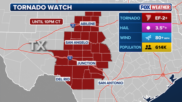
A Tornado Watch is now in effect for portions of Texas until 10:00 p.m. CT.
The Storm Prediction Center has officially issued a Tornado Watch for a large portion of West and Central Texas until 10:00 p.m. CT, as a powerful cold front and dryline begin to slice into a record-warm, humid airmass.
This watch area—which includes cities like Del Rio, Abilene, and Kerrvile, and extends toward the Hill Country—is on high alert for explosive thunderstorm development through the evening hours.
The FOX Forecast Center warns that any storms that fire up along this boundary will quickly become supercells, the most dangerous type of rotating thunderstorm.
Softball-sized hail, a few tornadoes, and destructive winds to 80 mph are likely in the watch area.
Michigan State Police, Emergency Management and Homeland Security Division officials are continuing damage assessments after Friday's deadly tornado.
Authorities said teams of volunteers are stepping in to help clean up.
The National Weather Service confirms that an EF-3 tornado touched down in Union City. The powerful storms left a trail of widespread destruction, with homes and communities damaged, multiple injuries reported and several fatalities confirmed.
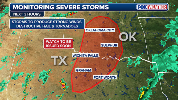
The Storm Prediction Center is preparing to issue a Tornado Watch for a large portion of northern and central Illinois and northwest Indiana in the coming hours.
This move follows an update where forecasters noted that clouds are bubbling up over Iowa and western Illinois at this hour, a sign that the atmosphere is becoming more unstable.
The Storm Prediction Center says it will issue a Tornado Watch for parts of Illinois and Indiana in the next couple of hours.
With dew points surging into the 60s and wind shear increasing, the atmosphere is officially primed for the development of dangerous supercell thunderstorms capable of producing intense tornadoes (EF-3 or higher) and very large hail.
All eyes are on Texas this afternoon as meteorologists monitor the dryline—a sharp boundary separating dry desert air to the west from the soup-thick humidity of the Gulf to the east. This boundary is the primary tripwire for storm development today across Texas.
As the afternoon sun heats the ground, it will begin to erode the cap (a layer of warm air that acts like a lid), potentially allowing explosive thunderstorms to erupt along the I-35 corridor and the Edwards Plateau.
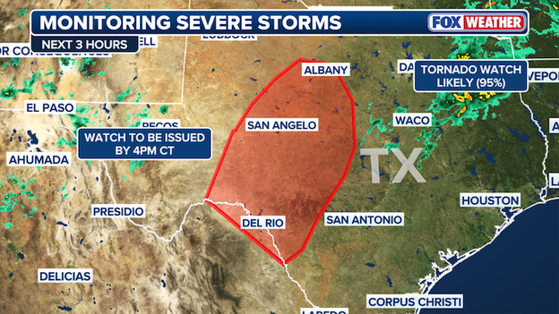
The Storm Prediction Center says it will issue a Tornado Watch for Texas by late afternoon.
Storms are expected to fire up between 3:00 p.m. and 6:00 p.m. CT. Once these storms pop, they will have access to an incredibly unstable environment, allowing them to quickly grow into powerful supercells.
The Storm Prediction Center says it will issue a Tornado Watch for the region by late afternoon. Remember, a watch means conditions are favorable for tornadoes and severe weather to develop and that you should stay "weather aware." A warning is issued when severe weather is imminent or already occurring.
While the initial storms may be isolated, they will be capable of producing destructive, softball-sized hail, 70 mph winds, and a few tornadoes. Forecasters say the tornado threat will actually increase during the evening hours.
Residents from Austin and San Antonio over to Del Rio should keep a close watch on the western horizon; in Texas, a clear blue sky can turn into a towering thunderstorm in a matter of minutes once storms initiate.
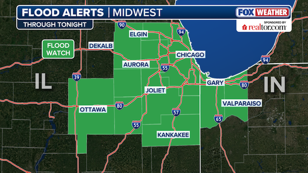
The National Weather Service has issued a Flood Watch for the Chicago metro area through tonight.
While much of the focus today is on the tornado and hail threat, a Flood Watch has been issued for the Chicago metro area as a wave of intense tropical moisture moves in.
The FOX Forecast Center is concerned about a phenomenon called training, where multiple thunderstorms follow the same path like cars on a train track.
With the ground already saturated from recent spring rains, this repeat storm activity could quickly overwhelm city drainage systems and lead to significant street flooding during the evening commute.
The National Weather Service predicts that some areas could see rain rates of 1 to 2 inches per hour within the strongest storms. For a concrete-heavy city like Chicago, that volume of water has nowhere to go, often triggering flash flooding very quickly.
If you are traveling on the Kennedy, Dan Ryan, or Eisenhower expressways tonight, be alert for standing water in low-lying areas and underpasses. Remember the golden rule of flood safety: "Turn around, don't drown"—it only takes six inches of moving water to knock you off your feet and just a foot to sweep a vehicle away.
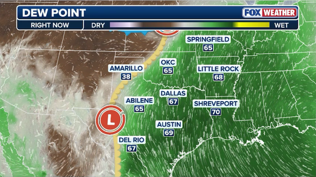
Dew point temperatures are climbing into the 60s and 70s as warm, humid air surge north across the Heartland.
Right now, the atmosphere is fueling up as moisture surges north from the Gulf of America.
This surge of warm, humid air is pushing dew points into the 60s and 70s across the Heartland, providing the high-octane energy needed to power today's expected severe storm outbreak.
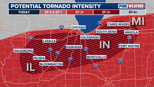
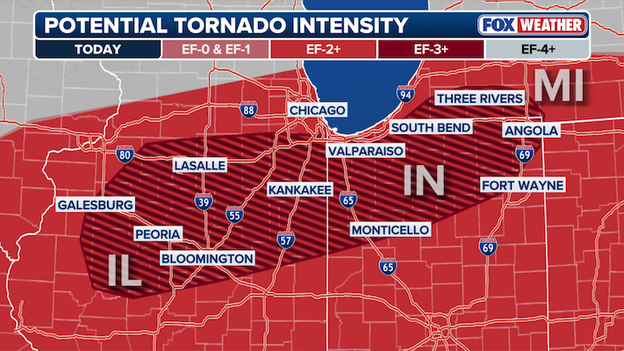
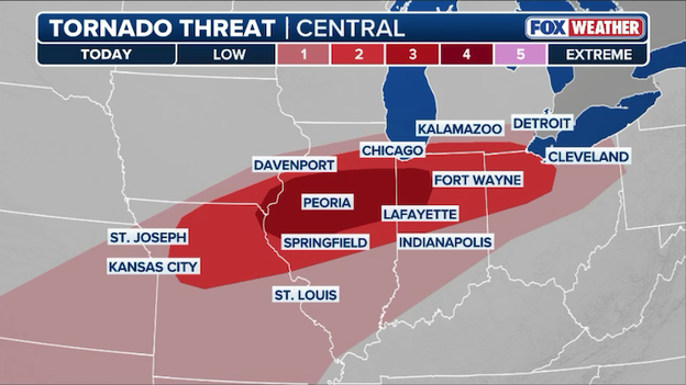
Intense tornadoes (EF-3) will be possible across Illinois and Indiana through the evening.
The atmosphere is primed and ready for a dangerous evening across the Midwest and the Storm Prediction Center issued a rare Level 4 of 5 threat area for a corridor stretching from northern Illinois into northwest Indiana.
FOX Weather meteorologists are warning that all severe hazards are on the table tonight, including the potential for intense tornadoes (EF-3 or higher), damaging wind gusts up to 70 mph, and large hail.
As we head into the evening hours, the primary concern shifts to the nighttime threat. A strengthening low-level jet—a fast-moving stream of air just above the surface—will continue to pump warm, moist air into the region, allowing storms to maintain their intensity long after sunset.
Nighttime tornadoes are statistically twice as deadly as those that occur during the day because they are difficult to see and often strike while people are asleep.
Meteorologists in the FOX Forecast Center are keeping a close eye on new computer model data as it pours in this afternoon.
Right now, the latest HRRR (High-Resolution Rapid Refresh) model is showing a particularly aggressive scenario near the Chicago metro area.
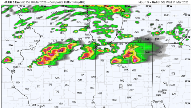
High-Resolution Rapid Refresh (HRRR) model showing explosive storm development south of Chicago this evening. (Source: WeatherBELL)
This high-speed computer model, which updates every single hour, is suggesting explosive thunderstorm development along a sharpening warm front that is draped across northern Illinois.
While the morning started with dense fog and cooler temperatures, the HRRR indicates that as the cap (the atmospheric lid) breaks later today, storms will ignite rapidly and intensify into powerful supercells. At this time, it appears the worst storms will begin to fire up after 5:00 p.m. CT.
It now appears that a corridor of extreme instability will form just south of I-80, allowing storms to tap into warm, humid air near the ground, which is the key ingredient for tornado development.
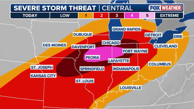
A rare Level 4 of 5 severe weather threat zone has been issued by the Storm Prediction Center for Illinois and Indiana today.
The Storm Prediction Center (SPC) has just upped the ante, upgrading parts of northern Illinois and northwest Indiana to a Level 4 out of 5 for severe weather today.
This rare and urgent upgrade signals that a regional outbreak of severe storms and tornadoes is increasingly likely.
A Level 4 risk is a major red flag—it means the atmospheric ingredients have reached a volatile peak, significantly increasing the confidence that we will see multiple strong tornadoes and widespread destructive hazards.
The bullseye for this heightened threat includes the Chicago metro area, Rockford, and Gary, extending toward the South Bend region.
Meteorologists are tracking a dangerous overlap of high-octane humidity and extreme wind shear that could support long-track tornadoes—those that stay on the ground for extended periods.
In addition to the tornado threat, this Level 4 zone is at risk for giant hail (exceeding 2 inches) and damaging wind gusts over 75 mph.
The FOX Forecast Center says the last Level 4 of 5 threat zone was issued by the SPC on July 28, 2025. Data from the Storm Prediction Center suggests this threat level is only issued about 14 times each year.
Mark Roraback was asleep when a tornado tore through his home in the middle of the night on Saturday. The EF-2 tornado destroyed the house, but fortunately, Roraback and a guest staying with him were unharmed.
Mark spoke with FOX Weather Command on Tuesday.
With a significant severe weather threat looming over North Texas, the National Weather Service in Fort Worth is taking extra steps to get a high-definition look at the atmosphere.
Meteorologists will launch a special weather balloon—an additional flight on top of the standard twice-daily releases—to sample the air ahead of the expected storm development.
These extra launches are a major signal that the potential for severe weather is elevated, as they provide real-time data that computer models and local forecasters use to fine-tune their predictions.
Why "special" launches matter
- Model accuracy: This fresh data is fed directly into high-resolution weather models, making the radar simulations you see on TV much more accurate.
- Warning lead time: By knowing the exact state of the atmosphere, NWS can issue Tornado or Severe Thunderstorm Watches with greater confidence and precision.
- Real-time analysis: Meteorologists can see exactly how much fuel (moisture) is available for storms to use once they ignite this afternoon.
"The National Weather Service is predicting strong storms could pass through Kane County late this afternoon (3/10/26) into the evening hours. Stay on top of changing weather conditions by signing up for Kane County’s free public safety alert system."
After a record-breaking Monday that saw the temperature climb into the low 70s, Chicago is experiencing a dramatic reality check today.
Temperatures are tumbling back into the 40s and 50s as a sharp cold front cuts through the region, acting as the tripwire for an arriving severe weather threat.
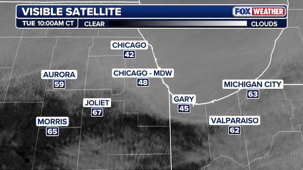
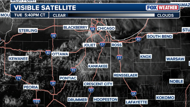
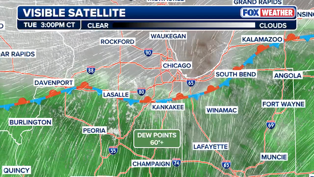
Visible satellite shows clouds forming in the wake of a cold front sliding south through the Chicago metro area.
While the city is feeling the chill right now, don't let the cooling air fool you—the setup is actually priming the atmosphere for damaging hail.
That front will serve as the focus for powerful storms to erupt later this afternoon and evening. As storms move north of the front into Chicago, they'll become "elevated," surviving above that layer of cool, stable air near the ground, drawing their energy from warmer air higher up in the atmosphere rather than from the surface.
Storms that move into this colder air will be capable of dropping hail and torrential rain well after sunset.
If you are north of I-80, the dropping temperatures signal that your primary risk is this windshield-shattering hail, while areas just to the south remain in the "warm sector" where the tornado threat is highest.
Evan Bentley, a Warning Coordination Meteorologist at the Storm Prediction Center, discussed Tuesday's elevated severe weather risk for the Midwest and Texas with FOX Weather Command.
The SPC has placed parts of north-central Illinois and extreme southern Michigan in the risk area for intense (EF-3+) tornadoes.
This is the first time this level of tornado threat has been issued since the SPC debuted its revamped severe weather forecast last week.
The SPC also placed part of the Texas Plains under the highest threat for very large hail. It also marks the first forecast that has explicitly called for softball-size hail since last week's introduction of Conditional Intensity Groups, which aim to better highlight the types of severe weather people can expect.
The atmosphere over the central United States is undergoing a dramatic transformation this morning, setting the stage for a dangerous bimodal severe weather outbreak. This means instead of one single storm area, we are tracking two distinct bullseyes where the ingredients for violent weather are most concentrated: the Mid-Mississippi Valley (including Chicago and St. Louis) and the Southern Plains (focusing on West Texas).
A split-flow pattern in the jet stream is the culprit, pulling one system across the northern Rockies and another through Mexico. As these two features phase together, they are opening the floodgates for a surge of high-octane moisture from the Gulf of America, creating a highly unstable environment across a massive 1,500-mile stretch of the country.
Severe thunderstorms will erupt across the central U.S. today as ingredients come together for volatile weather.
In the Midwest, the primary concern is the interaction between a sharpening stalled front and a strengthening low-level jet—a river of fast-moving air just above the surface.
This jet will act as a massive twist in the atmosphere, significantly elongating the hodograph (the tool we use to measure how winds change with height).
This setup is classic for the development of discrete supercells—individual, rotating storms that don't have to compete for energy.
South of the front, where temperatures are soaring into the 80s, these supercells will have access to over 2,000 J/kg of CAPE (Convective Available Potential Energy). You can think of CAPE as the "explosiveness" of the air; anything over 1,000 is high, so today’s values are well into the danger zone, supporting strong to intense tornadoes (EF-2 or higher) and hail larger than 2 inches.
Meanwhile, down in Texas, the threat is being driven by a dryline—the sharp boundary where bone-dry desert air from the west crashes into the humid air to the east.
Because the air high above Texas is exceptionally cold today, any storm that pops along this boundary will have incredible upward speed. This allows hail stones to stay suspended in the frigid upper atmosphere for a long time, growing into massive, softball-sized chunks before gravity finally pulls them down.
While the tornado risk in Texas is more isolated than in the Midwest, the sheer size of the hail and the potential for 70 mph straight-line winds as storms merge into a line this evening makes this a life-safety event for the Lone Star State.
As a severe weather outbreak targets the Midwest today, forecasters are warning that EF-3 tornadoes are a distinct possibility.
The Enhanced Fujita (EF) Scale is the tool meteorologists use to rate a tornado's intensity, but it isn't based on live wind measurements; instead, it's a damage scale that uses 28 different indicators—like houses, schools, and trees—to estimate how fast the winds were blowing.
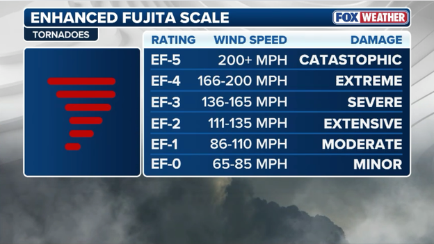
The Enhanced Fujita Scale rates the strength of tornadoes based on the damage they produce.
An EF-3 rating is classified as 'severe' damage, with estimated 3-second wind gusts between 136 and 165 mph.
At this intensity, entire stories of well-constructed homes can be destroyed, heavy cars can be lifted and thrown, and large buildings like shopping malls can sustain significant structural damage.
Because these ratings are based on the destruction left behind, National Weather Service survey teams go out in the days after a storm to determine if the damage matches the fingerprints of an EF-3 or higher.
Chicago is bracing for a volatile afternoon and evening as severe thunderstorms take aim on the region. Following a morning of dense fog and record-breaking warmth, the atmosphere is now energizing for a potential severe weather outbreak.
The Storm Prediction Center has placed a large portion of the metro area under a Level 3 of 5 risk zone for severe storms, with the primary threats being hail the size of golf balls and damaging wind gusts over 60 mph.

Dangerous storms could drop large hail and produce damaging winds in Chicago by early evening. (Source: WeatherBELL)
The most dangerous window for the Windy City is expected between 4:00 p.m. and midnight.
While everyone in the region should be on alert, meteorologists are particularly concerned about areas south of I-80, including Kankakee and Joliet, where the ingredients for rotating storms are strongest. In these southern suburbs, the risk includes not only destructive hail but also the potential for violent tornadoes.
As a stationary front settles near the city, it will act as a dividing line: North of the front (including the city center), the main threat will be large hail that could dent cars and damage roofs. South of that line, all hazards—including tornadoes and flash flooding—are on the table.
The Storm Prediction Center has upped the ante for today's tornado threat, officially highlighting a risk for violent tornadoes (EF-3 or higher) across parts of the Midwest.
This heightened alert covers a corridor from northern Illinois to northern Indiana, where the atmospheric ingredients are coming together for a dangerous late-afternoon outbreak.
The Storm Prediction Center is warning that 'intense' (EF-3) tornadoes are possible today in Illinois and Indiana.
Right now, a powerful storm system is brewing as a shortwave trough—a fast-moving disturbance high in the atmosphere—pushes toward the Midwest.
This system is pulling a surface low across the Heartland, which is sharpening a stalled weather front stretching into southern Wisconsin and Michigan. Think of this front like a battle line: to the north, winds are cold and bracing, while to the south, the atmosphere is fueling up with record warmth and humidity.
As the air converges or crashes together along this line, it will force the air upward, acting as the spark to ignite explosive thunderstorms by late afternoon.
The air south of this boundary is becoming unstable, meaning it is loaded with CAPE—essentially the high-octane gasoline that thunderstorms use for power. With temperatures in the 80s and high humidity, any storm that forms will likely become a supercell, a dangerous, rotating thunderstorm capable of all severe hazards.
Forecasters are particularly concerned with what they're seeing in the hodographs, which is a technical way of measuring how the wind changes speed and direction as you go higher in the sky.
As evening approaches, this twist in the atmosphere will increase significantly, raising the risk for strong to intense tornadoes and giant hail larger than 2 inches in diameter across parts of the Mid-Mississippi Valley and southwest Michigan.
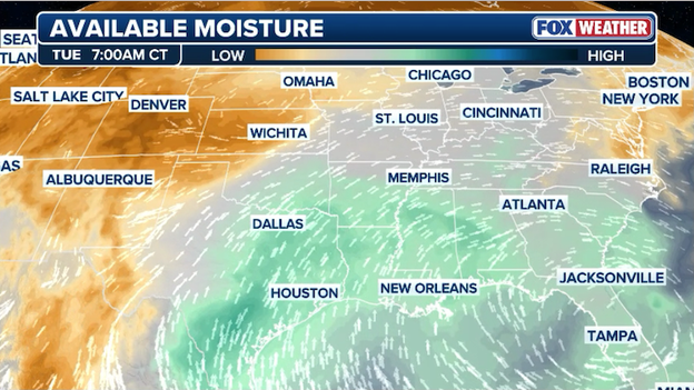
Analysis shows moisture streaming north across the Heartland in advance of today's expected severe weather outbreak.
The atmosphere is fueling up this morning as a powerful low-level jet—a fast-moving ribbon of air just above the earth's surface—acts like a high-speed conveyor belt, streaming rich moisture north from the Gulf of America.
This surge of warm, sticky air is pushing dew points into the 60s across the Heartland, providing the critical energy needed to power today's severe storms.
As this humid air collides with the arriving cold front, it creates a highly unstable environment known as instability.
Think of this Gulf moisture as the high-octane gasoline for the atmosphere; the more moisture we have in place this morning, the more explosive the storms will be once the afternoon heating provides the spark.
FOX Weather breaks down the deadly threat behind nighttime twisters. For those in today's threat zone, now is the time to prepare.
Michigan is back on high alert today as a new, potent storm system threatens the same communities still reeling from last week’s historic violence.
This renewed risk comes just days after the National Weather Service confirmed that an EF-3 tornado devastated Union City on March 6, marking the earliest EF-3 or stronger tornado ever recorded in Michigan's history.
FOX Weather meteorologist Haley Meier is LIVE in Michigan as communities recover ahead of today's looming severe storm threat.
The Lone Star State is in for a bumpy Tuesday as a volatile weather setup takes aim at the Southern Plains.
While the Midwest is bracing for a tornado threat, the FOX Forecast Center is warning Texans that giant, destructive hail will be the headline story.
The trouble starts this afternoon along the dryline—the boundary where dry, desert air from the west pushes into the humid, sticky air from the Gulf. This clash is expected to ignite a series of powerful supercell thunderstorms that could drop ice stones ranging from the size of golf balls to hen eggs or even baseballs.
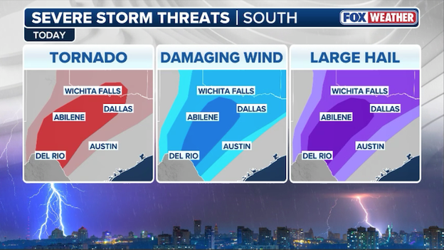
Dangerous storms are forecast to fire up across the Lone Star State today with tornadoes, damaging winds, and destructive hail all possible.
The highest risk for these windshield-shattering stones stretches from the Texas Panhandle down through the Rio Grande, including cities like Midland, Abilene, and Del Rio.
Because the air high above the ground is exceptionally chilly today, these storms have the perfect environment to keep hail suspended in the sky until it grows to dangerous sizes.
While the storms may start out isolated, they will likely merge into a fast-moving line by early evening, shifting the threat to 70 mph wind gusts and heavy rain for the Dallas-Fort Worth metroplex.
Just days after a deadly stretch of weather, the FOX Forecast Center is tracking a classic spring-time setup that places millions of Americans in the crosshairs of another severe weather outbreak.
While we are watching a massive area from the Great Lakes down to the Rio Grande, two specific bullseyes have emerged where the ingredients for strong tornadoes (EF-2 or higher) are most concerning: a corridor from northeast Missouri through northern Illinois and into northwest Indiana, and a separate zone across the Texas Plains.
A recipe for tornadoes
To get a tornado, you need a very specific set of ingredients to come together at exactly the same time. Think of it like a recipe where the oven is the heat of the day and the ingredients are:
- Fuel (instability): We have record-breaking warmth and high humidity (dew points in the 60s) surging north from the Gulf. This creates "CAPE," which is essentially the octane level of the atmosphere. Today, that octane is very high, meaning any storm that starts has plenty of energy to grow tall and strong.
- The spark (lift): Two separate troughs, or dips in the jet stream, are acting as the spark. These systems pull the air upward, breaking the cap—a layer of warm air that normally acts like a lid to keep storms from forming. Once that lid pops this afternoon, storms will explode rapidly.
- The spin (wind shear): This is the most critical part for tornadoes. Today, winds near the ground are blowing from the south, while winds higher up are screaming out of the west. This change in wind speed and direction with height is called wind shear. It creates a rolling motion in the atmosphere that a strong storm can stand up vertically, causing the entire thunderstorm to rotate.
Strong tornadoes are possible today with the 'bullseye' stretching across Illinois and Indiana.
Where the risk is highest
In the Midwest, the primary concern is the development of discrete supercells—isolated, rotating giants that travel on their own.
Because they aren't crowded by other storms, they can soak up all the atmospheric energy for themselves, which is why they are the most likely to produce long-track, strong tornadoes.
In Texas, while the tornado risk is more isolated, the dryline (the boundary between desert air and humid air) will trigger storms capable of baseball-sized hail and intense wind gusts.
Millions of residents in some of America’s largest metro areas are facing a high-stakes weather day as a massive storm system takes aim at both the Midwest and the Southern Plains.
In Chicago, the record-breaking 70-degree warmth of Monday is being replaced by a much more menacing setup. The Storm Prediction Center has placed the region under a Level 3 of 5 severe storm threat, with the most dangerous conditions expected to develop between 4 p.m. and 6 p.m. CT.
While the city itself is on high alert for damaging winds and large hail, the threat of strong tornadoes (EF-2 or higher) is particularly elevated for communities just south of I-80.
This is a 'pop the cap' scenario, where the spring-like heat acts as fuel for explosive supercell development that could impact the evening commute and persist well into the night.
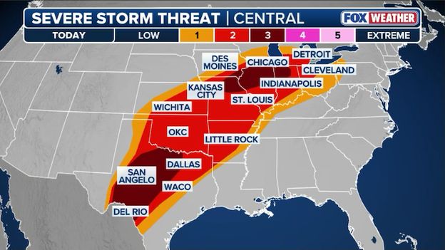
Severe storms are expected to erupt from the Great Lakes to the U.S.-Mexico border today with strong tornadoes and giant hail possible.
Farther south, Dallas and the North Texas region are bracing for a different but equally dangerous flavor of severe weather.
As a dryline sharpens across West Texas, individual discrete storms are expected to ignite and charge toward the I-35 corridor.
For Dallas, the primary concern today is giant, destructive hail that could reach the size of baseballs, along with the risk of a few tornadoes.
Unlike typical storms that weaken after sunset, a surging low-level jet will likely keep these storms breathing long after dark, increasing the risk for nocturnal tornadoes—which are notoriously difficult to see and twice as deadly.
Whether you are in the Windy City or the Big D, today is the day to have your FOX Weather App push notifications enabled and a clear plan to reach your safe space the moment a warning is issued.
You’ve reached the beginning of this live coverage.