Live updates: Severe storms slam Southeast in powerful conclusion to multiday threat
Live updates: Severe storms slam Southeast in powerful conclusion to multiday threat
Download the AppTornado Watch expands after radar-confirmed tornadoes detected across Alabama, Georgia
View postCoverage for this event has ended.
The Mississippi Emergency Management Agency reported Thursday that 1 person was killed and 3 others were hurt after severe thunderstorms swept through Lawrence County Wednesday.
According to the FOX Forecast Center, the strongest storms moved through the area around 8 p.m. local time, with rain persisting into early Thursday.
More than 40,000 customers were still without power Thursday morning, with other damage concentrated in Amite, Lincoln, Smith, Pike and Walthall counties.
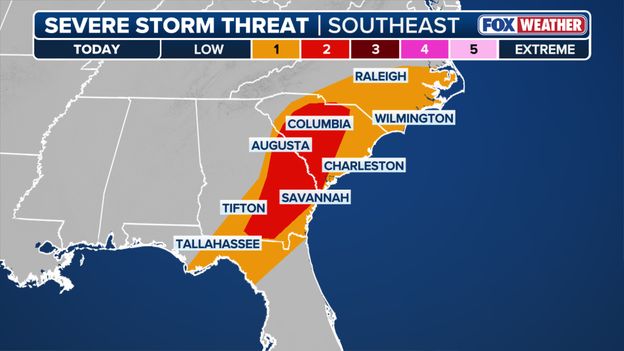
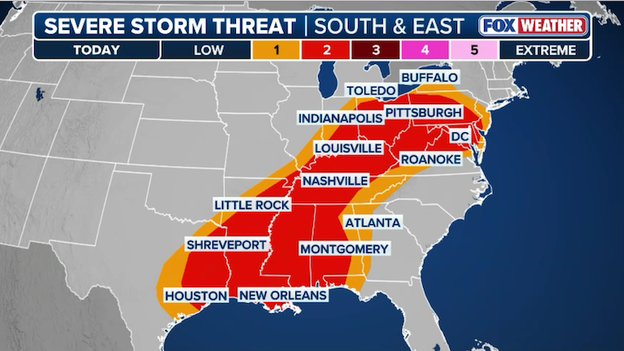
The Storm Prediction Center has increased Thursday's severe weather threat to a Level 2 out of 5.
The severe storms rumbling across the Southeast are capable of producing an EF-2 tornado through early Thursday afternoon before finally moving off the coast.
Thursday Severe Weather Threat
Power outages have spiked across Louisiana, Mississippi, Alabama and Georgia Thursday morning, as a line of severe thunderstorms blasts through the region.
Wind gusts of up to 55 mph have been reported, and the National Weather Service has received numerous reports of downed trees and power lines.
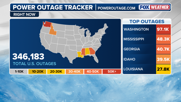
Power Outage tracker
The National Weather Service survey found that a preliminarily rated EF-3 tornado formed near Aroma Park, Illinois, Tuesday night.
The tornado was on the ground for 36.6 miles, tracking from near Aroma Park to near DeMotte, Indiana. This path crossed Lake Village, Indiana, where two people were killed.
FOX Weather Correspondent Katie Byrne is in Aroma Park with the latest.
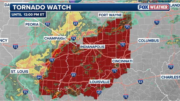
Active Tornado Watches
A Tornado Watch includes parts of South Carolina after a powerful line of severe thunderstorms marched across Alabama, Georgia and the Florida Panhandle.
At least four radar-confirmed tornadoes have been detected this morning in Alabama and Georgia.
According to data from poweroutage.com, power outages in Louisiana are skyrocketing as severe storms roll through parts of the South.
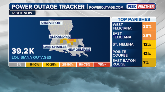
Power Outage Tracker using data from poweroutage.com
Outages have been reported across numerous parishes, as nearly 40,000 outages have been reported across Louisiana.
The storms have already prompted multiple Tornado Warnings, and Tornado Watches remain in effect for parts of the region — a sign that conditions are primed for additional dangerous storms.
The National Weather Service warns the severe threat isn’t over yet. With watches and warnings expected to continue into Thursday, people in the warning areas are urged to stay weather-aware as the risk for tornadoes, damaging winds, large hail and flash flooding threatens the Deep South.
The National Weather Service announced that the Knox, Indiana Tornado that spawned the first Tornado Emergency of the year has been rated an EF-2.
The tornado packed an estimated peak wind 115 mph, with a width of 1,000 yards and traveled approximately 14.5 miles.
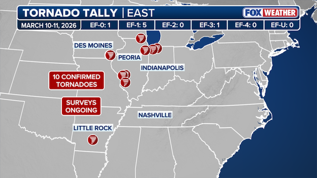
Tornado Tally Map from March 10-11, 2026
A large cone-shaped tornado formed 3 miles northeast of the previous Wheatfield, Indiana tornado, heavily damaging two pole barns and three grain bins at its start, with debris thrown up to half a mile.
It moved northeast, damaging trees, irrigation systems, barns, and homes, crossed SR 39 and later SR 8, and lifted southeast of the Starke County Airport in Knox, Indiana.
The damage path reached just over half a mile wide, with signs of brief multi-vortex activity.
The information in this statement is preliminary and subject to change pending final review of the event and its publication in NWS Storm Data.
As surveys continue, the National Weather Service has confirmed a total of 10 tornadoes from Tuesday’s severe weather outbreak.
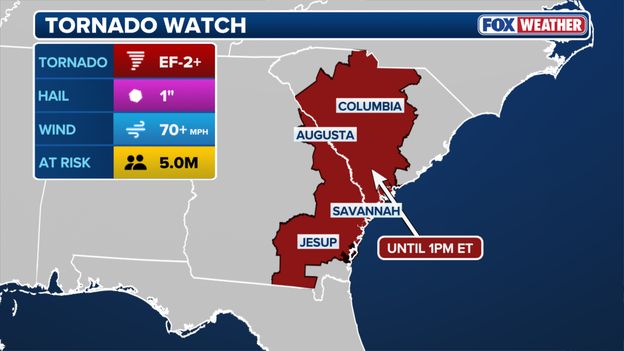
A Tornado Watch has been issued across parts of Alabama, Louisiana and Mississippi until 2 a.m. CDT.
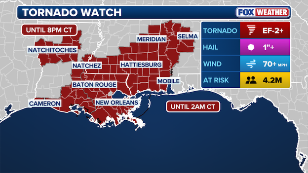
Tornado Watch map
The Watch includes New Orleans, Baton Rouge and Mobile, putting more than 4 million people at risk of potential tornadoes up to EF-2+, hail 1" in diameter and 70 mph wind gusts into Thursday.
Stick with FOX Weather as we continue to monitor severe weather across the U.S.
The National Weather Service said that preliminary reports indicate the strong tornado that ripped through Kankakee, Illinois, was an EF-3.
The dangerous tornado spawned during a severe weather outbreak across the Midwest Tuesday evening, and ensued on a path of carnage, destroying homes and demolishing businesses.
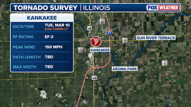
Kankakee Tornado Survey
Preliminary information indicates this tornado began southwest of Kankakee, Illinois, and tracked northeast, dissipating northeast of Roselawn, Indiana.
Along its path, it moved through the southern portion of Kankakee; the northern section of Aroma Park; just south of Sun River Terrace; just north of Hopkins Park; across the southern portion of Lake Village, where officials announced two people died; and through the northern portion of Roselawn.
Peak wind gusts reached 150 mph along Sandbar Road northeast of Aroma Park, which is EF-3 intensity, the National Weather Service said.
A report of hail 6" in diameter were reported in Kankakee, which would set a new Illinois state-record if verified by the National Weather Service.
More information about the tornado start, tornado end, and peak width will be available at a later time after further analysis.
So far, six tornadoes have been confirmed from Tuesday night's severe weather outbreak.
A Tornado Warning has been issued areas in Baltimore and Baltimore City counties in place until 7:45 P.M. EST.
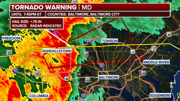
Tornado Warning map
The City of Baltimore is under a Severe Thunderstorm Warning, along with portions of Anne Arundel, Baltimore, and Howard counties.
Damaging wind gusts up to 70 mph and pea-sized hail are possible. More than 1.8 million people across the warned area in Maryland are under threat.
The warning remains in effect until 8 p.m. EST.
Officials provided updates on recovery efforts in Lake Village, Indiana, of the hardest hit areas from Tuesdays severe weather outbreak, where two people died after a damaging tornado moved through the area.
Indiana State Police Lowell Post Sgt. Glen Fifield said in an afternoon update that search teams examined 235 structures in Lake Village on Tuesday. Of those, 106 sustained damage, 32 were destroyed, 24 had minor damage and 18 were classified as "affected."
A home is heavily damaged after being hit by a tornado on March 11, 2026 in Lake Village, Indiana. (Photo by Scott Olson/Getty Images)
“There are other residences, buildings and businesses that do have damage that are not in this staff today, so these are relatively conservative numbers,” Fifield said.
At its peak, Northern Indiana Public Service Company (NIPSCO) reported more than 11,000 power outages related to the severe storms. More than 3,000 customers across three counties remain without power, including 1,244 in Lake Village.
Several roads in Lake Village remain closed for safety reasons. Officials said NIPSCO temporarily restricted search crews from entering certain areas due to unsafe conditions.
During a secondary search, rescue teams combed through heavy debris, downed trees, power lines and destroyed homes in search of additional victims. Fifield confirmed there were no additional fatalities beyond the two deaths previously reported.
Earlier today, Newton County Sheriff Shannon Cothran confirmed the two fatalities were an elderly man and woman from the same family.
Officials also reported seven hazardous materials incidents, all of which have been secured.
The Kankakee County Emergency Management Agency and Highway Department have announced storm debris removal plans for areas impacted by recent storms, excluding the City of Kankakee.
Severe storms ripped through the northwestern Illinois County Tuesday, producing a dangerous tornado that left behind a path of destruction, demolishing houses and scattering debris.
Residents have until Wednesday, March 18, 2026 (one week) to sort and place debris for pickup. Items must be separated into four categories:
- White goods (large appliances)
- E-waste (electronics)
- General construction debris
- Recyclable metals
Debris on the ground, Wednesday, March 11, 2026, from homes along South Sandbar Road following last night's storms in Aroma Park, Illinois. The homes border the Kankakee River. (Stacey Wescott/Chicago Tribune/Tribune News Service via Getty Images)
To maintain traffic flow, all vehicles—including contractors—must park on the side of the road matching house address numbers (even-numbered side on even days; odd-numbered side on odd days).
Residents are also instructed not to place debris against fire hydrants or signs.Officials encourage residents to document disposed items with photos or video for insurance purposes.
For questions, contact the Kankakee County Highway Department at (815) 933-1731.
Tornado Watches scattered across parts of Maryland, Pennsylvania, Virginia and West Virginia through expiring between 5 p.m. to 8 p.m. EDT as a volatile atmosphere fuels the threat for rapidly developing severe storms capable of producing tornadoes, damaging wind gusts and ping-pong sized hail.
Tornado Watch area
More than 10 million in this area are under threat of 70+ mph wind gusts, 1-2" hail and a couple of tornadoes, just a day after dangerous tornadoes ripped through Illinois and Indiana.
To the South, another watch area underscores the range of this severe weather setup. One particularly concerning area stretches from southeast Texas into Louisiana under Tornado Watch until 6 p.m. CST.
Stay with FOX Weather as we continue to monitor these watches and track storms in real time.
Lake Village — one of the communities hardest hit by Tuesday’s severe weather outbreak — has already begun the long road to recovery, just one day after a damaging tornado tore through the town along the Indiana-Illinois border.
In a recent update, Newton County Sheriff Shannon Cothran said, “By now, you’ve probably seen the aerial photographs posted on social media. Hopefully that puts things into perspective the next time you’re upset about a flat tire or a few shingles missing. Please realize that some families in our community have lost everything.”

A dollar store is missing part of its roof on Wednesday, March 11, 2026, following the previous night's tornado along Old 41 Road in Lake Village, Indiana. (Stacey Wescott/Chicago Tribune/Tribune News Service via Getty Images)
County Commissioner Abbey Rossiter said families impacted in Lake Village are seeking donations of cleanup supplies, toiletries, hand tools, wheel barrows and more as the community recovers from the catastrophic damage. Parties interested in donating can do so at the Lake Village Community Center at 9728 N, 300 W, Lake Village, Indiana.
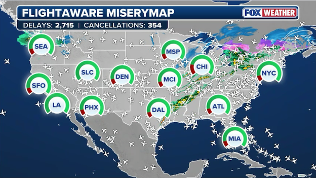
FlightAware MiseryMap showing flight disruptions as thunderstorms charge across the eastern U.S.
Travelers are facing a frustrating afternoon as a massive storm system sweeps across the eastern half of the country, triggering a ripple effect of flight disruptions.
Ground stops are in effect for LaGuardia (LGA) in New York, George Bush Intercontinental (IAH), and Hobby (HOU) Airport in Houston as thunderstorms disrupt flights going in and out of the major hubs.
A ground stop is a safety measure issued by Air Traffic Control that temporarily halts all flights from taking off for a specific airport to prevent gridlock or dangerous landings during severe weather. It essentially hits the "pause" button on the ground at your departure city to ensure that planes aren't circling in dangerous thunderstorms or stuck on a taxiway once they arrive at their destination.
In the Washington, D.C. area, Reagan National (DCA) is also dealing with delays due to thunderstorms in the region.
According to FlightAware, more than 2,700 U.S. flights have been delayed so far today with another 350 canceled altogether.
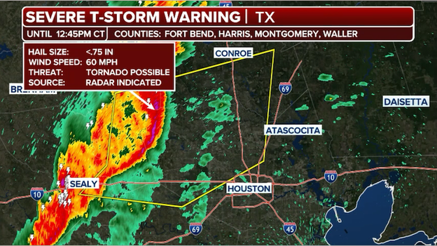
A Severe Thunderstorm Warning has been issued for portions of the Houston metro area until 12:45 p.m. CT.
A powerful line of severe thunderstorms is roaring into the Houston metro area right now, bringing with it the threat of 60 mph wind gusts, frequent lightning, and torrential rain.
A Severe Thunderstorm Warning is in effect for Fort Bend, Harris, Montgomery, and Waller Counties until 12:45 p.m. CT.
Commuters should prepare for major travel delays and localized street flooding, as rain rates could briefly exceed 2 inches per hour. If you are outdoors or at the Houston Rodeo, seek shelter immediately in a sturdy building until the core of the storm passes.
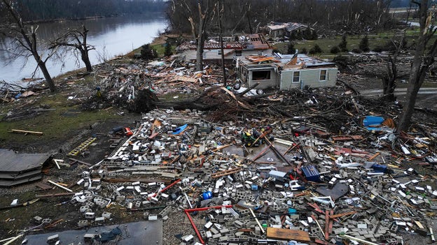
Residents of Kankakee, Illinois were left to survey what remains of their neighborhood.
Homes in the area were reduced to piles of rubble and debris following a powerful tornado that ripped through the area as severe weather continues to move across the country.
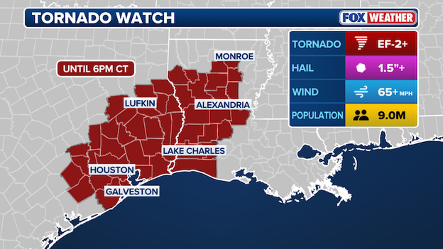
A Tornado Watch has been issued for portions of Texas and Louisiana until 6 p.m. CT.
The severe weather threat is shifting focus to the South this afternoon as the Storm Prediction Center issues a Tornado Watch for portions of East Texas and Louisiana until 6:00 p.m. CT.
This watch comes as a potent line of storms begins to organize ahead of a cold front, fueled by a surge of moisture from the Gulf of America.
While the primary threat remains damaging straight-line winds exceeding 60 mph, the atmosphere is primed for isolated tornadoes and large hail as the system moves through.
People in cities like Houston, Beaumont, and Shreveport should be on high alert through the afternoon. In Louisiana, the most intense activity is expected to reach the Baton Rouge and New Orleans areas later this evening, making this a dangerous after-dark event for much of the state.
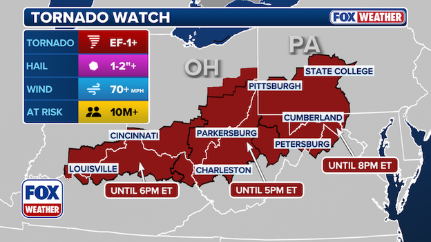
Map showing the new Tornado Watch for parts of Ohio and West Virginia.
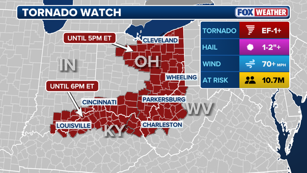
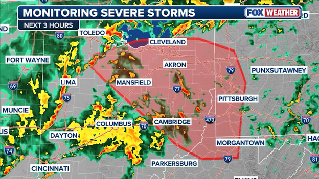
A Tornado Watch has been extended for portions of eastern Ohio, West Virginia, and northeastern Kentucky until 6:00 p.m. ET.
The watch comes as a potent cold front interacts with record-setting warmth across the region, creating an environment primed for rotating thunderstorms.
While damaging straight-line winds remain the primary concern for the afternoon, the National Weather Service warns that the atmospheric spin is sufficient for isolated tornadoes to form within the line of storms pushing through the I-70 and I-80 corridors.
While the tornado threat is grabbing headlines, another hidden danger is unfolding today: the risk of sudden, life-threatening flash flooding.
From the Gulf Coast up to the Ohio Valley and into New York, the atmosphere is loaded with moisture, and the way these storms are moving could lead to some serious water issues.
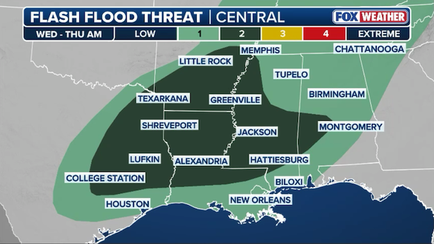
Flash flooding is a concern for millions across the South today as storms "train" over the same areas.
A level 2 out of 4 threat for flash flooding—is in effect today for parts of East Texas, Louisiana, Mississippi, and western Alabama.
The concern here is a phenomenon meteorologists call training. Think of it like a literal train on a track: one storm cell after another moves over the exact same neighborhood. Instead of a quick 20-minute downpour that drains away, you get hours of intense rain that overwhelms ditches and roads.
FOX Weather meteorologists are also seeing signs of backbuilding, where new storms are constantly forming on the tail end of the line, keeping the rain pinned over the same areas for longer than usual.

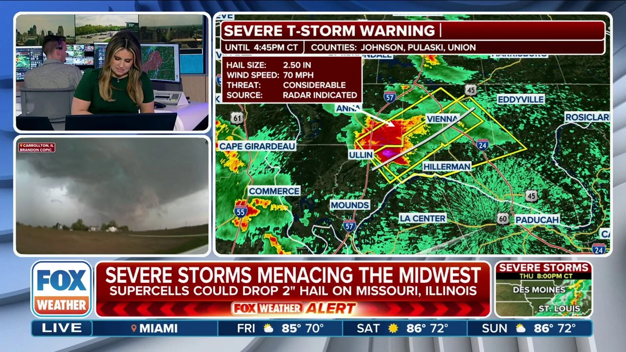
Kankakee, Illinois, resident Krystal Cole joins FOX Weather to discuss the aftermath of large hail—some reaching 6 inches—that damaged her home and busted through the roof during severe storms Tuesday.
The Storm Prediction Center says conditions are becoming favorable for severe weather into the afternoon.
The Storm Prediction Center (SPC) is preparing to issue a Tornado Watch for parts of eastern Ohio, western Pennsylvania, and northern West Virginia as the atmospheric environment destabilizes ahead of a powerful cold front.
This watch is expected to go into effect shortly and will likely cover the afternoon and evening hours, as dangerous storms move into the area.
If you live in cities like Pittsburgh, PA, Wheeling, WV, and Steubenville, OH, you should ensure you have multiple ways to receive warnings as the day goes on.
Kankakee, Illinois Mayor Chris Curtis joins FOX Weather Correspondent Katie Byrne after a life-threatening tornado, accompanied by damaging hail and torrential downpours, ravaged the county.
Significant structural damage has been reported to homes and businesses, and some rescues took place overnight. Curtis says the last 24 hours “have been hectic.”
New York is about to experience a classic case of spring weather whiplash. As a powerful cold front marches east, the tri-state area will transition from a record-setting afternoon into a winter-like reality in less than 24 hours.
The same storm system responsible for the destructive tornadoes in the Midwest is set to pull a dramatic bait-and-switch on New York City.
Today, southwesterly winds are pumping unseasonably warm air into the region, with temperatures expected to soar into the mid-60s—nearly 20 degrees above the seasonal average. This follows Tuesday's record-setting 80°F high temperature, the earliest 80°F ever recorded in New York's Central Park.
However, this spring-like feel will be short-lived as a potent cold front approaches the I-95 corridor tonight, triggering a line of heavy rain and gusty winds.
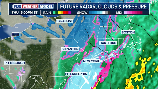
New York is bracing for weather whiplash as the same storm system responsible for severe weather targets the city with snow on Thursday.
By Thursday morning, the atmosphere will undergo a dramatic change. As the front passes, winds will shift sharply to the northwest, ushering in a much colder air.
Temperatures that were in the 60s Wednesday afternoon will plummet into the low 30s by Thursday evening. This rapid cooling will likely cause lingering rain to change over to a period of wet snow late Thursday.
While the warm ground will prevent major accumulations on roads, New Yorkers should prepare for a messy Thursday evening commute and a raw, winter-like finish to the week.
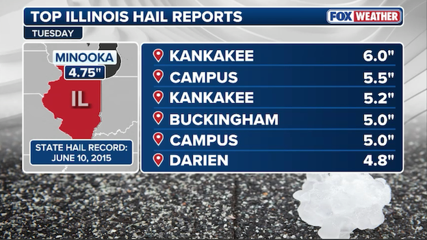
Huge hailstones were measured in Illinois on Tuesday evening as a dangerous supercell thunderstorm tore through the region.
Monster hailstones plummeted Northern Illinois on Tuesday, with several confirmed reports of ice chunks shattering car windshields and denting roofs.
In Kankakee, a staggering 6-inch hailstone was measured—a size comparable to a honeydew melon—which is currently being evaluated as a potential new Illinois state record.
Radar showing severe thunderstorms charging across the Ohio Valley this morning.
The severe storm threat is rapidly expanding eastward this morning as a powerful line of thunderstorms charges through the Ohio Valley, bringing the risk of damaging winds and large hail to Ohio, West Virginia, and Kentucky.
This activity marks the first of two waves expected today, with FOX Weather meteorologists warning that these morning storms are setting the stage for a more intense second round this afternoon.
The Storm Prediction Center says the current Tornado Watch may need to be expanded farther east if the storms hold their strength.
Radar showing the supercell thunderstorm producing a tornado in Texas this morning.
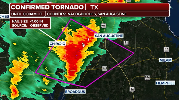
The National Weather Service says it is tracking a tornado near Macune, Texas this morning.
A Tornado Warning is in effect for Nacogdoches and San Augustine Counties until 8:00 a.m. CT.
Recovery efforts following Tuesday’s destructive tornado outbreak have slowed this morning as heavy rain prevents the Indiana State Police (ISP) from deploying drones and aircraft to survey the damage.
ISP Sgt. Glen Fifield confirmed that Governor Mike Braun has been briefed on the situation as the state moves into an "evolving recovery process."
While the most severe destruction remains centered in Newton County, officials expanded the list of impacted areas to include Jasper, Starke, Lake, Porter, and LaPorte counties, with a damage path stretching nearly 50 miles east from the Illinois-Indiana state line.
Newton County Sheriff Shannon Cothran provided a heartbreaking update on the casualties in Lake Village, confirming that the two fatalities were an elderly male and female from the same family. Their names are being withheld pending a formal release from the Newton County Coroner.
While Jasper County reports houses destroyed and significant structural damage, Sgt. Fifield noted there have been no other reported deaths at this time. For those displaced, an emergency shelter is fully operational at North Newton Junior High School in partnership with the American Red Cross.
The severe weather threat that devastated the Midwest last night has evolved into a complex, multi-stage event for the eastern half of the country.
Unlike a single line of storms, meteorologists are tracking two distinct waves of energy that will keep the Ohio Valley and Mid-Atlantic on high alert through the late evening hours. A powerful cold front is acting as the primary trigger, but record-warm air surging ahead of it is providing the fuel for widespread instability.
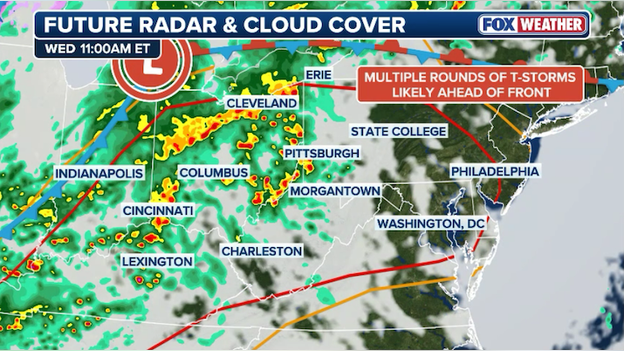
Dangerous thunderstorms are forecast to slam the Ohio Valley and Mid-Atlantic through the evening.
The first wave (Late morning – early afternoon)
A surge of energy ahead of the front is already sparking scattered clusters of thunderstorms across Illinois, Indiana, and Ohio. While these storms may appear disorganized on radar, the high-altitude winds are strong enough to support sudden, damaging gusts and large hail.
This initial round will primarily impact the midday commute and lunch hour for cities like Columbus, Charleston, and Pittsburgh.
The second wave (late afternoon – tonight)
The more potent threat arrives later today as the actual cold front slams into the volatile air mass. This second round is expected to form into a fully-fledged squall line, pushing from the Great Lakes down to the Gulf Coast.
As this line crosses the Appalachians into the Mid-Atlantic, the risk shifts to intense straight-line winds and isolated tornadoes.
People in Philadelphia, Baltimore, and Washington, D.C. should prepare for the most significant weather to arrive during the evening hours, with the potential for flash flooding in urban areas where 1–2 inches of rain could fall in a very short window.
Millions of Americans across the South are on high alert today for the threat of severe weather, including tornadoes.
The FOX Forecast Center is tracking a disturbance currently moving through West Texas that is expected to undergo a dramatic energy shift this afternoon. Meteorologists call this becoming negatively tilted. Think of it like a spinning top that suddenly gains a second burst of speed; as the storm system "leans" back toward the northwest, it acts like a giant vacuum, pulling warm, moist air off the Gulf and forcing it upward with incredible force.
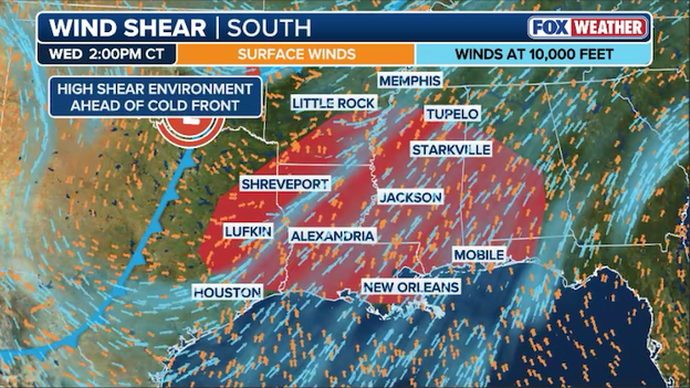
Wind shear ahead of an approaching cold front will help produce supercell thunderstorms in the South.
This setup is particularly concerning because an 80 mph jet streak is screaming overhead. This high-speed "river of air" provides the spin needed for storms to rotate.
As this system tracks along the Sabine River Valley and across Louisiana and Mississippi tonight, forecasters expect a powerful squall line to form.
The main threats will be damaging straight-line winds, but because the atmosphere is so "twisted" by that jet streak, tornadoes are a very real possibility—especially if individual storm cells can break away from the main line or form out ahead of it.
FOX Weather meteorologists are closely monitoring the overall forecast trends this morning as an upgrade in the threat level is possible later today.
According to PowerOutage.com, thousands of residents across the Midwest and South are waking up in the dark this morning as utility crews scramble to repair massive infrastructure damage left behind by Tuesday's deadly tornado outbreak.
The hardest-hit areas are concentrated in Northwest Indiana and Northern Illinois, where high-tension utility poles were snapped like toothpicks and hundreds of individual lines were brought down by falling trees and record-breaking hail.
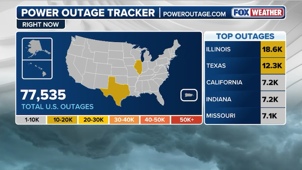
Latest power outage tracker showing significant outages from Illinois to Texas. (PowerOutage.com)
In Kankakee County, nearly 10% of the community remains without electricity as ComEd and local cooperatives prioritize clearing live wires from major roads like US Route 45.
Farther east in Newton County, Indiana where at least two fatalities have been confirmed, the darkness is complicating secondary search and rescue operations.
As severe storms charge toward the East Coast, power outage numbers are expected to fluctuate throughout the day, particularly as high wind gusts hit the saturated soil and weakened trees of the Ohio Valley.
Lake Township Fire Chief Rob Churchill described a scene of "total devastation" in Lake Village, Indiana, as crews worked through complete darkness Tuesday night to reach residents trapped in their homes.
Churchill noted that the situation was compounded by loose livestock wandering through debris-filled streets and a loss of power that made navigation nearly impossible.
Despite the structural destruction, including houses that completely collapsed, Churchill credited a multi-day warning period for saving lives.
This was reported days before. The National Weather Service, all the Chicago stations (TV), all the weather people were reporting this. I think if it wasn't for that, I really truly think that our injuries and fatalities would be considerably higher — I think people were well warned.
The fire department’s proactive stance played a critical role in their response. By coordinating directly with the National Weather Service and emergency management, the department positioned spotters in Illinois the moment the tornado was confirmed in Kankakee.
This early intelligence allowed Lake Township crews to be ready and in position before the vicious twister even crossed the state line into Indiana.
National Weather Service meteorologists are working to verify a massive 6-inch hailstone recovered during Tuesday night’s violent supercell.
If officially confirmed, this monster stone would shatter the current Illinois state record of 4.75 inches, set in Minooka back in 2015.
To put that size into perspective, a 6-inch hailstone is roughly the size of a honeydew melon or a large grapefruit, capable of falling at speeds exceeding 100 mph.
The NWS survey team will assess the stone’s dimensions to ensure it meets the rigorous criteria for the state record books.
The National Weather Service is deploying survey teams this morning to officially rate the intensity of the tornadoes that tore through Kankakee, Newton, and Jasper counties in Illinois and Indiana.
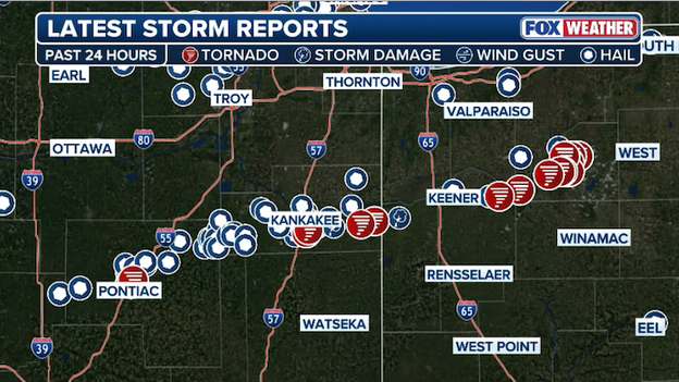
Storm reports showing the path of the destructive supercell thunderstorm that charged through Illinois and Indiana.
In addition to assessing structural damage in hard-hit areas like Lake Village, experts will also evaluate the historically large 5.2-inch hail reported near Kankakee to determine if it sets a new state record for Illinois.
The American Red Cross has mobilized in the wake of Tuesday's destructive tornadoes, opening an emergency shelter at North Newton High School to provide food, water, and support to displaced families.
Teams are also working alongside local officials in Kankakee, Illinois to ensure that residents in hard-hit communities like Aroma Park have access to essential recovery resources and medical supplies.
The sheer scale of the destruction in Newton County is becoming clear this morning as utility crews report hundreds of downed power lines and at least 70 snapped utility poles following the violent tornado.
These severe infrastructure hits have left thousands in the dark and created "death traps" on local roadways, complicating the ongoing search and rescue efforts in the hardest-hit areas.
The Lake Township Fire Department confirms two people were killed and several others were injured by the intense tornado that ripped through Lake Village, Indiana on Tuesday night.
Newton County Sheriff Shannon Cothran says the two fatalities were an elderly male and female from the same family.
Lori Postma, Public Information Officer for the Lake Township Fire Department, says firefighters located several "very injured" people in the immediate aftermath. Fewer than ten people were officially transported to area hospitals, with some residents choosing to self-deploy for medical care.
This morning, officials noted that no one is currently reported missing.
The devastation also hit home for the first responders themselves; Postma revealed that four firefighters had their homes severely damaged or destroyed while they were out saving others.
Search and rescue operations have been tireless, with a primary search of all damaged areas completed by 4:00 a.m. CT. Indiana Task Force 1 is expected on the ground today to perform a secondary, more technical survey of the debris fields to ensure no survivors were overlooked.
Amidst the heartbreak, Postma highlighted "miraculous" stories of survival, including one man who walked away unscathed after massive trees crushed his vehicle.
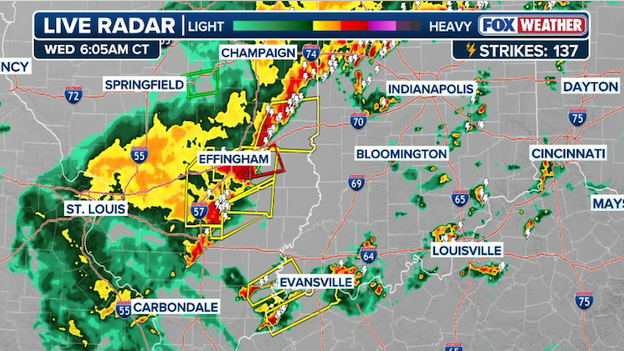
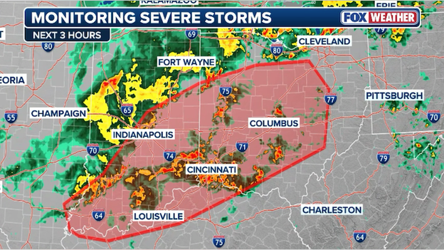
Radar showing a line of severe thunderstorms roaring across parts of the Ohio Valley right now.
A line of severe thunderstorms is currently charging through the Ohio Valley this morning, marking the first of two expected waves of severe weather today.
Residents across Illinois, Indiana, and Kentucky are experiencing frequent lightning, torrential downpours, and wind gusts up to 60 mph as the storms track eastward.
FOX Weather Meteorologist Ari Sarsalari breaks down the dangerous severe storm that ripped through the Kankakee, Illinois area, spawning numerous tornadoes that caused significant damage in impact areas, triggering the first Tornado Emergency of the year.
A Tornado Warning has been issued for Cumberland, Effingham and Jasper counties in Illinois through 06:30 a.m. CT.
This includes portions of the Interstate 70 and Interstate 57 corridors.
A Tornado Watch has been issued for parts of the Ohio Valley until noon ET.
The National Weather Service has issued a Tornado Watch until 12:00 p.m. ET for southeastern Illinois, central and southern Indiana, the Outer Bluegrass region of Kentucky and western Ohio.
Thunderstorms are expected to increase over the next few hours, and with warm, moist, and unstable air and strong wind shear in place across much of the Ohio Valley, severe thunderstorms capable of producing a few tornadoes, damaging winds, and large hail are expected.
Drone footage captures the immediate aftermath of a destructive tornado that ripped through Kankakee, Illinois, demolishing several structures on its path through the northeastern Illinois city.
The footage reveals the staggering scope of destruction left behind after a powerful tornado that tore through Kankakee before crossing into Indiana.
From above, entire rooftops are peeled back or torn away, walls lie collapsed and debris is strewn in every direction — an area left flattened in the path of a dangerous tornado.
Following last night’s destructive tornado outbreak in the Midwest, the massive storm system responsible for it all is shifting east today, placing over 100 million people under a severe weather threat.
The Storm Prediction Center has outlined an expansive risk zone that sweeps from the Gulf Coast through the Ohio Valley and into the Mid-Atlantic.
Wednesday's severe storm threat extends from the Mid-Atlantic and Ohio Valley down to the Gulf Coast.
While damaging straight-line winds are the primary concern as the cold front marches east, the atmosphere remains volatile enough to support isolated tornadoes and large hail, particularly in parts of Ohio, Pennsylvania, and West Virginia this afternoon.
Farther south, the threat extends deep into the Lower Mississippi Valley, where moisture from a record-warm Gulf of America is fueling a renewed round of intense thunderstorm development.
Residents from East Texas and Louisiana through Mississippi and Alabama should remain weather-aware for quick-developing cells capable of producing brief twisters and torrential rain.
As the line of storms pushes toward the Eastern Seaboard tonight, the risk of flash flooding will also increase, especially in urban corridors from Pittsburgh to Washington, D.C., where heavy downpours may overwhelm drainage systems already saturated by early spring rain.
Kankakee County officials have officially filed an Emergency Declaration with the State of Illinois following the destructive tornado that tore through the region Tuesday night.
In a joint statement released by Sheriff Mike Downey, County Board Chairman Matthew Alexander-Hildebrand, and Mayor Chris Curtis, the county confirmed that the Emergency Operations Center has been fully activated to coordinate the response.
I want to remind area residents to check on their neighbors and loved ones but to avoid unnecessary travel, if at all possible.
Right now, emergency personnel are currently on the ground performing damage assessments and search and rescue operations. And fortunately, officials report there have been no reported injuries or loss of life as of Wednesday morning.
Residents are being urged to avoid all unnecessary travel as heavy debris, downed power lines, and fallen trees have made many local roads impassable and hazardous.
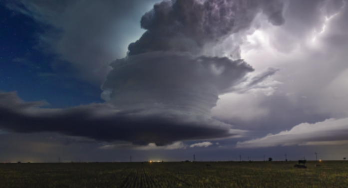
Dramatic video from FOX Weather Storm Tracker Brandon Copic captured the raw power of a violent tornado as it tore through the Kankakee, Illinois, area on Tuesday evening.
The intense video shows the massive twister illuminated by frequent lightning strikes and power flashes as it tore through the south side of the city.
As we shift our focus to the rising threat on the East Coast, we are continuing to process the sheer scale of the destruction left behind in the Heartland.
Last night’s coverage was marked by the first Tornado Emergency of 2026, as a violent long-track twister tore through Kankakee, Illinois, and Lake Village, Indiana.
Our team at FOX Weather provided nonstop, minute-by-minute analysis as the storms exploded:
You’ve reached the beginning of this live coverage.