Severe storm threat moves to Ohio and Tennessee valleys during second half of weekend
Several tornadoes were spotted Saturday in northwest Minnesota. The main threats from storms on Sunday will be hail and gusty winds.
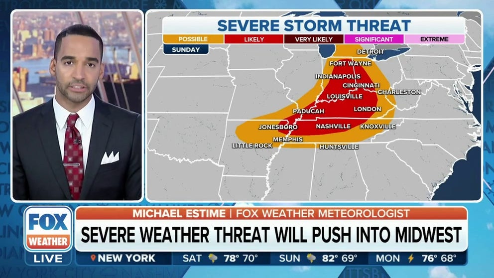
Tracking severe storm threat on Sunday
FOX Weather meteorologist Michael Estime is tracking the threat for storms in the Tennessee and Ohio valleys on Sunday. Storms will be capable of producing hail and damaging winds.
Thunderstorms are expected to continue their eastward march into the Great Lakes and Ohio and Tennessee valleys Sunday, producing additional threats for severe weather.
The FOX Forecast Center said a frontal boundary will be the focus of the showers and thunderstorms during the afternoon and evening. Hail appears to be the largest threat, but an isolated tornado and damaging wind gusts cannot be ruled out.
The storm system triggered several Tornado Warnings in northwest Minnesota on Saturday and gusty winds and hail was reported throughout Iowa.
Near the North Dakota-Minnesota border, storm chasers spotted a multi-vortex tornado near the town of Ada.
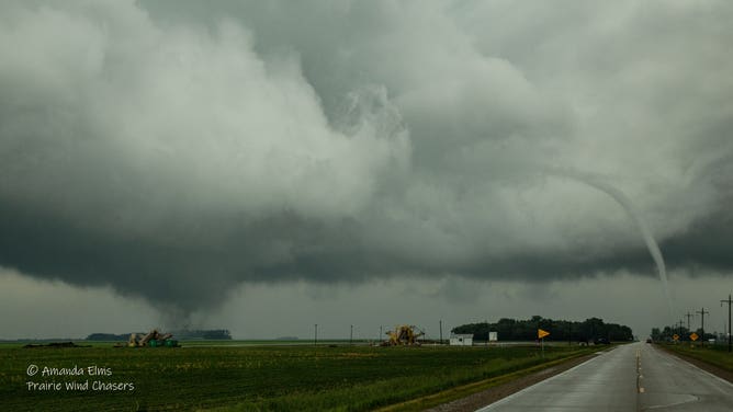
Multi-vortex tornado spotted near Ada, Minnesota.
(Amanda Elms / FOX Weather)
The tornado was one of at least a dozen initial reports of twisters in Minnesota.
After the storms rolled through, more than 35,000 electric outages were reported by PowerOutage.us, with many of the issues reported around the Twin Cities.
IN A FLASH: LIGHTNING CHASER SHARES HOW TO CAPTURE NATURE'S FURY ON CAMERA

(FOX Weather)
Sunday's severe weather impact zone
The frontal boundary that has impacted the northern tier for days is expected to push into the Ohio and Tennessee valleys Sunday.
Sunday's thunderstorm threat zone stretches from Michigan to the Gulf Coast, with parts of Ohio, Kentucky and Tennessee under the highest risk of severe storms.
The Storm Prediction Center has given this area a Level 3 out of 5 on its thunderstorm category risk scale.
Included in this zone are communities around Cincinnati in Ohio, Nashville in Tennessee and Lexington in Kentucky.
Similar to Saturday, large hail and damaging winds appear to be the main threats, but a few tornadoes can't be ruled out.
"It’s kind of a multidimensional threat with hail in Elizabethtown, down toward Bowling Green, Kentucky, back toward Paducah," said FOX Weather meteorologist Michael Estime.

(FOX Weather)
Monday's forecast
A lingering severe weather threat will push into the Carolinas and coastal mid-Atlantic states Monday.
The frontal boundary will slowly march toward the Eastern Seaboard, where showers and thunderstorms will be possible from the Northeast, through the Carolinas and into Georgia.
The mid-Atlantic and the Carolinas are expected to be in the target zone where storms could be strong to severe with gusty winds and hail.
Flooding concerns are expected to be minimal, with forecast models showing most communities picking up less than an inch of rain.
Rain chances are expected to diminish on Tuesday with the front moving offshore.

(FOX Weather)
10 injured as rounds of storms impact central US Friday
During a round of early storms in Texas, a Fort Worth police cadet and two firefighters were hit by a lightning strike at the department’s training facility.
FOX 4 Dallas reported the strike happened in the morning as the group was running outside at the facility as a storm arrived at the Fort Worth Police Department’s headquarters. Two firefighters were treated at the scene for minor injuries while a police cadet was taken to a local hospital to be checked out.
FORT WORTH POLICE CADET STRUCK BY LIGHTNING WHILE TRAINING
In northeastern Wyoming, seven people were injured when a tornado struck the North Antelope Rochelle Mine, according to Leslie Perkins with Wyoming's Campbell County. An eighth person refused medical treatment, Perkins said.
Mine officials were to release information later Saturday on the extent of any tornado damage to the facility.
In southwest Wyoming, a tornado formed near the town of Little America. Video from a local resident showed the rope-like twister on the ground for several minutes before lifting.
There were no immediate reports of damage from the rural region of the state.

Caught on video: Rope tornado moves through southwest Wyoming
Danny Patterson took video on Friday afternoon of a rope tornado moving through Little America, Wyoming. The area was under a Tornado Warning at the time.
At least one tornado was also spotted in southeast Idaho near the towns of Soda Springs and Grace.
The local NWS office did not report any damage associated with the twister.
Egg to tennis-ball-sized hail was reported in southeastern Wyoming on Friday evening. The hail was associated with a supercell that produced a tornado over rural parts of Goshen County.

Egg to tennis ball-sized hail fell around Slater, north of Cheyenne on Friday, June 23.
(Gavin H./ @Vaclaurus / FOX Weather)
A Tornado Emergency was issued for communities in western Nebraska which included the towns of Scottsbluff and Gering.
The local National Weather Service office said a large and dangerous tornado was spotted around 8 p.m. local time and was moving eastward.
According to PowerOutage.us, electricity outages were minimal in the warned area after the tornado moved through.

Tornado spotted in western Nebraska
In this video, a driver speeds away from a tornado in reverse in Scottsdale, Nebraska. June 23, 2023. (Courtesy: Christopher Vohland / Facebook)