Atlanta, Washington among 44 million in eastern US seeing severe storms packing damaging winds
NOAA’s Storm Prediction Center placed areas of northern Alabama and North Georgia northward through western New England in a Level 1 out of 5 risk on its 5-point severe thunderstorm risk scale.
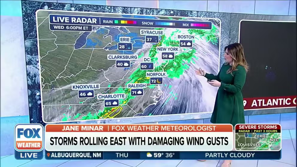
Severe storm threat with damaging wind gusts shifts east
Many Americans in the Northeast will experience a rainy night as storms and powerful winds push into the area. Feb. 28, 2024.
WASHINGTON – About 44 million people across the eastern U.S., including Atlanta, Baltimore, Washington and Charlotte, North Carolina, saw severe weather and damaging wind gusts on Wednesday after a powerful cold front barreled across the Midwest and Ohio Valley Tuesday and into early Wednesday, leading to dozens of Tornado Warnings and reports of large hail.
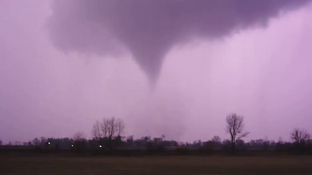
Watch: Likely tornado illuminated by lightning near Hinckley, Illinois
Video recorded near Hinckley, Illinois, shows what appears to be a tornado being illuminated by lightning during severe weather on Tuesday night.
The severe weather threat Wednesday stretched from the western slopes of the Appalachians to the Carolinas, mid-Atlantic and Northeast as the powerful cold front advanced eastward.
NOAA’s Storm Prediction Center (SPC) placed areas of northern Alabama and North Georgia, including Atlanta, northward through western New England in a Level 1 out of 5 risk on its 5-point severe thunderstorm risk scale.

(FOX Weather)
This included cities such as Knoxville in Tennessee, Charlotte and Raleigh in North Carolina, Roanoke and Richmond in Virginia, Washington, Baltimore, Pittsburgh and Scranton in Pennsylvania, Syracuse and Albany in New York and Burlington in Vermont.
WATCH VS. WARNING: HERE ARE THE DIFFERENCES BETWEEN THESE WEATHER TERMS THAT COULD SAVE YOUR LIFE

(FOX Weather)
Heavy rain were more of a concern than the severe weather threat on Wednesday.
"There’s a little bit of a dry slot, and then it’s going to turn into very heavy rain later this morning and into the afternoon hours," FOX Weather Meteorologist Bob Van Dillen said. "It’s going to stretch into major cities."

(FOX Weather)
Flood Watches had been posted by the National Weather Service for portions of northern New York, Vermont, New Hampshire and most of Maine.
"A lot of that could be rain on top of snowpack to be honest," FOX Weather Meteorologist Britta Merwin said. "We’re still eroding the snowpack across the north, and this rain is going to fall on top of that."
7 FACTS YOU SHOULD KNOW ABOUT FLASH FLOODS

(FOX Weather)
"If you’re trying to travel today, even if you’re not getting rain, the wind is going to be a huge factor," Van Dillen continued.
Wind Advisories for gusts up to 50 mph are in effect across the Northeast and New England, and High Wind Warnings have been issued for areas of the eastern Great Lakes in New York state. Northern coastal Maine, as well as Cape Cod in Massachusetts, has also been placed under a High Wind Warning in anticipation of wind gusts up to 60 mph.
DAMAGE REPORTED AFTER TORNADO WARNINGS WAIL ACROSS OHIO VALLEY AMID ONGOING SEVERE WEATHER THREAT
Severe thunderstorms, tornadoes tear across Midwest, Ohio Valley
![Destroyed building in Grand Blanc, Michigan. Feb. 28, 2024.]() Image 1 of 10
Image 1 of 10Destroyed building in Grand Blanc, Michigan. Feb. 28, 2024. (Grand Blanc Township Fire Department / Facebook)
![This image shows a vehicle damaged after a tree fell on top of it during severe weather in Calhoun County, Michigan, on Wednesday, Feb. 28, 2024.]() Image 2 of 10
Image 2 of 10This image shows a vehicle damaged after a tree fell on top of it during severe weather in Calhoun County, Michigan, on Wednesday, Feb. 28, 2024. (Calhoun County Sheriff's Office, Michigan/Facebook)
![Snapped tree branches are strewn across the pavement in Kane County, Illinois. Feb. 28, 2024.]() Image 3 of 10
Image 3 of 10Snapped tree branches are strewn across the pavement in Kane County, Illinois. Feb. 28, 2024. (Kane County Emergency Management / Facebook)
![This image shows damage caused by severe weather in Calhoun County, Michigan, on Wednesday, Feb. 28, 2024.]() Image 4 of 10
Image 4 of 10This image shows damage caused by severe weather in Calhoun County, Michigan, on Wednesday, Feb. 28, 2024. (Calhoun County Sheriff's Office, Michigan/Facebook)
![This image shows the damage left behind when severe weather tore through Calhoun County in Michigan on Wednesday, Feb. 28, 2024.]() Image 5 of 10
Image 5 of 10This image shows the damage left behind when severe weather tore through Calhoun County in Michigan on Wednesday, Feb. 28, 2024. (Calhoun County Sheriff's Office, Michigan/Facebook)
![This image shows a large tree that was uprooted during severe weather in Calhoun County, Michigan, on Wednesday, Feb. 28, 2024.]() Image 6 of 10
Image 6 of 10This image shows a large tree that was uprooted during severe weather in Calhoun County, Michigan, on Wednesday, Feb. 28, 2024. (Calhoun County Sheriff's Office, Michigan/Facebook)
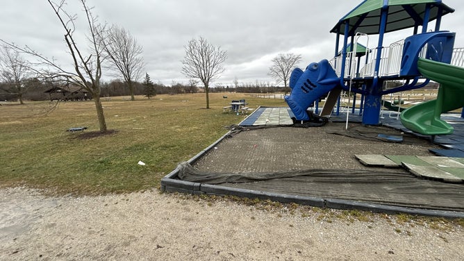
![Storm damage on a playground at Creasey Bicentennial Park. Feb. 28, 2024.]() Image 7 of 10
Image 7 of 10Storm damage on a playground at Creasey Bicentennial Park. Feb. 28, 2024. (Grand Blanc Township Fire Department / Facebook)
![Site of missing pavilion at Creasey Bicentennial Park. Debris is in the lake. Feb. 28, 2024.]() Image 8 of 10
Image 8 of 10Site of missing pavilion at Creasey Bicentennial Park. Debris is in the lake. Feb. 28, 2024. (Grand Blanc Township Fire Department / Facebook)
![Destroyed buildings in Grand Blanc, Michigan. Feb. 28, 2024.]() Image 9 of 10
Image 9 of 10Destroyed buildings in Grand Blanc, Michigan. Feb. 28, 2024. (Grand Blanc Township Fire Department / Facebook)
![Destroyed building in Grand Blanc, Michigan. Feb. 28, 2024.]() Image 10 of 10
Image 10 of 10Destroyed building in Grand Blanc, Michigan. Feb. 28, 2024. (Grand Blanc Township Fire Department / Facebook)


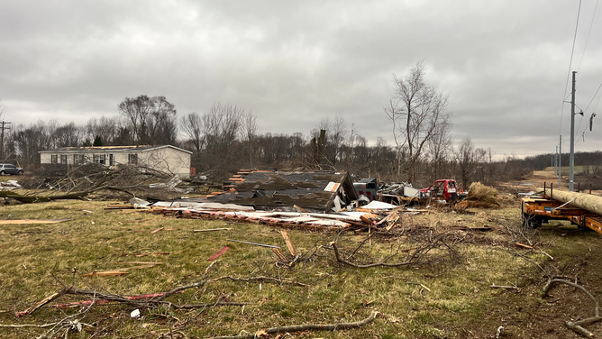
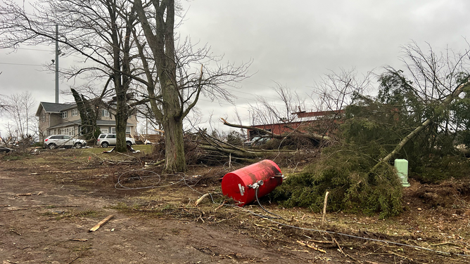


So far, there haven't been any reports of injuries from the destructive thunderstorms and likely tornadoes that ripped across parts of Illinois, Ohio and Michigan.
In Michigan's Henry County, the NWS confirmed that a tornado that ripped through the area on Tuesday was an EF-1. In Calhoun County, the NWS confirmed that the storm that swept through the area produced an EF-2 tornado.
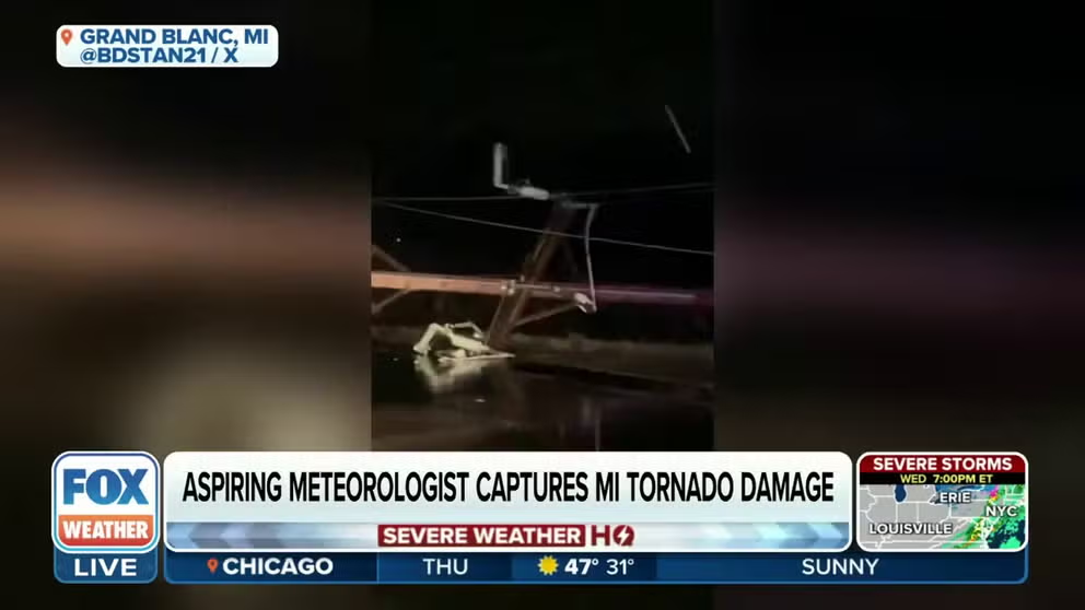
Aspiring meteorologist headed out to watch EF-2 tornado one mile away
Aspiring meteorologist, Ben Stanley, calls himself a "weather nerd" and couldn't resist heading outside when he heard the tornado warning sirens. The EF-2 tornado travelled just a mile away. He shares his video from Grand Blanc, Michigan.
A storm spotter near Springfield, Ohio, reported a tornado that damaged several homes southeast of the town.
In the Dayton area, strong thunderstorms knocked a large tree into a home near Huber Heights, and thunderstorms brought wind gusts to 60 mph near Springfield and 69 mph in London, Ohio.
Just east of Dayton, a possible tornado blew out glass at a shopping center, with likely tornado-caused tree damage nearby, according to National Weather Service storm reports.

Watch: Nighttime video shows tornado sweeping across landscape near Gary, Indiana
Dramatic video recorded near Gary, Indiana, shows a tornado sweeping across the landscape during severe weather in the Midwest and Ohio Valley Tuesday night.
Tornado Warnings were issued in Columbus, Ohio, before dawn Wednesday as the line of thunderstorms moved through, and Columbus’ John Glenn Airport urged travelers in the terminal to seek shelter while the warning was in effect.
Kentucky has dealt with more of a damaging-wind and large hail threat from severe thunderstorms. Wind gusts there reached 50-60 mph around and north of Lexington and Frankfort, with radar-indicated hail exceeding 1 inch in diameter.

Watch: Video shows tornado near Gary, Indiana
A video recorded during severe weather in Indiana on Tuesday night shows a tornado spinning near Gary.