Winter storm delivering snow, ice across Northeast in its final chapter Friday
An icy wintry mix will cause slick travel conditions on Friday from the interior Northeast to the I-95 corridor, including Boston and the New York City tri-state area
Massive winter storm could cause some icing along I-95 corridor
This massive winter storm could cause some icing along the I-95 corridor on Friday.
FOX Weather is live with the Weather Wire covering live updates on the massive winter storm impacting more than 100 million Americans across the country. Click the FOX Weather Wire for live updates.
The major winter storm will conclude its 2,000-plus-mile journey across the United States on Friday as it delivers snow, sleet and freezing rain to the Northeast, creating icy roads in Boston and the New York City tri-state area.
This storm got underway Tuesday night and Wednesday when it dumped heavy snow in the Rockies and Midwest, then produced crippling amounts of ice that damaged trees and knocked out power from Central Texas to the Ohio Valley on Thursday. Its warm side even spawned a tornado in Alabama on Thursday, which killed one person and injured several others.
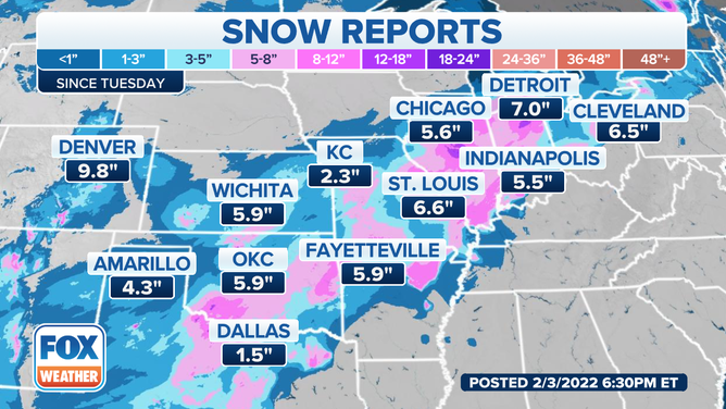
Snow reports in major cities along the winter storm's path.
(FOX Weather)
As much as three-quarters of an inch of ice accretion was reported in Central Texas on Thursday, while a half-inch of ice was measured in several other locations from Central and North Texas to Arkansas and West Tennessee. The storm even brought ice as far south as Corpus Christi, Texas.
According to PowerOutage.us, more than 400,000 customers from Texas to New York were without power in the winter storm's wake as of 9:30 a.m. Eastern time Friday morning. Tennessee, Ohio and New York had the most widespread outages.
7 WAYS TO STAY SAFE WHILE USING A GENERATOR
Winter Storm Warnings remain in effect on Friday from northern and eastern Ohio to western West Virginia, northern and western Pennsylvania, upstate New York, northern Massachusetts, Vermont, New Hampshire and Maine. This includes Syracuse and Albany in New York, Burlington and Montpelier in Vermont and Portland and Bangor in Maine.
Winter Weather Advisories are posted from the Ohio Valley to much of Pennsylvania, northern New Jersey, southeastern New York, Connecticut, Rhode Island and southern and eastern Massachusetts. This includes New York City, Boston and Providence, Rhode Island.
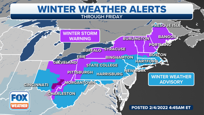
Winter Storm Warnings and Winter Weather Advisories remain in effect across Northeast on Friday, Feb. 4, 2022.
(FOX Weather)
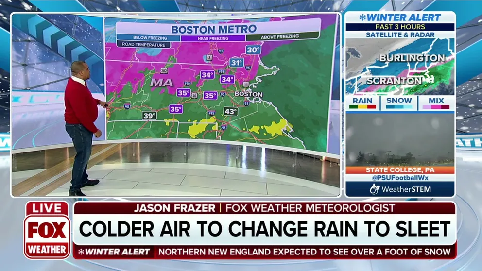
As this storm's cold front slowly slides southeastward through the Northeast on Friday, any ongoing rain along the Interstate 95 corridor will change over to a period of freezing rain, sleet and snow from Boston to the New York City tri-state area.
WEATHER WIRE: WINTER STORM'S FINAL CHAPTER UNDERWAY IN NORTHEAST AS SNOW, ICE CONTINUE TO CRAWL EAST
Slick travel conditions are expected in this region, especially in central and southern New England, where a flash freeze will occur as temperatures rapidly fall into the 20s Friday morning into early Friday afternoon.
In New York City, the temperature fell from 56 to 38 degrees in one hour between 7 a.m. and 8 a.m. Friday morning as the cold front moved across the Big Apple.
Snow will also continue Friday in northern New England, upstate New York, northern and western Pennsylvania and portions of the upper Ohio Valley. The heaviest snow is expected to pile up in parts of Maine.
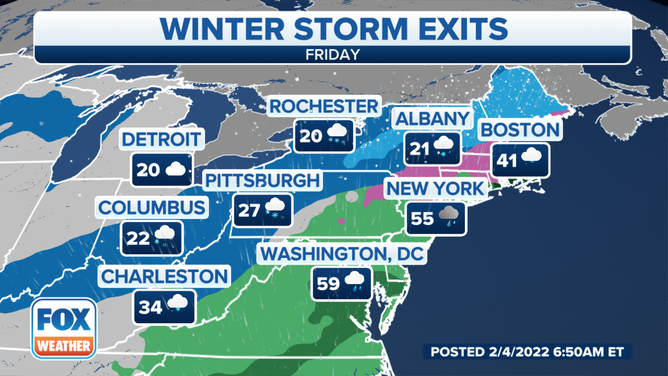
Forecast for Friday, Feb. 4, 2022.
(FOX Weather)
This storm will finally exit off the Northeast coast Friday night, with another blast of frigid air following in its wake for the weekend.
BITTERLY COLD TEMPERATURES, DANGEROUS WIND CHILLS INVADING CENTRAL, EASTERN U.S. BEHIND WINTER STORM
At least 6 inches of additional snow – on top of what has already fallen – is likely in portions of Maine before it tapers off overnight into early Saturday.
An additional dusting to a couple of inches is possible in other locations across the interior Northeast through Friday.
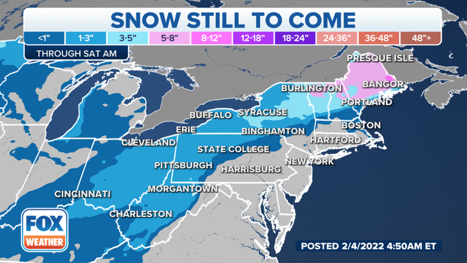
Additional snowfall through early Saturday, Feb. 5, 2022.
(FOX Weather)
Freezing rain could lead to additional light icing from central and southern New England to southeastern New York, including Boston and the New York City tri-state area, and into portions of northern New Jersey and Pennsylvania.
The precipitation should stay in the form of rain farther south along Interstate 95 from Philadelphia to Baltimore and Washington, but icy spots are possible in the northwestern suburbs of those metro areas.
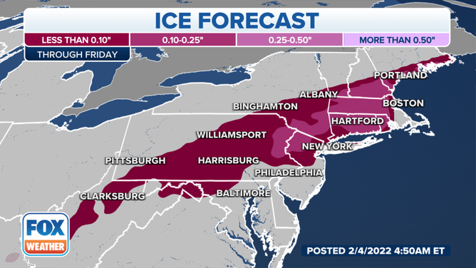
Ice forecast through Friday, Feb. 4, 2022.
(FOX Weather)
Winter storm recap
Snow totals
This sprawling winter storm got underway Tuesday night and Wednesday in the Rockies and Midwest.
The highest snowfall total was recorded in New Mexico, where Taos Ski Valley measured 37 inches.
Between 6 and 11 inches of snow fell in the Denver metro area, while up to 22 inches was measured in the higher elevations south and southwest of Colorado Springs, Colorado.
COLORADO SPRINGS BLANKETED BY NEARLY 2 FEET OF SNOW
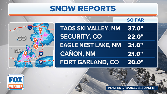
Top snowfall reports in the Rockies.
(FOX Weather)
At least 6 inches of snow was reported over a broad area from central Missouri into central and northern Illinois, northern Indiana and southern Lower Michigan, including portions of Chicagoland.
As of Friday morning, the top snowfall total east of the Rockies was 15.2 inches near Columbia City, Indiana.
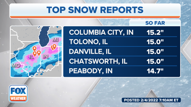
Top snowfall reports east of the Rockies as of 7:10 a.m. Eastern time Friday, Feb. 4, 2022.
(FOX Weather)
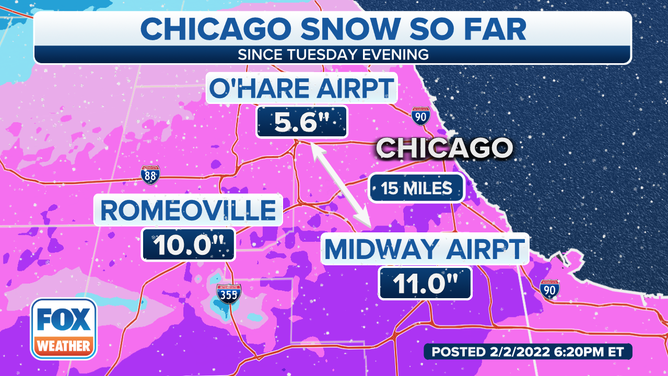
There was a sharp gradient in snow totals across Chicagoland on Wednesday, as illustrated in the map below.
O'Hare Airport picked up 5.6 inches, but just 15 miles away, 11 inches was measured at Midway Airport.
Snow reports from Chicagoland.
(FOX Weather)
In Michigan, Lansing reported its all-time snowiest February day on Wednesday when 13.3 inches piled up. The previous calendar-day record for February was 13 inches, which had stood since Feb. 28, 1900, according to the National Weather Service. It was also Lansing's sixth-snowiest day of any month and the city's snowiest day since Dec. 11, 2000.
Ice totals
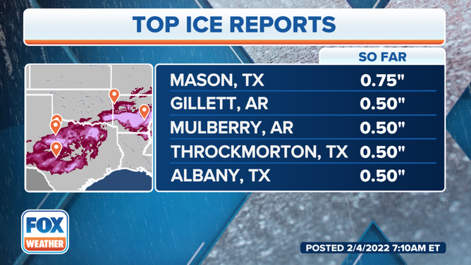
Three-quarters of an inch of ice accretion was reported in Mason, Texas, after several hours of freezing rain had fallen.
Numerous locations from Texas to Arkansas and West Tennessee received at least a half-inch of ice.
One-quarter to one-third of an inch of ice accretion was reported in the Memphis, Tennessee, metro area, where freezing rain had downed trees and knocked out power to more than 120,000 people as of Thursday evening.
HOW MUCH ICE IS NEEDED TO KNOCK OUT POWER, DAMAGE TREES?
Top ice reports as of 7:10 a.m. Eastern time Friday, Feb. 4, 2022.
(FOX Weather)
The Cincinnati, Ohio, metro area saw up to one-third of an inch of ice on Thursday, while up to one-tenth of an inch of ice was measured in Pittsburgh.
In Little Rock, Arkansas, up to 1.5 inches of sleet was recorded on Thursday, along with nearly one-quarter inch of ice near the Oklahoma border in Fort Smith, Arkansas.
Up to three-tenths of an inch of ice was reported in Altamont, Illinois, from freezing rain on Wednesday afternoon.
One-quarter inch of ice accretion was measured in Preston, Missouri, while other parts of Missouri and southern Illinois recorded 0.15 to 0.20 inches of ice.