Invest 95E likely to soon become Tropical Depression 6-E in Eastern Pacific on way to Tropical Storm Flossie
The area to watch has been designated as Invest 95E by the NHC. An invest is a naming conversion used to identify areas forecasters are investigating for possible tropical development into a tropical depression or tropical storm within the next seven days.
Invest 95E in East Pacific forecast to become Tropical Depression 6-E by late weekend
The Eastern Pacific is on track for another tropical depression to form as Invest 95E development odds continue to grow. Forecast models predict Tropical Storm Flossie will form out of this system by late next week.
The National Hurricane Center (NHC) is continuing to monitor the development of an area of low pressure in the Eastern Pacific that's expected to become at least a tropical depression this weekend, on its way to possibly eventually becoming Tropical Storm Flossie.
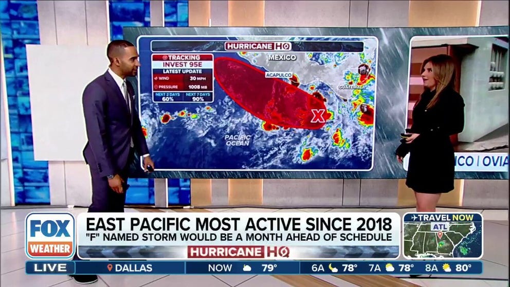
The area to watch for now has been designated as Invest 95E. An invest is a naming convention used to identify areas forecasters are investigating for possible tropical development into a tropical depression or tropical storm within the next seven days.

(FOX Weather)
The NHC said that showers and thunderstorms associated with Invest 95E a few hundred miles south-southwest of the coast of Guatemala are currently poorly organized, but the system is expected to encounter conditions more conducive to development in a few days.
On the current forecast path, the system would become designated Tropical Depression Six-E by Sunday as it moves slowly west-northwest off the coast of southern Mexico.
The NHC is giving the system an 80% chance of developing over the next two days, and a near certain chance of reaching the threshold over the next seven days. Forecast models indicate the storm will eventually strengthen further and, once its peak winds reach 40 mph, become Tropical Storm Flossie.
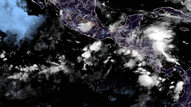
This satellite image shows Invest 95E spinning in the Eastern Pacific off the southern coast of Mexico on June 26, 2025.
(NOAA)
It is unclear if this system will have any direct impacts on Mexico before dissipating.
Heavy rainfall is expected in portions of the southwestern Mexico coast into early next week. Some areas along the immediate coastline could see up to 3-5 inches of rain, according to the FOX Forecast Center.
DOWNLOAD THE FREE FOX WEATHER APP

(FOX Weather)
It's been an active start to hurricane season in the Eastern Pacific Ocean. Last week, Hurricane Erick roared ashore along Mexico's southwestern coast as a strong Category 3 storm, leaving a baby boy dead and causing widespread power outages.
A large pocket of warm water off the coast of Central America and southwestern Mexico has been conducive for development. This warm water helped Hurricane Erick undergo rapid intensification before it made landfall last week.
HOW ARE HURRICANES RATED? THE SAFFIR-SIMPSON HURRICANE WIND SCALE EXPLAINED

(FOX Weather)
According to the NHC, rapid intensification occurs when a tropical cyclone's maximum sustained winds increase by at least 35 mph in a 24-hour period.
Hurricane Barbara was the first hurricane to form in the basin on June 9.
The Eastern Pacific hurricane season runs from May 15 to Nov. 30.