Deadly ice storm brings treacherous driving conditions, power outages as it slides across the South
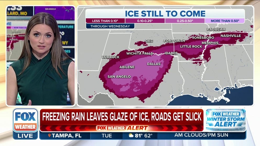
Overall, the forecast calls for upward of a quarter- to half-inch of ice to accrete starting along the I-20 corridor in West Texas, stretching eastward toward I-35, and eventually into parts of southeastern Oklahoma and southern Arkansas. A second area of ice upward of a quarter-inch is also increasingly likely across other parts of Arkansas and into West Tennessee.
Dangerous ice storms creating treacherous travel across Texas, parts of South
A long-duration ice storm has begun across the Southern Plains and Mid-South, thanks in part to a bitter blast of arctic air now firmly in place across the Central U.S. Significant impacts over the next several days are expected.
DALLAS – A long-duration and dangerous ice storm has begun across the southern Plains and mid-South thanks in part to a bitter blast of arctic air that is now firmly in place across the central U.S. that will have a significant impact over the next several days.
The warm, moist air from the Gulf of Mexico has been forced up and over the arctic blast of air that has settled at the surface. The result – freezing rain and other winter weather hazards.
HOW TO WATCH FOX WEATHER ON TV
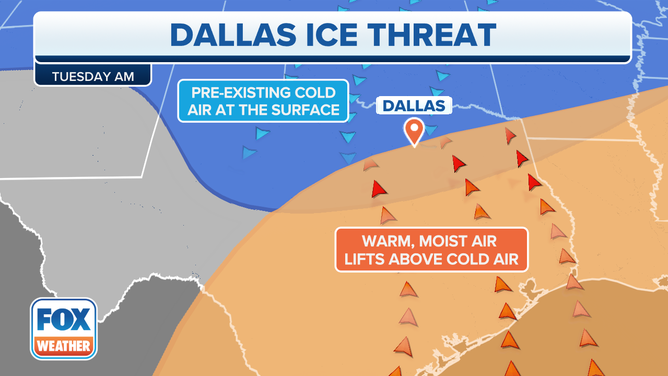
Tuesday morning the ice threat extends from central Texas to southern Arkansas.
(FOX Weather)
The National Weather Service has issued Winter Storm and Ice Storm Warnings for millions of people living in Texas from the Dallas-Fort Worth Metroplex southward through Waco and Austin, as well as to the west into Abilene, San Angelo and Junction.
Freezing rain has also been reported in parts of Arkansas and West Tennessee, including Little Rock and Memphis in those respective states, leading to Ice Storm Warnings there too.

(FOX Weather)
Ice accretions could reach upward of a quarter-inch in this region, likely leading to power outages and dangerous travel conditions.
WHY DO BRIDGES AND OVERPASSES FREEZE BEFORE ROADS?
Ice storm creates travel nightmare
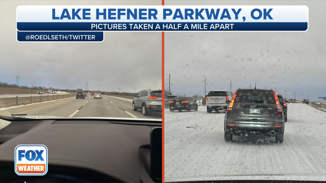
![Photos taken just a half-mile apart show clear driving conditions and then a sleet-covered roadway on Lake Hefner Parkway in Oklahoma.]() Image 1 of 5
Image 1 of 5Photos taken just a half-mile apart show clear driving conditions and then a sleet-covered roadway on Lake Hefner Parkway in Oklahoma. (@Roedlseth / Twitter)
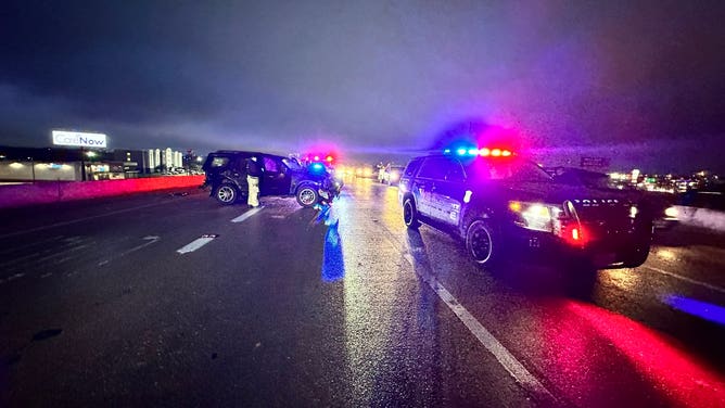
![Icy crashes in Dallas area]() Image 2 of 5
Image 2 of 5A major crash northbound Loop 820 in Arlington, Texas on Jan. 30, 2023 as freezing rain plagues the Dallas area. (Christopher Cook / @cooktx / Twitter)
![Icy crashes in Dallas area]() Image 3 of 5
Image 3 of 5A major crash northbound Loop 820 in Arlington, Texas on Jan. 30, 2023 as freezing rain plagues the Dallas area. (Christopher Cook / @cooktx / Twitter)
![Icy crashes in Dallas area]() Image 4 of 5
Image 4 of 5A major crash northbound Loop 820 in Arlington, Texas on Jan. 30, 2023 as freezing rain plagues the Dallas area. (Christopher Cook / @cooktx / Twitter)
![Icy crashes in Dallas area]() Image 5 of 5
Image 5 of 5A major crash northbound Loop 820 in Arlington, Texas on Jan. 30, 2023 as freezing rain plagues the Dallas area. (Christopher Cook / @cooktx / Twitter)

Driving proved nearly impossible for morning and evening commutes for millions on Monday and Tuesday. Rain or slushy snow fell through warm air to the surface that was freezing below. That water then solidified into a sheet of ice along the Interstate 35 corridor from Oklahoma City to Dallas.
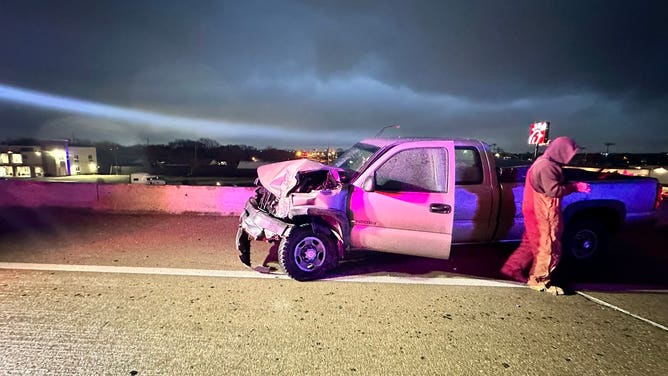
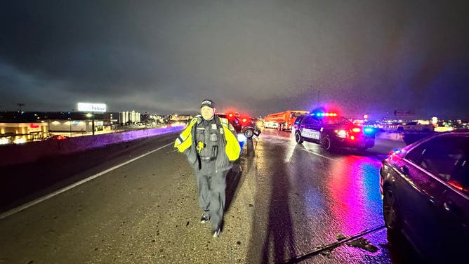
Crashes were reported across the region, including a major crash on Loop 820 in Arlington, Texas, on Monday.
"Bridges and overpasses are considered treacherous," White Settlement, Texas, police chief Christopher Cook said in a Tweet. "People must slow down when approaching elevated surfaces."
Several schools in Texas decided to close early and cancel after-school activities because of the inclement weather, including the Fort Worth Independent School District.
Oklahoma State University in Oklahoma City also decided to close campus at noon on Monday.
Flights into and out of the region were also impacted, with Dallas/Fort Worth International Airport (DFW) leading the pack with the most flight cancelations and delays. By Monday night, Dallas airports saw more than 500 flight cancellations.
Major delays were also expected at airports from Dallas to Little Rock.
On Tuesday morning, FOX 4 Dallas reported hundreds of drivers were stuck in a 20-mile traffic backup on I-20 in Palo Pinto and Parker counties because of icy road conditions.
Austin-Travis County EMS said in several tweets that they were responding to crashes all over the region, including one in which two people either jumped or were hit and thrown from a bridge during a multi-vehicle crash in icy conditions.
Several ambulances also responded to reports of a multi-vehicle crash that involved an auto-pedestrian collision. EMS officials said at least one person was killed.
THE HIDDEN DANGERS OF ICE STORMS. HERE’S WHAT YOU NEED TO KNOW
More to come

(FOX Weather)
A second, more impactful wave of winter precipitation began on Tuesday morning, with a large area of precipitation breaking out in West Texas. A continued push of colder air in the wake of the arctic front has allowed the freezing line to inch further south, well past the I-20 corridor.
The FOX Forecast Center believes this area is where impacts could be the greatest, as potentially up to a half-inch of ice accretion is possible along a line from Abilene in West Texas eastward into North Texas and southern Oklahoma.
Up to a half-inch of ice could also fall in parts of Arkansas, Mississippi and Tennessee.

(FOX Weather)
"We are talking about the high potential for power outages," FOX Weather meteorologist Britta Merwin said. "And once the power is out, you have to keep you and your family warm in a safe way. So, this is something to watch very closely."
As of Tuesday morning, tens of thousands of people were without power because of the storm.
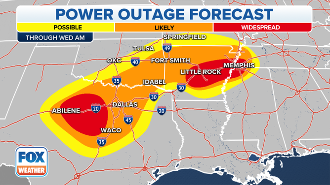
The potential for power outages through Wednesday morning.
(FOX Weather)
HERE'S WHAT TO HAVE ON HAND IF THE POWER GOES OUT DURING A WINTER STORM
Texas freezing rain threat holds into Wednesday
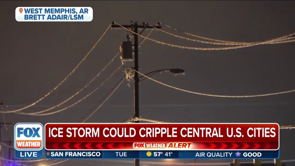
Long-duration ice storm could cripple cities across Central U.S.
Field Meteorologist Brett Adair talks about the impacts he's seeing from the ice storm in West Memphis, Arkansas and the impacts it could have in the days to come.
From Tuesday into Wednesday, the FOX Forecast center expects continued precipitation to fall across most of Texas. While precipitation will begin to taper off in intensity, the freezing drizzle will continue to complicate the forecast, as multiple hours of freezing rain from Tuesday night into Wednesday could lead to a slippery commute Wednesday morning.
During the day Wednesday, temperatures will begin to thaw out due to an approaching weather system.
Temperatures will warm above freezing by Wednesday afternoon, ending the threat of additional ice accretion. But with temperatures dropping back below freezing Wednesday night, refreezing will be possible overnight and into early Thursday, which could lead to multiple instances of black ice for the Thursday morning commute across most of West and North Texas.
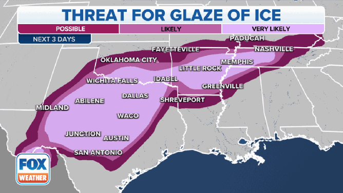
The ice threat over the next three days.
(FOX Weather)
Overall, the forecast calls for upward of a quarter- to half-inch of ice to accrete starting along the I-20 corridor in West Texas, stretching eastward toward I-35, and eventually into parts of southeastern Oklahoma and southern Arkansas. A second area of ice upward of a quarter-inch is also increasingly likely across other parts of Arkansas and into West Tennessee.
Generally, ice accretions of less than a quarter-inch are considered to be a nuisance, but impacts start to become disruptive once amounts close in on a half-inch or more.
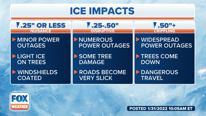
Ice impacts explainer.
(FOX Weather)
At around a half-inch, power outages can become numerous, and driving is considered hazardous.
Dangerous travel is likely, especially during commute times, along with some power outages. This will likely be a memorable ice storm for some, and there is a possibility that some locations could reach the threshold of crippling ice over a half-inch, should the cold air sink farther south than computer forecast models suggest, or precipitation falls in greater amounts than forecast.
HOW MUCH SNOW DOES YOUR CITY NORMALLY GET IN A YEAR?
ERCOT, Texas’ electric power grid manager, said it is monitoring the threat of frozen precipitation for the Lone Star State but believes it will have enough electrical generation to meet the demands of its more than 26 million customers.
Computer forecast models show the threat of precipitation diminishing by the time the first weekend of February arrives.