10 minutes to danger: Arctic blast puts millions at risk of frostbite in Plains, Midwest
The FOX Forecast Center said the coldest days would be through Tuesday, but below-average temperatures will last all week. At this time, no records are forecast to fall.
Arctic blast to keep temperatures below average across Central States through Thursday
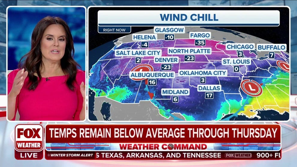
Arctic air is surging south into the central states where it will linger through much of the upcoming week. Dangerously cold -20 to -50 degree wind chills are expected with frostbite possible in 30 minutes or less on exposed skin.
Arctic air has taken hold across the central part of the country bringing some of the coldest air to the area since December.
The FOX Forecast Center said the coldest days would be through Tuesday, but below-average temperatures will last all week. At this time, no records are forecast to fall.
FILE - A commuter makes her way to work in sub-zero temperatures on January 2, 2018, in Chicago, Illinois.
(Scott Olson / Getty Images)
Temperatures in dangerously cold territory
At night, lows will drop below zero for more than 20 million people across parts of 15 states from Idaho to Michigan.
Below-zero air temperatures and negative 10- to negative 20-degree wind chills made it as far south as Kansas and as far east as Illinois on Tuesday morning.
The last time the Mars Curiosity Rover reported high temperatures, they averaged around 7 degrees. Afternoon highs Monday in Idaho Falls and Rexburg, Idaho, were negative 4 degrees and negative 2 degrees, making both places colder than your typical Martian afternoon this time of year, the National Weather Service in Pocatello said.
With temperature like this, Wind Chill Warnings and Advisories were in effect from the Rockies through the Plains and Upper Midwest, where frostbite and hypothermia can set in as little as 10 minutes. Precautions need to be taken by anyone in those regions through at least Tuesday.
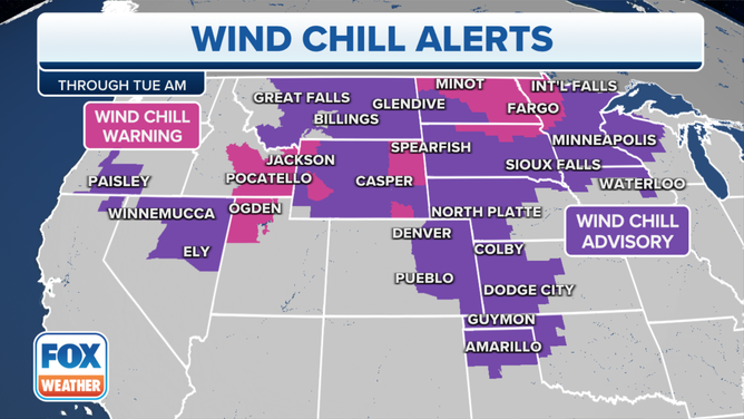
Here's a look at the Wind Chill Warnings and Advisories issued.
(FOX Weather)
"We’re talking about dangerous air where you do need to change how you’re acting," FOX Weather meteorologist Britta Merwin said. "You want to limit how much time you’re outside. And if you do choose to go outside, everything needs to be covered."
Temperatures will begin to slightly warm starting Wednesday, but nighttime temperatures in the single digits to below zero will continue through the week.
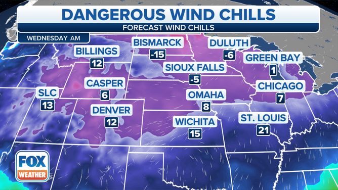
Nighttime temperatures in the single digits to below zero will continue through the week.
(FOX Weather)
Much like those to the north, temperatures in the Southern Plains will moderate starting Wednesday into the 30s and 40s but this will still be below average for this time of year.
Near-average temperatures will return to the central U.S. by next weekend.
Southeast spared from dangerous cold
As the Arctic blast sweeps through the Plains and Midwest, the South may be spared from the dangerous cold.
"We have this big ridge of high pressure that’s dropped into the northern stack of our country, and that’s locking onto that arctic air and surging it all the way down to Texas," Merwin said. "This is actually part of the player for the ice storm that’s unfolding today for Texas and Oklahoma."

Forecast highs for the South on Tuesday.
(FOX Forecast Center / FOX Weather)
Unlike December’s record cold blast that made it all the way to Florida, the latest intrusion of cold air will be limited by how far it sinks to the south.
Cold air is sinking into northwestern Texas and the Ohio Valley, but the most dangerous conditions will remain across the northern tier of the country due to a ridge of high pressure over the Southeast.