Hurricane Hunters to investigate Gulf of Mexico tropical disturbance bringing heavy rain to Florida
An area of low pressure over the Gulf of Mexico is tracking toward Florida, and while the odds of a tropical depression or storm forming are low, it is a system the FOX Forecast Center will be monitoring as the Atlantic hurricane season begins.
FOX Weather monitors tropical disturbance in Gulf of Mexico
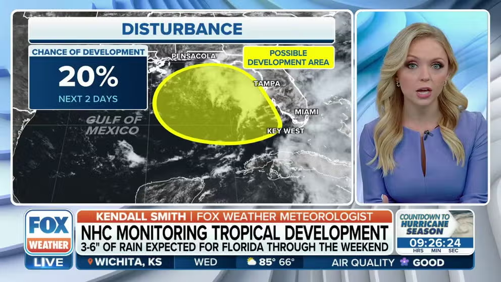
Development odds on a tropical disturbance in the Gulf of Mexico have been increased slightly for the next two days. It is expected to bring heavy rain to Florida this week.
We’re now less than one day until the official start of the Atlantic hurricane season, and right on cue, a tropical disturbance in the Gulf of Mexico is expected to dump widespread heavy rain and thunderstorms with gusty winds on Florida starting Wednesday and lasting through the weekend.
This comes after parts of the Sunshine State saw up to 10 inches of rain last week before a little break in the storms over the last few days.
Tropical development possible in the Gulf of Mexico

(FOX Weather)
The National Hurricane Center (NHC) has highlighted a disturbance in the northeastern Gulf of Mexico for possible tropical development over the coming days.
The NHC said there is an area of disorganized showers and thunderstorms associated with an area of low pressure situated over the warm waters of the Gulf of Mexico. Forecasters have given the tropical disturbance a 20% chance of developing into a tropical depression or storm over the next two days and a 20% chance of developing over the next seven days.
WHERE TROPICAL STORMS, HURRICANES TYPICALLY OCCUR DURING EACH MONTH OF ATLANTIC HURRICANE SEASON
Environmental conditions only appear marginally favorable for additional development over the next several days while the system slowly spins over the eastern Gulf of Mexico.
"A low-pressure system in the Gulf of Mexico must always be monitored for possible tropical development this time of year," FOX Weather senior digital meteorologist Brian Donegan said. "While the odds of a tropical depression or storm forming are low, this system is still expected to provide a surge of tropical moisture to Florida late this week and into the weekend, regardless of development."
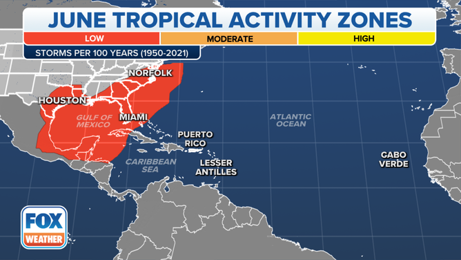
This map shows where tropical cyclone activity tends to occur during June. The data are shown as the combined number of tropical depressions, tropical storms and hurricanes whose centers pass within 125 miles of a point on the map during a 100-year period. The analysis is based on data from the 72-year period from 1950 to 2021 but normalized to 100 years.
(FOX Weather)
On Wednesday, the Hurricane Hunters said they plan to begin investigating the storm Thursday with their first mission of hurricane season departing at 1:45 p.m. EDT. A second mission into the storm is expected to take off at 6:15 a.m. EDT Friday.
Be sure to download the free FOX Weather app to keep up with forecast changes and be alerted of any severe weather events in your area.
HERE'S WHY THE ATLANTIC HURRICANE SEASON RUNS FROM JUNE TO NOVEMBER
How much rain will fall in Florida this week?
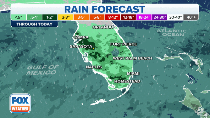
Forecasted rain totals in Florida through Saturday, June 3, 2023.
(FOX Weather)
The highest rainfall amounts are expected to fall across portions of Central and South Florida from the Tampa and Orlando areas south through Melbourne, Fort Pierce, West Palm Beach and Miami.
Through Wednesday, the Tampa and Sarasota areas can expect between 1 and 2 inches of rain from any storms that develop during the day.
Later this week and into the weekend, higher rain totals are expected across the southern half of the state. Most of Central and South Florida will see upwards of 2-3 inches of rain, but many areas could see even higher totals.
Areas like Tampa and Sarasota on the western side of the state, as well as West Palm Beach, Miami and Homestead in South Florida, could see 3-5 inches of rain through Saturday, with some spots seeing locally higher amounts.
PEAK FLASH FLOOD SEASON IN US BEGINS IN JUNE
Florida faces flash flood threat starting Wednesday
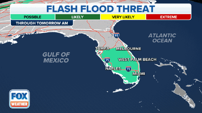
The flash flood threat in Florida through Sunday, June 4, 2023.
(FOX Weather)
With the copious amounts of rain expected starting Wednesday, the Sunshine State will be facing a flash flood threat through at least Sunday.
Flash flooding will be possible across the southern half of the state from Tampa and Melbourne south through Naples and Miami.
Starting Thursday, the flash flood threat will expand to include areas farther north, including the Orlando and Daytona Beach areas.
Will the rain help drought conditions in Florida?

(FOX Weather)
Recent rain in Florida has helped to reduce some of the drought conditions in the state, but most of the rain has been centered across southwestern areas, while areas on the Sunshine State's west coast are still extremely dry.
"I mean, look at Tampa, Sarasota, the St. Petersburg area," FOX Weather meteorologist Jason Frazer said, noting the extensive drought in the region. "You are on a Category 4 out of 5 (drought). And whenever we talk about a Category 4 out of 5 here, I mean, we’re talking about some of the worst here."
Frazer said Tampa needs about 2-3 inches of additional rain to ease a lot of the drought conditions in that area.
WHAT TO EXPECT IN THE TROPICS AS ATLANTIC HURRICANE SEASON BEGINS
Tropical mischief in June is common in the Gulf of Mexico
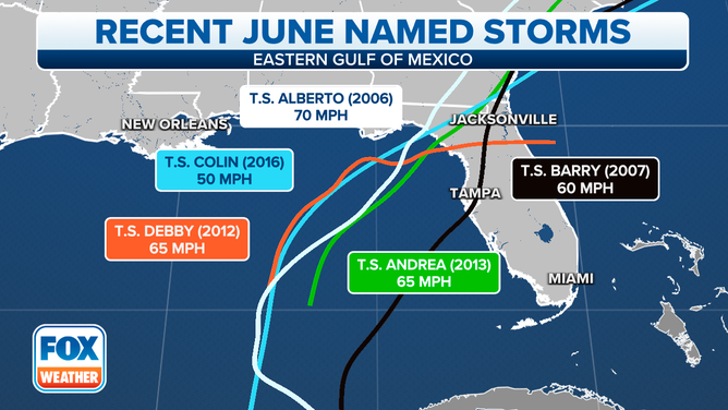
Recent June named storms
(FOX Weather)
The Gulf of Mexico, northwestern Caribbean Sea and western Atlantic are the climatologically favored regions for tropical development in early June.
The FOX Forecast Center said due to marginal atmospheric conditions, tropical cyclones usually never reach hurricane status and remain either a tropical depression or tropical storm during their lifecycle.
The last named storm to make landfall during June along Florida's west coast was Tropical Storm Colin in 2016.
The first named storm typically forms around June 20, according to NHC data.