Rare threat level 4/5 issued as dangerous severe weather outbreak threatens 180+ million in major threat zone
On Monday, the threat level was upgraded to a rare level 4/5 for destructive severe weather and even long-track tornadoes along the East Coast, including the nation's capital, Washington, DC.

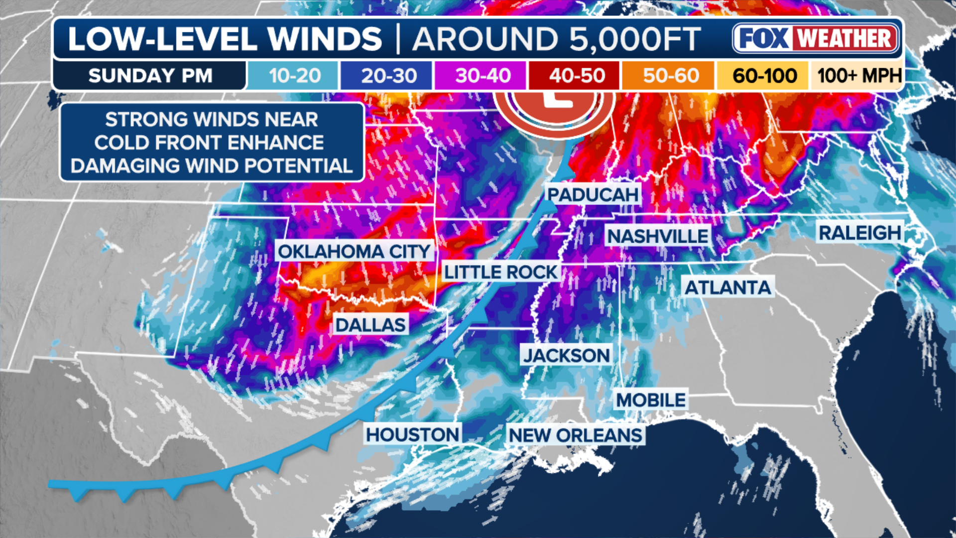
Intensifying storm threat across the Midwest and Mississippi Valley
SIGNIFICANT THREAT ‼️: Thunderstorms packing damaging winds and tornadoes are possible from Louisiana to Illinois Sunday afternoon. The threat for winds and tornadoes continues into the East on Monday.
A widespread and significant severe weather outbreak is developing for over 180 million Americans, as destructive impacts start on Sunday afternoon in the Heartland and will last through Monday evening along the East Coast.
A level 3 out of 5 severe weather risk is in place today for millions in the Heartland as near-hurricane force wind gusts and strong tornadoes are all possible.
On Monday, the threat level was upgraded to a rare level 4 out of 5 for destructive severe weather and even long-track tornadoes along the East Coast, including the nation's capital, Washington, DC.

BETHESDA, MARYLAND - MAY 16: In an aerial view, severe thunderstorms move through the Washington, D.C. metropolitan area causing widespread damage on May 16, 2025, in Bethesda, Maryland.
(Kevin Carter / Getty Images)
The FOX Forecast Center said by tonight, a destructive line of severe storms will develop across the Midwest and stretch into the Southeast, unleashing widespread damaging wind gusts up to potentially 75+ mph.
A level 3 out of 5 severe weather threat is in place for parts of Illinois, Indiana, Kentucky, Missouri and Tennessee, Arkansas, Louisiana, Mississippi and Alabama on Sunday.

(FOX Weather)
The FOX Forecast Center said that any individual storm that forms ahead of the main line of storms will have a significant chance of rotating and producing tornadoes, some of which could be strong and stay on the ground for a long time.
HOW PUBLIC SAFETY OFFICIALS NOTIFY YOU DURING SEVERE WEATHER EMERGENCIES
By Monday, the severe threat will move east over Georgia, the Carolinas, Virginia, up into Pennsylvania and New Jersey, with a high risk for dangerous winds and strong tornadoes.
TWISTER TERROR 🌪️: Monstrous tornado caught on camera as it tore through Union City, Michigan, leveling homes and unleashing devastating damage in its path. Stay with FOX Weather for LIVE coverage reporting the ground truth from Michigan in the aftermath of these deadly storms… pic.twitter.com/oofy4YFjNn
— FOX Weather (@foxweather) March 7, 2026
The most significant threat will be in northeastern South Carolina, most of central and eastern North Carolina, eastern Virginia and up north to Washington, D.C., where the level 4 out of 5 severe risk exists.
Widespread power outages and damage will be possible during these destructive, fast-moving storms.

(FOX Weather)
Two rounds of storms are likely, with the first bringing a more serious tornado threat for the Carolinas and Virginia by Monday afternoon.
TORNADO SAFETY: THE SAFEST AREAS TO PROTECT YOURSELF AND WHY TO AVOID OVERPASSES
The second round will move in closer to the cold front, bringing more instability and strong wind shear.
(FOX Weather)
Cold front to bring March chill to East
The weekend bomb cyclone pushing through the Midwest and Great Lakes will help drive strong northwest winds behind the storm, pulling Arctic air south and east.
The Plains and Midwest will be the first to see a significant temperature shift on Monday as a bitter blast of Arctic air moves across the country.

People visit the cherry blossom trees during their peak bloom stage at the Tidal Basin in Washington, D.C. on March 28, 2025.
(Bryan Dozier / Middle East Images / Middle East Images via AFP / Getty Images)
Afternoon highs on Monday will be nearly 15-25 degrees below average, peaking in the teens and 20s across the Midwest and in the 40s and 50s across the Mid-South. These below-average temperatures will extend from the Canadian border all the way south to the Texas–Mexico border.
HERE'S HOW TO KEEP YOUR FURRY FRIENDS SAFE THIS WINTER SEASON
Overnight into early Tuesday, wind chill values will drop into the negative single digits and teens for cities such as Minneapolis and Green Bay, and into the teens and 20s for areas like Oklahoma City and Atlanta.
![Monday forecast lows]() Image 1 of 3
Image 1 of 3Monday forecast lows
![Tuesday forecast lows]() Image 2 of 3
Image 2 of 3Tuesday forecast lows
![Wednesday forecast lows]() Image 3 of 3
Image 3 of 3Wednesday forecast lows ( )


In the Deep South, a few record low temperatures are possible.
By Tuesday, nearly 225 million Americans are expected to experience below-average temperatures.
The most widespread below-average temperatures will arise on Tuesday afternoon. Highs will once again run nearly 20-30 degrees below average for major cities such as St. Louis, Atlanta and Washington, DC.
HERE'S WHAT YOU NEED TO KNOW TO STAY SAFE AT THE BEACH DURING SPRING BREAK
Many areas will remain in the mid-30s on Tuesday. By Wednesday morning, New York City and Boston will wake up to temperatures in the upper teens and 20s.

(FOX Weather)
Temperatures slowly warm closer to average by Wednesday and Thursday.
Long-range temperature outlooks suggest parts of the Northeast could see below-average temperatures into late March.