The Daily Weather Update from FOX Weather: More storms with heavy rain, mountain snow to slam California
Start your day with the latest weather news – Another series of powerful storms is slamming the West Coast, including waterlogged California while millions of people in the eastern U.S. deal with below-average temperatures.
Series of storms to slam West with more heavy rain, feet of snow for California
After a wet and snowy Sunday, the pattern continues to reload bringing more rounds of storms to the region. This will only serve to increase the risk for flooding and widespread impacts. This pattern is being fueled by a favorable storm track and a strong jet stream.
Welcome to the Daily Weather Update from FOX Weather. It’s Monday, March 20, 2023, and also the first day of spring. Start your day the right way with everything you need to know about today's weather. You can also get a quick briefing of national, regional and local weather whenever you like with the FOX Weather Update podcast.
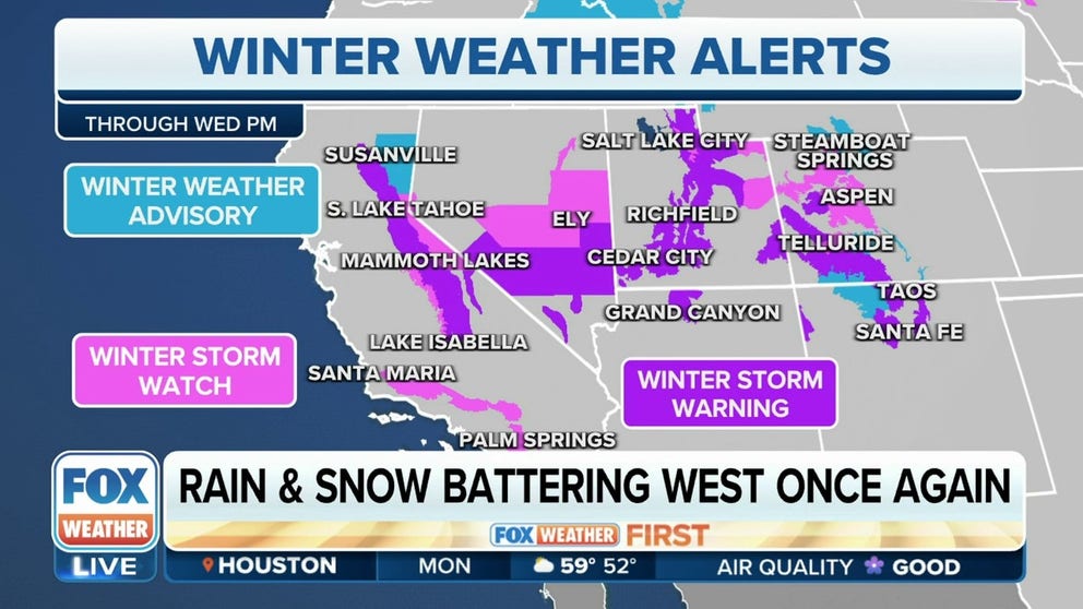
More torrential rain, mountain snow headed for California, West Coast
Another series of strong storms will bring more heavy rain and mountain snow to the West, including waterlogged California, in the week ahead.
The first storm brought heavy rain and snow to Northern California on Sunday, and while that system exits the region Monday, the second storm will swoop in and bring precipitation to Southern California and parts of the Southwest.
An additional 1 to 3 inches of rain is expected from this next system through Wednesday. The heavy rain will also lead to a flash flood threat in Southern California, including the Los Angeles area.
Between 1 and 3 feet of additional snow is expected across the Sierra Nevada through Monday, with 2 to 4 more feet possible from late Monday night through Wednesday afternoon.
Gusty winds over 30 mph will also be an issue, and blowing snow will reduce visibility on the roads. Travel is discouraged as these conditions will make driving dangerous.

(FOX Weather)
Things to know:
- Ridiculous photos show aftermath of 12 feet of snow in California's Sierra Nevada
- Watch: Stranded man rescued from island after raging California river swept his car away
- What California's excessive snow, rain mean for state's reservoirs
Multiday severe weather threat looms later this week
Spring begins the typical uptick in tornadoes across the U.S., and right on cue, a multiday severe weather threat with tornadoes, damaging winds and large hail looms for parts of the South in the season's first week.
An area of low pressure will move east out of the Rockies around the middle of the week and track across the central and eastern U.S. by midweek.
The severe weather threat will then likely ramp up beginning Thursday in the southern Plains, with the highest threat of severe thunderstorms expected to be near the cold front across portions of Oklahoma and northern Texas on Thursday afternoon, potentially continuing into Thursday night in some areas.
Tornadoes, large hail and damaging winds are all the main threats with these severe thunderstorms.
The severe weather threat will shift east on Friday, with the highest threat stretching from the lower Mississippi Valley into parts of the Southeast.
Like Thursday, severe thunderstorms on Friday will have threats of tornadoes, large hail and damaging wind gusts.

(FOX Weather)
Welcome, spring!
Spring in the Northern Hemisphere officially begins on Monday with the vernal equinox as the whole world experiences an equal amount of daylight and darkness.
Astronomical seasons are based on the position of the Earth with respect to the sun as the planet makes its annual revolution around the closest star.
Meteorologists and climatologists consider March 1 the first day of spring, but astronomically speaking, the Earth’s equator is aligned directly with the sun on the vernal equinox. This year, that occurs today at 5:24 p.m. EDT.
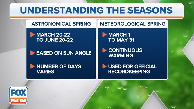
The start of spring depends on whether you're referring to the astronomical or the meteorological start.
(FOX Weather)
Bonus Reads:
- We're entering America's most active time of year for tornadoes
- How warm will spring be? NOAA season outlook shows who can pack up those winter coats
- When and how to see Mercury, Venus, Mars, Jupiter and Uranus at the same time
Need more weather? Check your local forecast plus 3D radar in the FOX Weather app. You can also watch FOX Weather wherever you go using the FOX Weather app, at foxweather.com/live or on your favorite streaming service.