Cross-country storm set to bring severe weather, snow to US starts this weekend
The action kicks off Sunday in the western U.S. and will eventually push across the country, where it will finally impact the East Coast by Thursday.
Major severe threat returning to central US next week
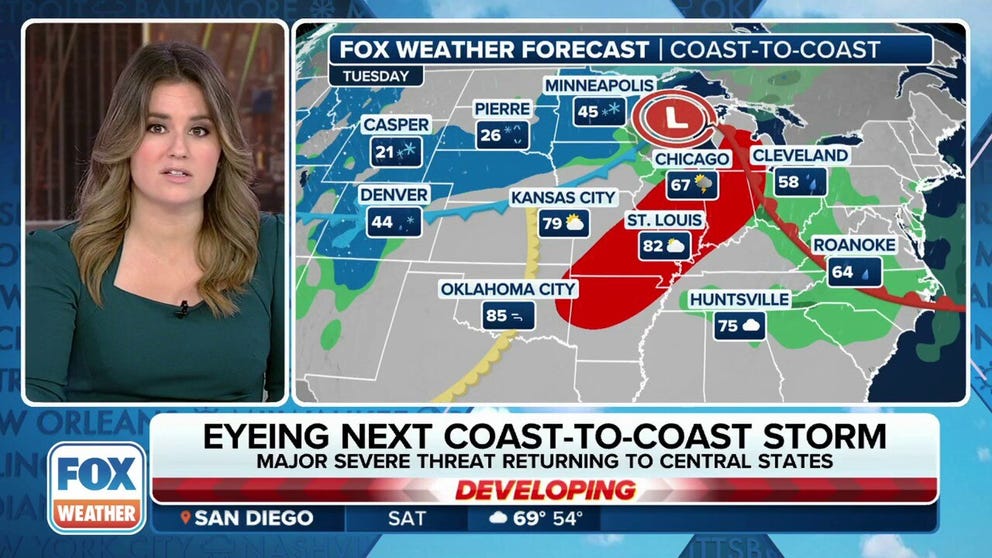
A new week will bring a new round of active weather across the country as a strong storm is expected to bring impacts from coast-to-coast. Different threats will affect multiple regions including heavy snow, widespread rain, severe storms and high wind gusts.
FOX Weather's continuing coverage of this week's cross-country storm has moved to this link.
The FOX Forecast Center is tracking a potentially dangerous storm system that’s expected to impact most, if not all, of the Lower 48 during the next week with some form of precipitation, including the potential for severe weather, heavy mountain snow and rain.

(FOX Weather)
The action kicks off Sunday in the western U.S. and will eventually push across the country, where it will finally impact the East Coast by Thursday.
"We’ve got some energy, believe it or not, is way the heck up north of the Aleutian Island chain in Alaska," FOX Weather Meteorologist Bob Van Dillen said. "But by next week, it is going to dive right down the coast of Canada into the Pacific Northwest, ultimately turning into a low-pressure region that will be north of the Rockies."
DOWNLOAD THE FREE FOX WEATHER APP

(FOX Weather)
The FOX Forecast Center said the storm will be colder, which will cause snow levels to drop and allow snowfall to pile up across the western mountain chains in the U.S.
This is especially beneficial in the Northwest and will be the most significant storm since January. The snowpack there is hovering around 50% of the average, so the snow expected from this storm could boost that.
More rain is also expected in California, and although the rain amounts are expected to be much lower than what the state just experienced from a multiday atmospheric river storm this past week, there will be a threat of additional landslides and mudslides because the ground is so saturated.
The FOX Forecast Center said high winds are also expected across the interior West behind some cold fronts moving through the region on Monday and Tuesday.
DRIVING ON THE ICE AND DRIVING IN THE SNOW: WEATHER DRIVING TIPS FOR DRIVING IN INCLEMENT WEATHER

(FOX Weather)
"It’s going to be a deep trough, which means it’s going to be just stacked up across the atmosphere," Van Dillen said. "That allows for moisture and heat to come off the Gulf of Mexico."
That will set the stage for the possibility of the development of severe thunderstorms on Tuesday and Wednesday.
ADVICE FOR DEALING WITH STORM ANXIETY WHEN SEVERE WEATHER THREATENS
Chicago, St. Louis among 28 million at risk of severe weather Tuesday
Chicago, Indianapolis, Nashville included in multiday severe weather threat next week
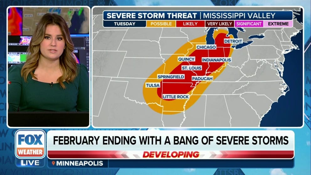
Tens of millions of people from the Midwest to the Tennessee Valley are at risk of seeing severe weather on Tuesday and Wednesday, and some of the thunderstorms that develop could pack a punch.
We’re still a few days out, but NOAA’s Storm Prediction Center (SPC) has highlighted areas of concern on Tuesday and Wednesday of the upcoming workweek that have the potential of seeing strong to severe thunderstorms.
"We have a severe weather threat, a multiday threat that’s going to hit many cities," FOX Weather Meteorologist Jane Minar said.

(FOX Weather)
As of Saturday, the SPC has placed more than 28 million in cities from the Ozarks in Missouri and Arkansas northward to the southern Great Lakes in a Level 2 out of 5 on its 5-point severe thunderstorm risk scale.
Cities at risk include Little Rock in Arkansas, Springfield, Jefferson City and St. Louis in Missouri, Springfield and Chicago in Illinois and Indianapolis and Fort Wayne in Indiana.
A large portion of central and southern Michigan is also included in the Level 2 threat, but so far, Detroit has only been placed in a Level 1 threat.
That could change, however.
"In fact, the severe weather threat has shifted a little bit farther to the north this morning," Minar continued. "There’s going to be a couple of changes day by day as we get into the start of the week."
The SPC says thunderstorms will develop ahead of a cold front during the late afternoon and into the early evening hours on Tuesday.
Main threats from any severe thunderstorms that do develop include damaging wind gusts and possible tornadoes, especially within supercell thunderstorms that develop and with stronger bowing line segments.
WATCH VS. WARNING: HERE ARE THE DIFFERENCES BETWEEN THESE WEATHER TERMS THAT COULD SAVE YOUR LIFE
Wednesday's severe weather threat covers Memphis, Nashville

(FOX Weather)
"As we go through Tuesday night, these storms, they’re expected to hold together, and we’re going to keep them going through the day on Wednesday," Minar said. "Right now, the discussion is, we could see these storms a bit more feisty in the morning hours into the afternoon and then diminishing from there."
The SPC said the front is expected to be located in far western Kentucky and far northwestern Tennessee during the early morning hours Wednesday, and there could be multiple lines of storms just ahead of it.
That means the Wednesday morning commute could be tricky and could slow travel times as storms push through.
As of Sunday afternoon, the SPC has more than 10 million people in a Level 2 out of 5 risk from parts of northern Mississippi and northern Alabama and northward to the Ohio River just north of Louisville in Kentucky at risk.
Other cities in the Level 2 risk include Memphis, Jackson and Nashville in Tennessee and Bowling Green and Louisville in Kentucky.
WHY DOES THE SKY SOMETIMES TURN GREEN DURING THUNDERSTORMS?

(FOX Weather)
The system will then reach the East Coast later in the workweek. By that time, the FOX Forecast Center said most, if not all, of the Lower 48 states will have seen some form of precipitation from this storm system.