Cross-country storm brings severe weather threat to Midwest with bitter blast of cold air in its wake
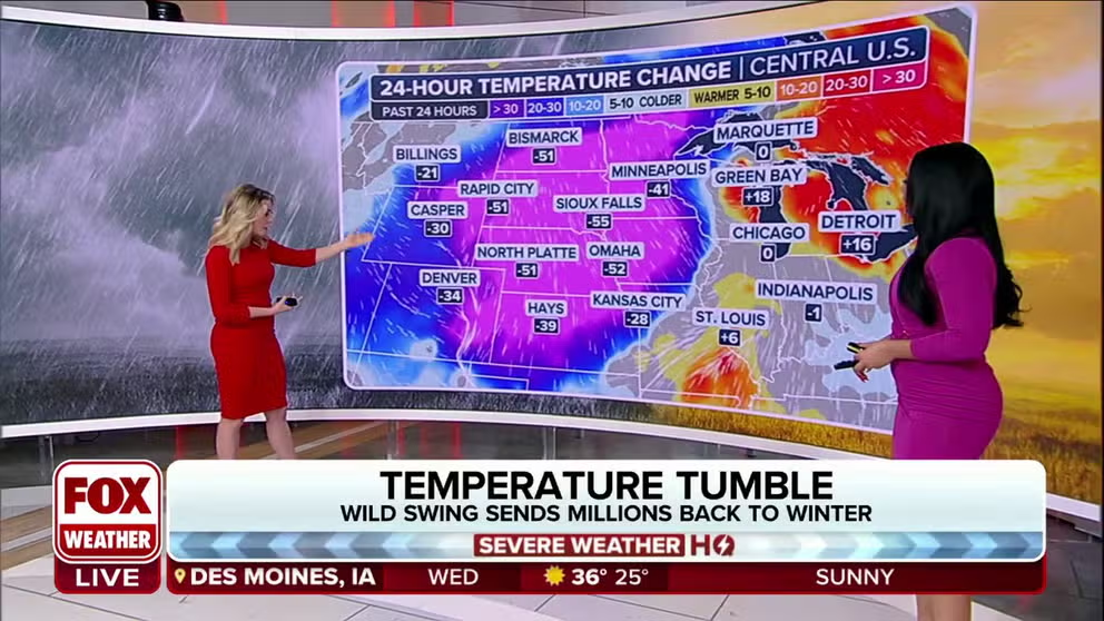
As the storm pushes across the U.S., temperatures are expected to plunge 50-60 degrees in a short period of time.
Record heat to freezing cold
After seeing the very first city hit the 100-degree mark for the year on Monday in Killeen, Texas; temperatures will tumble. FOX Weather tracks the cold air.
A powerful cross-country storm that impacted the West, dumping heavy snow in the mountains on Monday, has shifted to the east Tuesday where more than 55 million people in the Midwest and Great Lakes are on alert for severe weather. The storm's journey will continue into Wednesday when it will impact the eastern U.S. with widespread rain and some snow.

(FOX Weather)
Blizzard Warnings issued in Plains, Upper Midwest
The storm system is currently blasting the northern Plains and Upper Midwest with heavy snow and high winds, leading to Blizzard Warnings and strong words from officials not to travel due to the blowing and drifting snow.
The Blizzard Warnings were issued for counties in both North Dakota and Minnesota and included cities such as Grand Forks and Fargo in North Dakota, as well as Crookston and Twin Valley in Minnesota.

(FOX Weather)
The National Weather Service office in Grand Forks said the Blizzard Warning would continue until 6 p.m. CST on Tuesday due to additional snow accumulations of about 2 inches, as well as wind gusts as high as 50 mph.
The North Dakota Department of Transportation issued a No Travel Advisory for Grand Forks, Fargo, Jamestown and Valley City due to the blowing snow and near-zero visibility.
Elsewhere in the storm, the NWS said travel should be restricted to emergencies only. And, if travel is needed, drivers should bring a winter survival kit in case the vehicle becomes stuck.
Over 55 million on alert for severe weather in Midwest, Great Lakes
There are more than 55 million people from the Midwest to the southern Great Lakes and Ohio Valley that will be at risk of seeing severe weather on Tuesday.
However, NOAA's Storm Prediction Center (SPC) updated its severe weather outlook on Tuesday afternoon and now has more than 11 million people in a Level 3 out of 5 on its 5-point severe thunderstorm risk scale.
That Level 3 risk includes two areas: northern Illinois and southern Wisconsin, as well as an area stretching from southeastern Missouri to southwestern Ohio, including Paducah and Louisville in Kentucky, and Cincinnati.

(FOX Weather)
"Severe thunderstorms, associated with large hail, damaging (wind) gusts, and tornadoes, some of which may be significant, will be possible from late (Tuesday) afternoon into the overnight, across portions of the Ohio Valley and southern Great Lakes," the SPC said in its update.
Nearly 30 million people remain in the Level 2 risk for severe thunderstorms, including Chicago, Detroit, Indianapolis and Columbus.
St. Louis, which had been included in the Level 2 threat, saw its chances of severe weather lower earlier on Tuesday morning to a Level 1 risk.
NIGHTTIME TORNADOES FAR MORE LIKELY TO TURN DEADLY THAN DAYTIME ONES
![This graphic shows the tornado threat on Tuesday, Feb. 27, 2024.]() Image 1 of 3
Image 1 of 3This graphic shows the tornado threat on Tuesday, Feb. 27, 2024. (FOX Weather)
![This graphic shows the large hail threat on Tuesday, Feb. 27, 2024.]() Image 2 of 3
Image 2 of 3This graphic shows the large hail threat on Tuesday, Feb. 27, 2024. (FOX Weather)
![This graphic shows the damaging wind threat on Tuesday, Feb. 27, 2024.]() Image 3 of 3
Image 3 of 3This graphic shows the damaging wind threat on Tuesday, Feb. 27, 2024. (FOX Weather)


Widespread rain, some snow expected in the East

(FOX Weather)
The cross-country storm will continue to track eastward and begin to impact millions in the eastern U.S. by the middle of the week.
The FOX Forecast Center expects plenty of precipitation, including widespread rain and possible snow.

(FOX Weather)
The FOX forecast Center expects 1-2 inches of rain from portions of West Virginia through Pennsylvania in the Northeast, as well as across portions of New England.
However, rain totals of 2-3 inches are possible across portions of southeastern Connecticut, Rhode Island and southern Massachusetts. Portions of coastal Maine could also see higher rain totals.
Snow is also possible across portions of western and central New York state, as well as northern New England.
US goes from record-warm temperatures to bitter blast of cold air

(FOX Weather)
As the coast-to-coast storm system sweeps across the U.S., there will be a noticeable and dramatic shift in temperatures.
Hundreds of millions of people were experiencing springlike temperatures, but as the system pushes through, temperatures are expected to plunge 50-60 degrees in a short period of time.
"If you do the math, that's about 6 to 8 degrees of a temperature loss per hour," FOX Weather Meteorologist Britta Merwin said. "You notice that. You feel it. It's dramatic. We had record-breaking highs yesterday (Monday). We're going to have record-breaking highs today (Tuesday)."

(FOX Weather)
For example, Kansas City in Missouri has a forecast high of 78 degrees on Tuesday. And as the cold front pushes through, temperatures will plummet.
By Wednesday morning, temperatures could bottom out in the teens.