Coast-to-coast storm looms: Severe weather outbreak eyes South as blizzard could bury Plains, Midwest
Tornadoes, damaging winds and large hail are all threats from Tuesday into Wednesday across portions of the South. Meanwhile, heavy snow and possible blizzard conditions will likely pummel the northern Plains and Upper Midwest.
Severe weather outbreak eyes South; threats of tornadoes, damaging winds expected to begin Tuesday
The severe threat will peak Tuesday as ingredients come together to produce intense storms capable of tornadoes, large hail and damaging winds. Storms are expected to develop Tuesday afternoon across eastern Oklahoma and Texas then slide east where the threat for severe storms will peak.
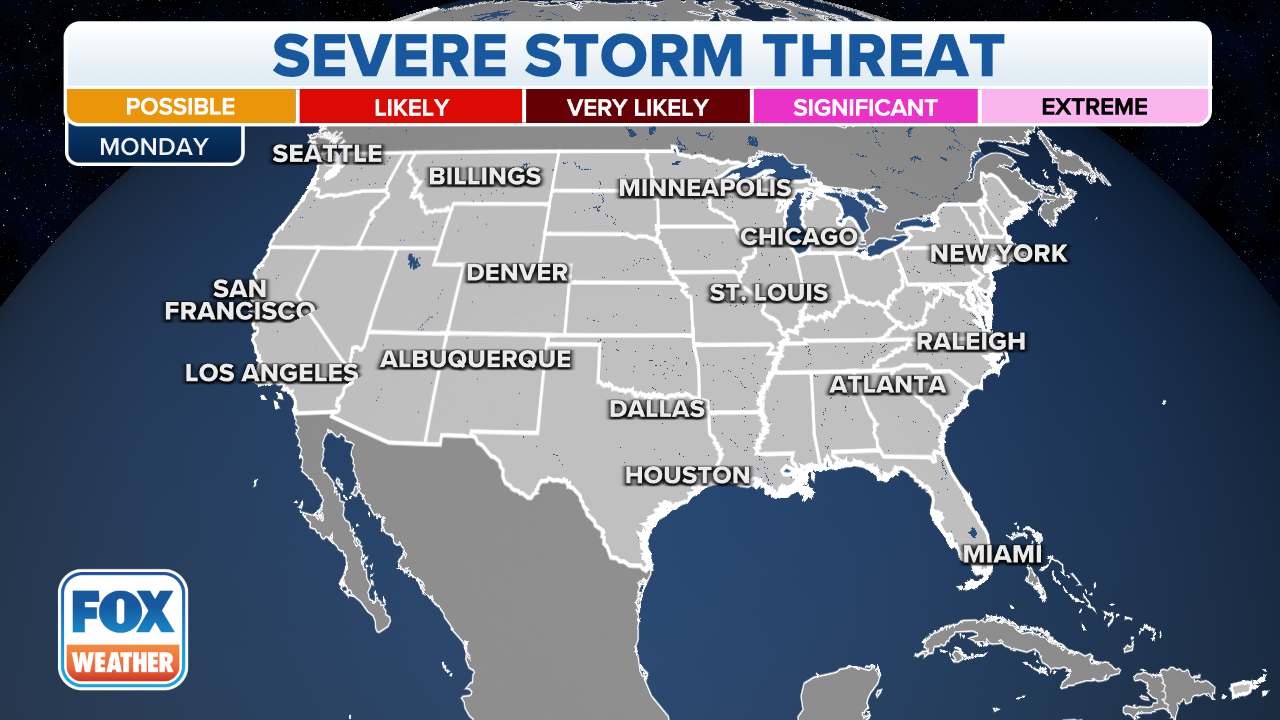
A coast-to-coast storm looms in the week ahead, and the impacts are expected to be significant along its journey across the country. That includes the potential for a dangerous severe weather outbreak in the South and a significant winter storm in the northern Plains and Upper Midwest that could bring heavy snow and blizzard conditions.
The powerful storm got underway over the weekend as a large upper-level low-pressure system continues to bury many western mountains in feet of snow. It will then punch eastward early this week into the central U.S., where it will receive an injection of moisture streaming north from the Gulf of Mexico.

(FOX Wether)
"We are under the threat (of severe weather) Monday evening all the way through Wednesday morning … maybe even Wednesday midday," FOX Weather meteorologist Amy Freeze said. "Areas to watch: southern Plains and lower Mississippi Valley. This is where we're going to be watching for the most serious weather."
Below is a general overview of what to expect from both the severe side and the wintry side of this coast-to-coast storm. For additional details, you can click here to read more about the severe weather threat, or you can click here to read more about the northern Plains blizzard.
Potential severe weather outbreak in South
A strong cold front associated with the area of low pressure will sweep east from the southern Plains into the lower Mississippi Valley and central Gulf Coast between Monday night and Wednesday. That front will provide the trigger for thunderstorm development as it pushes through a warm, humid air mass engulfing these regions.

(FOX Wether)
Monday night
An initial round of thunderstorms overnight Monday could turn strong to severe from portions of central Kansas southward to Oklahoma and western North Texas.
Large hail will likely be the primary threat from these storms, but a few strong wind gusts or even a brief tornado cannot be ruled out.
(FOX Wether)
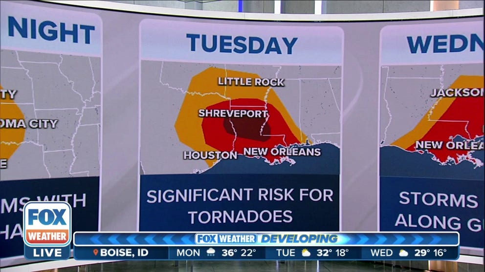
Tuesday-Tuesday night
Tuesday is expected to have the highest threat of severe weather in this potential outbreak. The locations at risk of severe thunderstorms will stretch from East Texas into southern Arkansas, Louisiana and western and southern Mississippi. That includes Alexandria, New Orleans and Shreveport in Louisiana, as well as Jackson and Vicksburg in Mississippi.
Within that region, there could be an even higher potential for severe weather in the area shaded in the darkest red on the map below, which includes far East Texas, southern Arkansas, northern and central Louisiana and far western Mississippi.
According to the FOX Forecast Center, tornadoes, damaging winds and large hail will all be possible, with the threat of dangerous storms continuing through the overnight hours and into early Wednesday morning in eastern portions of this region.
HOW YOU SHOULD PREPARE FOR A TORNADO

(FOX Weather)
Nighttime tornadoes are more than twice as likely to result in deaths than those that happen during the day because many people are asleep and caught unaware when a dangerous twister might be headed in their direction.
Make sure you have multiple ways of receiving potentially life-saving weather alerts issued by the National Weather Service, including one that will wake you up during the night.
NIGHTTIME TORNADOES FAR MORE LIKELY TO TURN DEADLY THAN DAYTIME ONES
Wednesday-Wednesday night
As this system moves farther east, additional severe thunderstorms are expected to fire up Wednesday from southeastern Louisiana into southern Mississippi and southwestern Alabama during the day. The severe weather threat could then continue into the overnight hours in the Florida Panhandle.
Once again, tornadoes, damaging winds and large hail will all be possible with Wednesday's round of storms. Cities at risk of severe thunderstorms include Baton Rouge and New Orleans in Louisiana, Biloxi and Gulfport in Mississippi and Mobile in Alabama.
THIS IS WHAT YOU SHOULD DO IF YOU ARE DRIVING AND THERE IS A TORNADO ON THE GROUND

(FOX Weather)
Major winter storm, blizzard conditions possible in northern Plains, Upper Midwest
After the storm dumps feet of snow across the western mountains this weekend, it will spread heavy snow and high winds into the northern Plains and Upper Midwest beginning late Monday and may linger over parts of those regions into at least the middle of the week.
Coast-to-coast storm to bring blizzard conditions to Plains starting Tuesday
Once the winter storm leaves the Rockies, it will become a powerful storm in the Plains next week. In addition to being a strong storm, this will be a long-duration event as the low pressure moves east ever so slowly.
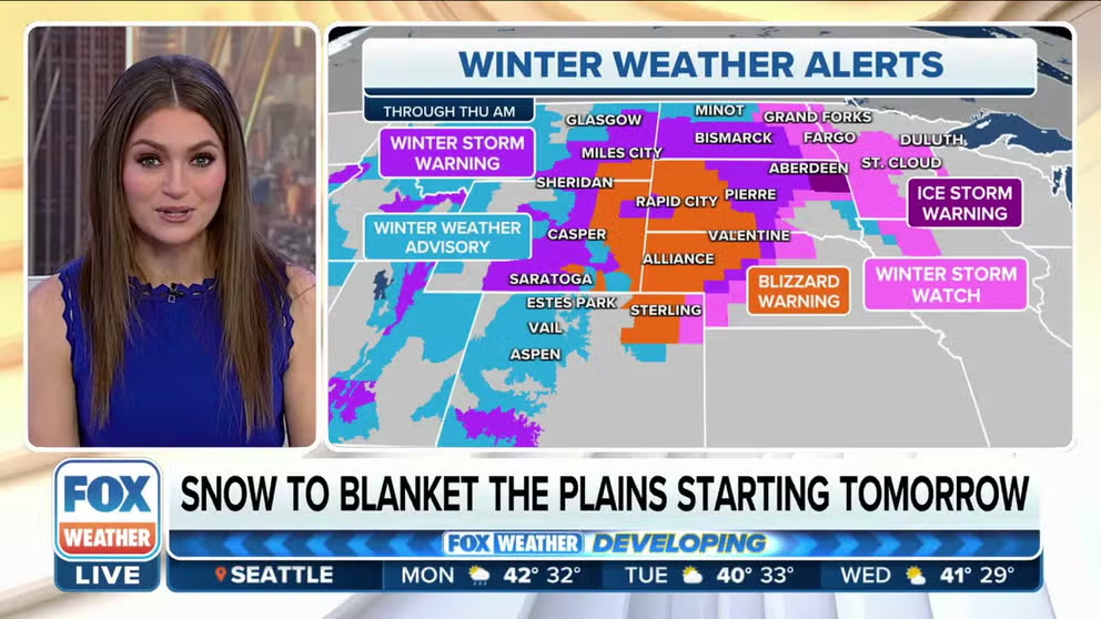
According to the FOX Forecast Center, parts of South Dakota and eastern Wyoming could be dealing with blizzard or near-blizzard conditions by sunrise Tuesday morning.
"Remember, that's blowing snow or falling snow, visibility drops to a quarter-mile or less (and) lasts for three hours," FOX Weather meteorologist Craig Herrera said when explaining what a blizzard means.
WHAT MAKES A BLIZZARD DIFFERENT FROM AN ORDINARY SNOWSTORM?
Travel will become extremely difficult, if not impossible, in these areas on Tuesday as the snow peaks in intensity and overlaps with 40- to 60-mph wind gusts. Snowfall rates could exceed an inch or two per hour.
On Wednesday, periods of heavy snow and 40- to 60-mph wind gusts will continue to pummel the northern Plains as the snow also expands into Minnesota and portions of northern Wisconsin. However, lower winds between 20 and 35 mph will prevent any blizzard conditions in the Upper Midwest.

(FOX Weather)
The winter storm should finally begin to exit the region on Thursday, though a few nuisance snow showers could linger in some areas into Friday.
Be sure to check back with FOX Weather for updates on both the severe side and the wintry side of this coast-to-coast storm in the week ahead.