California faces renewed flooding risk as more atmospheric river storms loom this week
California will remain on a break from the weather through the workweek, but a pair of storms is lining up once again to push through the Golden State starting this weekend and possibly lingering into next week.
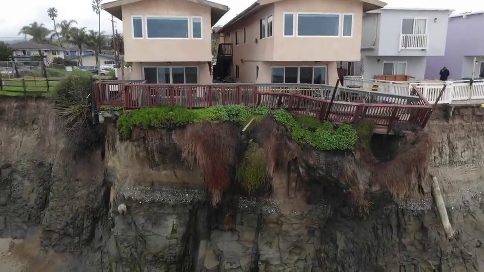
Drone video shows apartment units hanging after cliff erodes
Santa Barbara County official shot drone video of where a cliff began to erode in Isla Vista, California, on Tuesday.
LOS ANGELES – As California finally gets a period of sunny weather to wring out and clean up from record rainfall and deadly storms last week, long-range weather forecasts show a renewed flooding threat as the weather pattern reverts later this week.
California will remain on a break from the weather through the workweek except for a little rain in the San Francisco Bay Area from Wednesday into Thursday. But a pair of storms is lining up once again to push through the Golden State starting this weekend and possibly lingering into next week. Each storm could bring heavy rain and high winds to California, with heavy snow at higher elevations starting as early as Saturday and lasting well into next week.
(FOX Weather)
NOAA's Climate Prediction Center said there is a 40-60% chance of hazardous, heavy precipitation across much of California during that time frame, stretching from both its northern and southern borders into southern Nevada and Arizona.
"There is a flooding risk for much of California, especially in regions with saturated soils from heavy precipitation earlier in February," CPC forecasters wrote in a Key Message statement Monday.
SEE DESTRUCTION CAUSED BY ATMOSPHERIC RIVER POUNDING CALIFORNIA
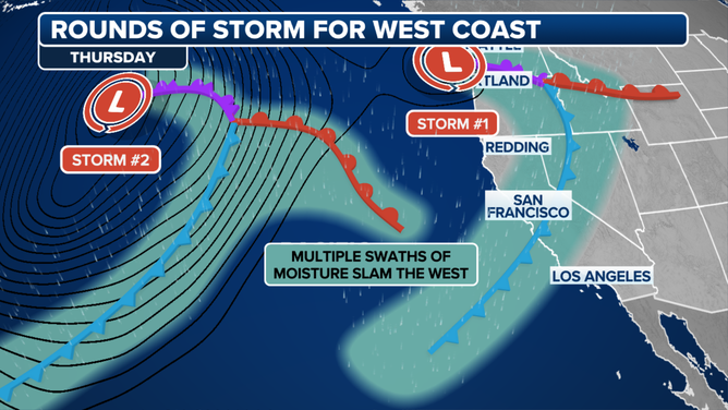
Stronger storm arrives Saturday
The first in the parade of storms is expected to move into Northern California on Saturday as a broad cold front sweeps from north to south across the state during the day. The front will bring a period of steady, moderate rain.
NOAA's Weather Prediction Center has already highlighted coastal sections of Northern California for a Level 1 out of 4 risk of flash flooding from late Friday into Saturday.

(FOX Weather)
After a brief break Saturday night, a second, even more potent storm that is more of a tropically infused atmospheric river is on track to swing through much of California from Sunday into the middle of next week.
"Several inches of rain are expected over this period, particularly in the coastal mountains," wrote National Weather Service San Francisco forecasters in their Tuesday morning forecast discussion.
For Northern California, forecasts so far suggest a combined 3-5 inches of rain expected in the coastal mountains by Monday, with 1-2 inches likely in the San Francisco Bay Area by Sunday night.

(FOX Weather)
Forecast rain totals so far for Southern California are also quite high with the pair of storms, hovering in the 2- to 5-inch range for the Southern California coast and valleys – including the Los Angeles area – with 5-8 inches predicted for the foothills and mountains. The storm is currently expected to stall and swirl off the California coast into Wednesday, keeping rain in the forecast.
"Given the amount of rain that just fell across the area, if this next storm performs as currently advertised, there is definitely the potential for significant hydrologic issues area-wide," NWS Los Angeles forecasters wrote Monday night. "And especially in the hills and mountains where another round of mud and rock slides is very likely. It's highly recommended that anyone in flood-prone areas start taking precautions now while the weather is calm."
Silver lining to the current stormy California forecast
The good news is, while these upcoming storms will likely be very wet and bring gusty winds, they are not expected to be as strong as the storms earlier in the month that brought over a foot of rain and widespread damaging wind gusts.
"There will be wind and rain with all these storms, but nothing like what we had earlier in the month," the NWS said.
STRONG WINDS CRASH TREE INTO SACRAMENTO HOME
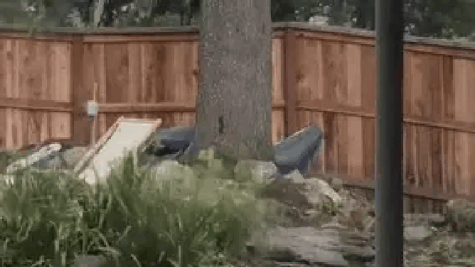
Video from Stephen Belcher shows a tree being ripped from its roots and lifting a fence in the process, before crashing down onto a home.
(Stephen Belcher via Storyful)
Los Angeles received just over 9 inches of rain as two atmospheric rivers slammed the region earlier this month – about 60% of the city's annual rainfall average. Over 500 mudslides covered Los Angeles-area roads, and dozens of homes suffered damage.
The San Francisco Bay Area had hundreds of thousands lose power during ferocious winds gusting over 70 mph, and multiple people were killed in Northern California from falling trees.
In all, 12 people have died in California from weather-related events since the stormy pattern began in late January.
El Niño still going strong … for now
The storms have been a calling card of a "Super" El Niño pattern in force through the winter. It's just the sixth time since 1950 that an El Niño has reached such strength, defined as when waters in the Central Pacific Ocean reach at least 2.0 degrees Celsius (3.8 degrees Fahrenheit) above average.
RARE ‘SUPER’ EL NIí‘O ARRIVES BUT RAPID COLLAPSE BEGINNING AS LA NIí‘A WATCH ISSUED
El Niño patterns tend to energize the southern jet stream, steering strong storms across the Pacific into California, and this El Niño has been no different. El Niño is likely on its way out soon but may not be in time to keep the rainy pattern away from California this winter.