Over a dozen dead as Christmas week bomb cyclone unleashes snow, damaging winds and brutal cold across country
The combination of dangerous driving conditions and frigid temperatures has been blamed for at least 14 deaths across 5 states.
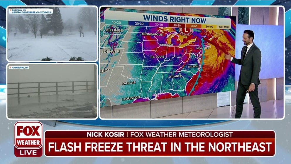
Northeast sees weekend flash freeze threat
Gusty winds and subzero wind chills will impact the Northeast on Saturday.
A dangerous blizzard intensified into a bomb cyclone Friday as it walloped the Great Lakes and Northeast with snow, damaging winds and plummeting temperatures, creating a travel nightmare for millions trying to reach their destination before the Christmas holiday.
The storm's central pressure dropped by 30 millibars in the 24 hours, officially surpassing the criteria for bombogenesis, which is a 24-millibar drop in 24 hours.
The combination of dangerous driving conditions and frigid temperatures has been blamed for at least 14 deaths in half a dozen states.
![Ohio Massive Pileup]() Image 1 of 7
Image 1 of 7One person was killed and several injured in northern Ohio during a crash involving 50 vehicles. (Mike Waldron)
![Ohio Massive Pileup]() Image 2 of 7
Image 2 of 7One person was killed and several injured in northern Ohio during a crash involving 50 vehicles. (Mike Waldron)
![Ohio Massive Pileup]() Image 3 of 7
Image 3 of 7One person was killed and several injured in northern Ohio during a crash involving 50 vehicles. (Mike Waldron)
![Oregon deadly crash]() Image 4 of 7
Image 4 of 7Eastbound lanes of I-84 near Rooster Rock State Park on Tuesday (Multnomah Co. Sheriff's Office)
![Christmas week blizzard]() Image 5 of 7
Image 5 of 7Christmas week blizzard ( )
![Armored Truck Crash]() Image 6 of 7
Image 6 of 7An armored truck ends up on its roof in Mayes County, Oklahoma. (Oklahoma Highway Patrol)
![South Dakota Snow]() Image 7 of 7
Image 7 of 7Blowing snow in Pennington County SD (Pennington County (SD) Sheriff's Office)


Three people were killed in weather-related crashes in Oklahoma, along with another three people on the slick roads in Kentucky and one person whose vehicle overturned in Missouri. One person also died in Texas after prolonged exposure to subfreezing temperatures.
At least four people were killed and several injured during a massive 50-vehilce pileup on the Ohio Turnpike, near Sandusky, Ohio. The Ohio State Highway Patrol warned of near-white out conditions and cautioned travelers to stay home.
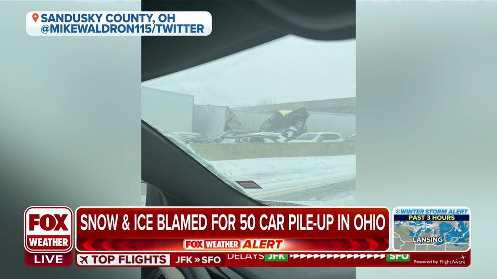
Winter storm results in 50-car pile-up in Ohio, one dead
Snow and ice blamed for a 50-car pile-up on the Ohio turnpike in Sandusky County. One person has been killed in the crash.
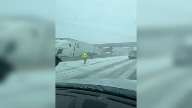
Earlier this week, deputies in the Portland, Oregon, area reported roadways were icy when a semi-truck crashed into the scene of a previous wreck on Tuesday along Interstate 84, where one man was killed.
Wind gusts that were tropical storm force and even hurricane force in some areas knocked power out to more than 1.4 million customers from Texas to Maine, with a separate ice storm causing outages in the Pacific Northwest.
In anticipation of the substantial impacts, several states issued states of emergencies to enable resources for the response to the winter storm system.
The winds knocked down trees and limbs, which damaged electrical equipment, and inflatable Christmas decoctions were no match for Mother Nature.
(FOX Weather)
The wind helped usher in bitterly cold, life-threatening air with freezing temperatures expected to reach all the way to South Florida. The cold snap could be the Sunshine State's coldest Christmas in more than 30 years.
HERE'S HOW LONG IT'LL TAKE YOU TO GET FROSTBITE AS WIND CHILLS DIP BELOW ZERO
The combination of the wind and bitterly cold temperatures caused wind chill values to reach dangerous levels across much of the eastern half of the nation.
Many of the ingredients were in place for a travel nightmare with more than 150 million Americans under some type of winter weather alert.

(FOX Weather)
Data from FlightAware showed more than 8,000 flights had been canceled across the U.S. through Saturday, and more than 20,000 flights that were delayed in a 3-day period since Wednesday.
RECORD-BREAKING, LIFE-THREATENING WIND CHILLS PLUNGE 150 MILLION AMERICANS INTO DEEP FREEZE
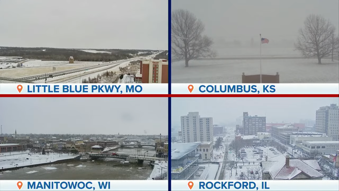
A lack of moisture from the Gulf of Mexico helped keep snow totals on the low side with the heaviest precipitation expected in communities along the Great Lakes. According to the FOX Forecast Center, more than a foot of snow could pile up in the Upper Peninsula of Michigan, western Lower Michigan, far northern Indiana and western and northern New York due to bands of heavy lake-effect snow through the weekend.
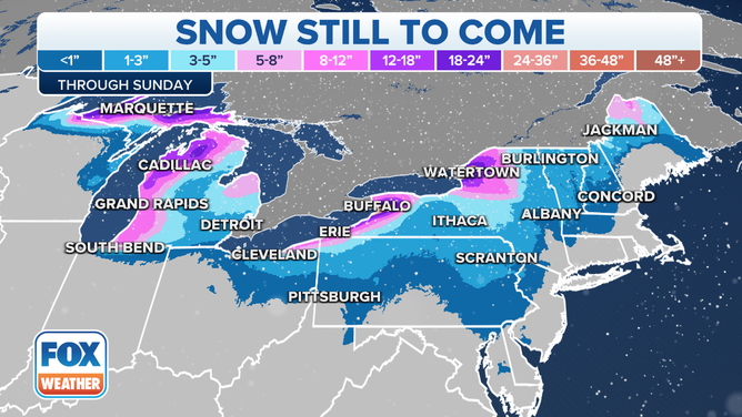
Snowfall forecast through Christmas Day.
(FOX Weather)
Snow accumulations elsewhere will likely be under 6 inches, except for some locally higher totals from the Adirondacks of New York to the Green Mountains of Vermont, White Mountains of New Hampshire and parts of northern Maine.
FROM 50 DEGREES TO BELOW ZERO: ARCTIC FRONT SENDING INSTANT BONE-CHILLING BLASTS OF FRIGID AIR
The winter storm reached its peak intensity Friday over the Great Lakes but occasional blizzard conditions will continue to snarl travel from the Upper Midwest eastward to portions of Michigan and western and northern New York, into the weekend.
According to the FOX Forecast Center, the high winds will likely contribute to thousands of additional power outages across the Great Lakes and Northeast, which could turn into a life-threatening situation for those who lose power amid such frigid temperatures.

(FOX Weather)
WHAT ARE THE WORST AIRPORTS TO FLY INTO DURING WINTER?
Additionally, for coastal communities from the Delmarva Peninsula through Maine, onshore winds could continue to lead to significant coastal flooding threat along south-facing coastlines during periods of high tide. The FOX Forecast Center said the flood levels could potentially rank among the 10 highest on record along portions of the Northeast and New England coasts.
NORTHEAST COASTAL FLOODING FROM CHRISTMAS BLIZZARD COULD REACH 3 FEET BY FRIDAY'S HIGH TIDE
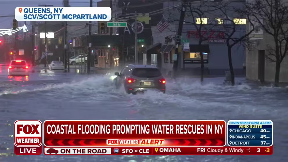
Queens, New York experiencing coastal flooding leading to water rescues
FOX Weather's Katie Byrne is in Queens, NY where they have seen a substantial amount of flooding on Friday, leading to water rescues.
Christmas weekend: Feet of snow to bury Great Lakes snowbelts
On Christmas Eve, the winter storm will exit into eastern Canada, but high winds will continue to impact the Upper Midwest, Great Lakes and parts of the Northeast. As those winds blow over the lakes, intense lake-effect snow bands are expected to develop in the Great Lakes snowbelts and dump heavy snowfall in localized areas through at least Christmas Day.
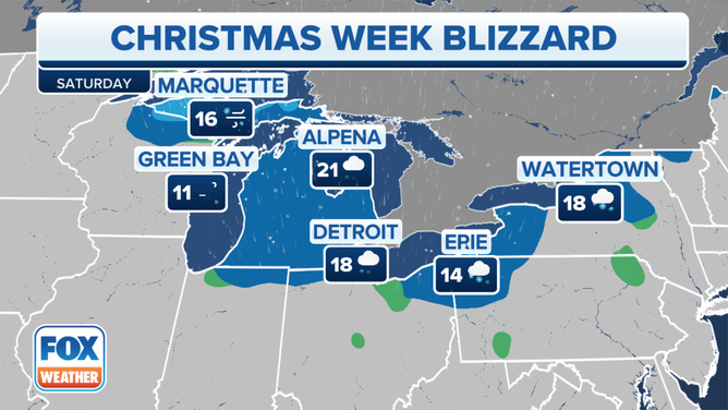
Forecast for Saturday, Dec. 24, 2022.
(FOX Weather)
Buffalo, New York, has been placed under a Blizzard Warning due to the combination of heavy lake-effect snow and high winds.
"High confidence continues for expected blizzard conditions downwind of both Lake Erie as well as for Jefferson County off Lake Ontario," the National Weather Service office in Buffalo wrote in a forecast discussion. "The expectation is that the combination of heavy lake-effect snow and very strong winds will produce blizzard conditions across the Niagara Frontier starting (Friday) afternoon and lasting into Saturday night, with these same blizzard conditions starting in Jefferson County by (Friday) afternoon and lasting into Sunday morning."
BUFFALO BLIZZARD CAUSES WHITEOUT CONDITIONS, TRAVEL BANS AHEAD OF CHRISTMAS WEEKEND
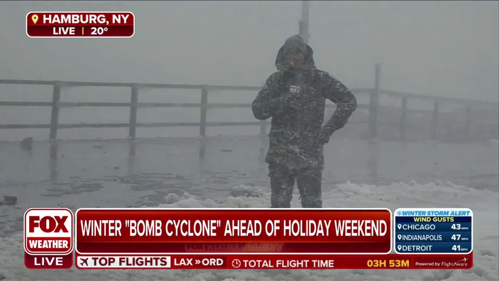
Travel ban in place for Erie County, city of Buffalo as conditions continue to deteriorate
A travel ban is in place for Erie County and the city of Buffalo in western New York. FOX Weather's Max Gorden reports from along the shores of Lake Erie in Hamburg, NY.
According to the FOX Forecast Center, snowfall amounts through Monday will range from 1 to 4 feet not only across western and northern New York, but also in the Upper Peninsula of Michigan and western Lower Michigan.
The lingering gusty winds will also continue to produce dangerously cold wind chills throughout Christmas weekend, which could seriously threaten anyone who remains without power.
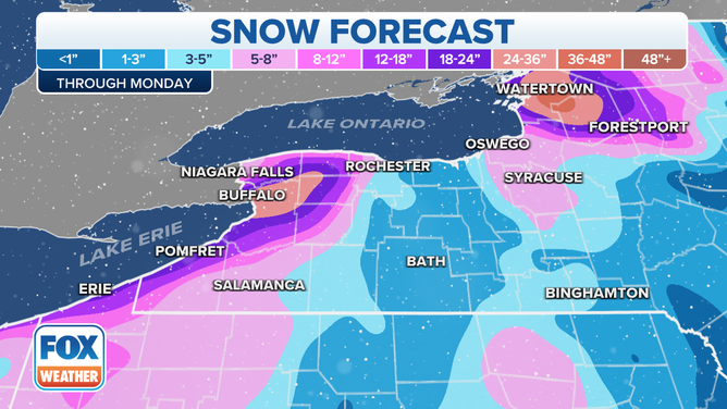
Lake-effect snow forecast through Monday, Dec. 26, 2022.
(FOX Weather)