Northeast costal flooding from Christmas blizzard could reach 3 feet by Friday's high tide
Forecasters are warning of nearly 3 feet of storm-surge inundation in some places, like Portland, Maine, due to the powerful winds produced by the storm that formed into a bomb cyclone Friday morning.
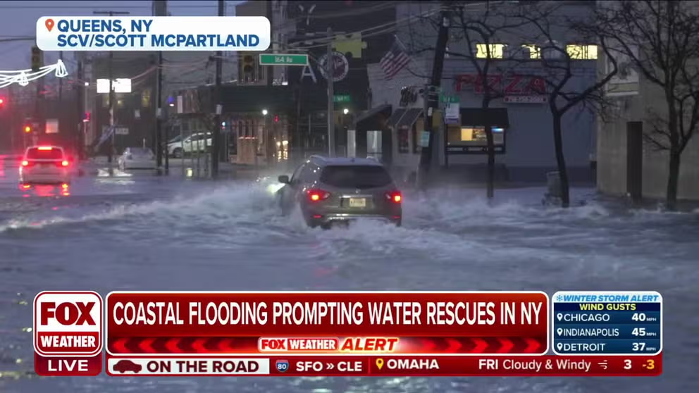
Queens, New York experiencing coastal flooding leading to water rescues
FOX Weather's Katie Byrne is in Queens, NY where they have seen a substantial amount of flooding on Friday, leading to water rescues.
Heavy rain from a powerful winter storm moving across the country could lead to some coastal flooding concerns along much of the Northeast and New England coasts Friday, especially where snowmelt adds to the water falling from the sky.
HUNDREDS OF THOUSANDS WITHOUT POWER AS DEADLY CHRISTMAS WEEK BLIZZARD INTENSIFIES INTO BOMB CYCLONE
The National Weather Service in New York said widespread moderate to locally major coastal flooding is ongoing Friday.
Areas on the south shore of Long Island neared peak levels by late morning. As high tide approaches, areas on the Long Island Sound will rise for the next few hours.
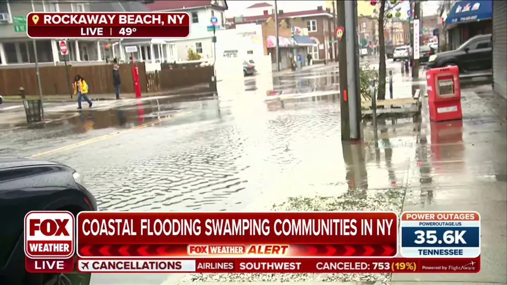
Coastal flooding swamping neighborhoods in the Rockaway Beach community
FOX Weather's Katie Byrne is in Rockaway Beach, New York showing the coastal flooding in the community.
Forecasters are warning of nearly 3 feet of storm-surge inundation in some places, like Portland, Maine, due to the powerful winds produced by the storm that formed into a bomb cyclone Friday morning.
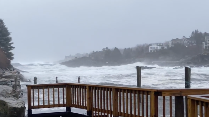
Coastal flooding in Ogunquit, Maine on Dec. 23, 2022 during a Christmas week winter storm that morphed into a bomb cyclone. (Image: BeachmereInn/Twitter)
(FOX Weather)
According to the NWS, this would be the third-highest water level on record in Portland, behind a February 1978 blizzard and a nor'easter one-month prior.
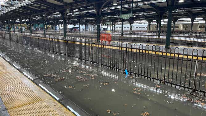
![Hoboken Terminal in New Jersey was flooded on Dec. 23, 2022 causing delays across NJ Transit. (Image: NY TRANSIT/Twitter)]() Image 1 of 6
Image 1 of 6Hoboken Terminal in New Jersey was flooded on Dec. 23, 2022 causing delays across NJ Transit. (Image: NY TRANSIT/Twitter) ( )
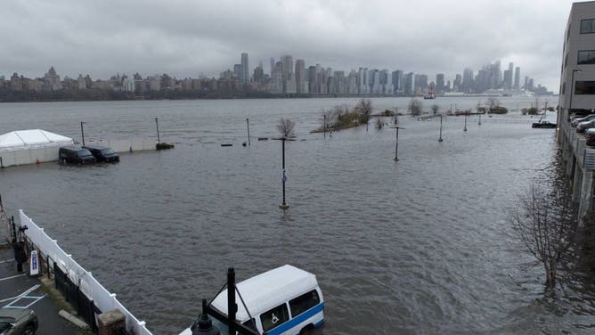
![The Hudson River spills over a river wall in front of the skyline of lower Manhattan in New York City during an extreme high tide on December 23, 2022, in Hoboken, New Jersey.]() Image 2 of 6
Image 2 of 6The Hudson River spills over a river wall in front of the skyline of lower Manhattan in New York City during an extreme high tide on December 23, 2022, in Hoboken, New Jersey. (Photo by Gary Hershorn/Getty Images) ( )
![Flooding at the NJ Transit Hoboken station on Dec. 23, 2022 due to the winter storm.]() Image 3 of 6
Image 3 of 6Flooding at the NJ Transit Hoboken station on Dec. 23, 2022 due to the winter storm. (Image: Michelle Romano/FOX Weather) ( )
![Hoboken Terminal in New Jersey was flooded on Dec. 23, 2022 causing delays across NJ Transit.]() Image 4 of 6
Image 4 of 6Hoboken Terminal in New Jersey was flooded on Dec. 23, 2022 causing delays across NJ Transit. (Image: NY TRANSIT/Twitter) ( )
![]() Image 5 of 6
Image 5 of 6Flooding was reported as high tide approaches in Rockaway Beach, New York. Some areas could see 3 feet of flooding depending on the strength and direction of winds at high tide. ( )
![Storm clouds are seen as the Hudson River spills over a river wall in front of the skyline of lower Manhattan in New York City during an severe flooding due to the winter storm in New Jersey, United States on December 23, 2022.]() Image 6 of 6
Image 6 of 6Storm clouds are seen as the Hudson River spills over a river wall in front of the skyline of lower Manhattan in New York City during an severe flooding due to the winter storm in New Jersey, United States on December 23, 2022. (Photo by Lokman Vural Elibol/Anadolu Agency via Getty Images) ( )


The forecast calls for water to enter and flood businesses along and near the Portland Pier. Water will be nearly two feet deep along Granite Point Road in Biddeford and Mile Stretch Road will be flooded. Roads and businesses will also flood in Wells and Kennebunkport, the NWS said.
Most locations covered by coastal flood alerts will see up to 2 feet of flooding.

(FOX Weather)
Coastal Flood Warnings and Advisories are impacting those along the Eastern Seaboard and extending south into places like the Delmarva Peninsula.
"Places like Long Island, as well as the Gold Coast of Connecticut, all will see likely some coastal flooding at this point," FOX Weather meteorologist Jason Frazer said. "Part of the reason why is we're going to have that onshore flow there."
The strong onshore winds at the coast will lead to a flood event along south-facing coasts, especially with the Friday morning high tide.

(FOX Weather)
The FOX Forecast Center said wind-driven rain is expected across the mid-Atlantic and Northeast on Friday as damaging winds blast the region with widespread 50-plus-mph gusts. Some gusts between 60 and 70 mph cannot be ruled out. In addition, scattered power outages are likely for parts of the Northeast, and more widespread outages are possible in interior portions of the region. More than a million people were already without power from Texas to the East Coast on Friday morning.
Even after the rain ends, the dangers will not end. Rapidly dropping temperatures will quickly freeze up any water that remains on the roads, leading to treacherous driving conditions from Friday night into at least Saturday.

(FOX Weather)