Coast-to-coast storm comes to an end after delivering gusty winds to Northeast, Midwest
The damaging winds caused by a massive coast-to-coast storm that brought impacts to more than 30 states from the Northwest to the Northeast are easing up on Saturday after reports of 60+ mph winds in the East and 100+ mph winds in the Upper Midwest.

Recapping the Coast-to-coast storm that brought gusty winds, blizzard conditions, fire threat
A coast-to-coast storm that brought impacts from the Northwest to the Northeast has finally come to an end. The storm brought heavy rain and power outages to the Northwest, snow and blizzard conditions along with 120+ mph wind gusts to the Midwest, a fire threat to Colorado and strong gusty winds and rain to the Northeast. We're taking a look back at the storm's impacts.
The damaging winds caused by a massive coast-to-coast storm that brought impacts to more than 30 states from the Northwest to the Northeast are easing up on Saturday after reports of 60+ mph winds in the East and 100+ mph winds in the Upper Midwest.
From Wednesday to Friday, the Coast-to-Coast storm brought damaging winds, heavy snow, travel issues, fire, heavy rain and even tornado warnings across the country.
This powerful storm passed through the Midwest after powerful wind gusts left hundreds of thousands of customers without power across the Pacific Northwest, Northern Plains and the Rockies on Wednesday.
Numerous wind gusts in excess of 100 mph were reported across the Intermountain West and Northern Plains since Wednesday, including a 144 mph gust on Mount Coffin, Wyoming.
A wind gust of 78 mph Wednesday set a new December wind record in Glasgow, Montana.
TWO KIDS WAITING FOR THE BUS CRITICALLY INJURED DUE TO STRONG WINDS IN IDAHO
Two children were critically injured in Twin Falls, Idaho, Wednesday, after high winds toppled rotting trees onto them while they were waiting for the bus, officials said.
The sheriff's department in Kootenai County, Idaho, said a falling tree killed a man sleeping in his home in Fernan Lake Village Wednesday afternoon and warned people to stay away from large trees during high wind events.

Strong winds impacted Twin Falls, Idaho on Wednesday, with wind gusts registered between 50 to 60 mph. Early Wednesday morning, high winds caused several old, internally rotten trees to fall, knocking down power lines, and critically injuring two children who were waiting for the bus.
(Twin Falls County Sheriff's Office / FOX Weather)
High winds also drove the spread of several large wildfires in South Dakota, Wyoming and Colorado Wednesday.
EVACUATIONS SPREAD FROM FIRES IN SOUTH DAKOTA, WYOMING DUE TO STRONG WINDS FROM COAST-TO-COAST STORM
Evacuations were issued as a wildfire grew to at least 200 acres in Pennington County, South Dakota.
Wildfires outside of Cheyenne, Wyoming and a massive blaze that reached 40,000 acres in Yuma County, Colorado, also prompted evacuations Wednesday.
Multiple spinous and inclement weather conditions have also resulted in the closure of Interstate 82 between Ellensburg and Yakima, Washington. It's unknown when the road will reopen.

Crews battle a brush fire that has already spread 150 acres in South Dakota.
(Pennington County Sheriff's Office / FOX Weather)
More than 100,000 customers were without power across Colorado early Thursday as strong wind gusts continued to pound the state.
High Wind and Fire Weather Warnings remained across the Intermountain West Thursday as dry air rushed in to fill the space behind the storm.
Meanwhile, high winds and heavy rain exacerbated last week's historic flooding in Washington. Powerful wind gusts compounded the existing power outages caused by the ongoing flooding across Washington early Wednesday.
A 71 mph wind gust was clocked at Naval Air Station Whidbey Island in the Puget Sound, and a 138 mph gale was recorded on Mount Hood, Oregon.
Power outages impacted more than 350,000 customers in Washington and another 200,000 in Oregon at the height of the storm early Wednesday.

Emergency crews worked to repair the levee using "super sacks" filled with sand.
(City of Pacific, Washington / FOX Weather)
WHAT YOU SHOULD KNOW ABOUT BLOWING, DRIFTING SNOW
As the storm marched east, these powerful wind gusts caused delays at airports as holiday travel began to increase on Thursday.
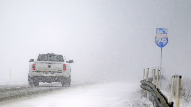
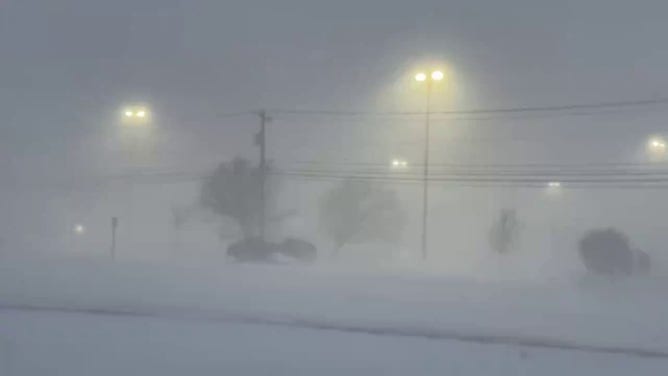
Blizzard Warnings were issued for parts of North Dakota and Minnesota, with periods of whiteout driving conditions.
Farther south, this powerful coast-to-coast storm delivered heavy rain to the Central Plains before expanding into the Mississippi and Ohio Valleys Thursday night.
![Snow falls across Chicago.]() Image 1 of 4
Image 1 of 4Snow falls across Chicago. (Robert Ray/FOX Weather)
![Cars drive in near whiteout lake-effect snow on Interstate 79 on December 12, 2024 in Erie, Pennsylvania.]() Image 2 of 4
Image 2 of 4Cars drive in near whiteout lake-effect snow on Interstate 79 on December 12, 2024 in Erie, Pennsylvania. (Jeff Swensen/Getty Images)
![A photo from Cheektowaga, New York, shows whiteout conditions due to heavy snow and wind. Portions of the Great Lakes region, including Buffalo and Watertown, could pick up feet of snow due to relentless bands of lake-effect snow.]() Image 3 of 4
Image 3 of 4A photo from Cheektowaga, New York, shows whiteout conditions due to heavy snow and wind. Portions of the Great Lakes region, including Buffalo and Watertown, could pick up feet of snow due to relentless bands of lake-effect snow. (Mark Sudduth)
![This image shows the Chicago skyline ahead of a winter storm on Wednesday, Feb. 12, 2025.]() Image 4 of 4
Image 4 of 4This image shows the Chicago skyline ahead of a winter storm on Wednesday, Feb. 12, 2025. (Robert Ray)


WINTER STORM WARNING EXPLAINED: WHAT DOES IT MEAN AND WHEN IS IT ISSUED?
Wind gusts in excess of 50 mph and snow remained the main concern for both drivers and those traveling by plane across the Dakotas, Minnesota and Iowa.
Early morning rain turned into snow by Thursday afternoon across the Dakotas, Minnesota and Michigan, and whiteout conditions were again the main travel issue through Thursday night.

Snow began to fall across Cincinnati on Friday, Dec. 12, 2025. Public schools were canceled.
(Katie Byrne/FOX Weather)
WHAT ARE THE WORST AIRPORTS TO FLY INTO DURING WINTER?
Meanwhile, the cold front delivered rain on Thursday to areas farther south in the Midwest, as well as the Mississippi River and Ohio Valleys, as the storm caused delays across a swath of airports across the central U.S.
The final leg of the storm reached the East Coast Thursday night into Friday, as the strong cold front swept through the region.

FILE - NEW YORK, UNITED STATES - OCTOBER 12: A man holding an umbrella battles with powerful winds and heavy rain during the powerful nor'easter at the Brighton Beach, in Brooklyn, New York, United States on October 12, 2025. New York Governor Kathy Hochul declared a State of Emergency for eight counties of the state and canceled the Columbus Day Parade in New York City after urging New Yorkers to continue to prepare as a strong coastal storm is set to impact much of New York beginning Sunday afternoon.
((Photo by Selcuk Acar/Anadolu via Getty Images) / Getty Images)
Across the Northeast, periods of heavy rain and strong wind gusts caused air travel disruptions across some of the country's busiest airports.
Wind gusts of 60+ mph pummeled the Northeast, with a top report of 68 mph in New London, Connecticut.