American artist James Niehues turns ski maps into masterpieces
While apps have become go-to methods for navigation, Niehues provides a different path with hand-painted maps. He creates a blend of cartography and artistry that help skiers and art-lovers alike navigate and appreciate the natural world.
Meet the trail map artist who helps skiers navigate the slopes
For more than three decades, James Niehues has blended cartography and artistry to create ski trail maps that are appreciated for their beauty as well as their usefulness.
Maps are often seen as purely functional: open an app, get directions and then close it out. Done.
While apps and smartphones have become go-to methods for navigation, one artist has created a legacy by providing a different path – and one with a more human touch.
For more than three decades, James Niehues has hand-painted maps of snowy mountains and ski slopes that have become famous in (and outside of) the sport of skiing.
Niehues creates a blend of cartography and artistry that help skiers and art lovers alike navigate and appreciate the natural world.
Creating a legend
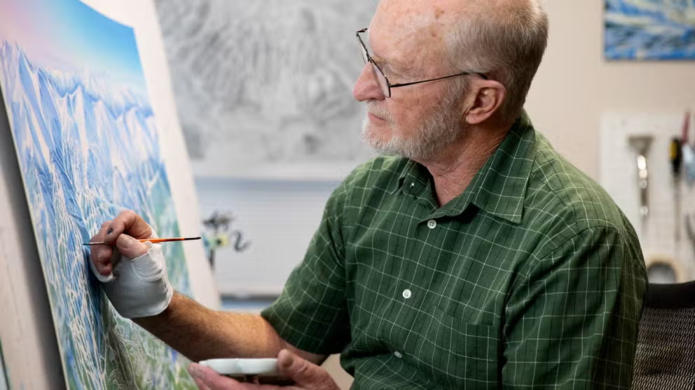
Artist James Niehues has spent over three decades hand-painting ski maps.
(James Niehues)
Hailing from the western slope of Colorado, Niehues is no stranger to nature.
"I grew up with the scenery," he said. "I've always been just infatuated with it, and it became my passion."
That passion turned into a career – 35 years and counting – of turning trail maps into works of art. Every line and every drop of color on the maps are applied by hand, as was done by Niehues's predecessors.
"There's a lot of history involved, but there's more than that," he said.
According to Niehues, creating maps the modern way with computers and computer-generated images doesn’t connect with the great outdoors.
Niehues carries on the tradition of hand-painting maps, with his chosen medium being watercolors.
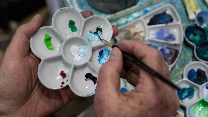
Niehues uses watercolor to paint his maps.
(Lindsay Pierce Martin)
"Whenever I use a brush, for instance, that brush is flexible, and it has different amounts of water in it," he said. "So that whenever I'd make a stroke, it isn't a digital image, it's a brush image, and it shows some distinction and flows with nature."
HOW EXPERTS ‘FORECAST’ THE COLOR TREND OF THE YEAR
Another benefit of hand-painting the maps involves perspective, particularly an oblique one.
Unlike most landscape paintings that capture a scene as-is, Niehues’s maps are a fusion of capturing both the scene and a view that’s most beneficial for skiers navigating the slopes.
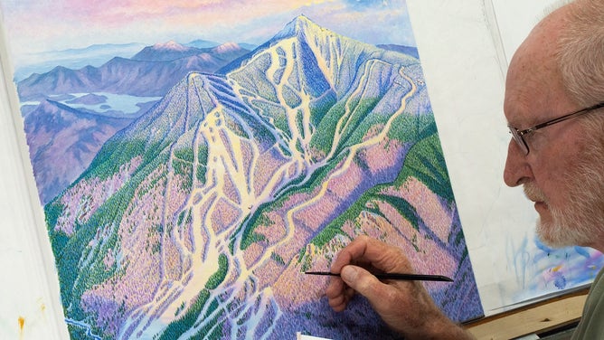
Niehues's ski map captures the slopes in Breckenridge, Colorado.
(James Niehues)
This fusion "bends" the view of the mountains, as everything in a scene is turned toward the viewer and made to look three-dimensional.
Niehues envisions this perspective and paints it.
"I translate, which a computer doesn't do," he said. "I feel very strongly that the very best way to do an oblique perspective map is by hand and through our computer: the brain."
Scaling the mountain
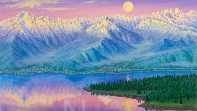
Niehues's painting of the Olympic Mountains in Washington.
(James Niehues)
Before Niehues bends an image in his mind or makes the first brushstroke, he takes a few steps to become familiar with the area he’ll paint.
First, he’ll have a resort send him plans for the ski area, which include details such as locations of ski lifts.
Then, Niehues visits the area himself, taking pictures of it from the perspective of a skier and from high above in a plane.
"The aerial photography is really the background for the information that I work with," he said.
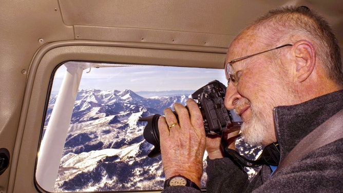
Niehues photographs the Alps.
(James Niehues)
HOW ICE TRANSFORMS THE LANDSCAPE
He begins at an altitude of about 2,000 feet, taking pictures above the summit and taking panoramic shots from different perspectives.
Next, he drops the plane to altitudes of 500 feet and below, taking detailed shots of a mountain from each altitude and, lastly, from the base of the mountain.
"Once I have all these photographs, then I'll put them together and basically work with just laying out the lift configuration first," he said.
"Then I'll refer to all the aerial photography and do a very comprehensive sketch."
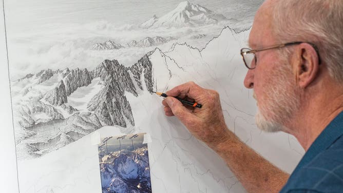
Niehues references a photograph as he sketches Washington's Colchuck Peak.
(James Niehues)
The sketch is sent to a client for approval. Once approved, the sketch is transferred to a painting surface.
Then, Niehues applies watercolors.
"I’ll start out with the sky, which is airbrushed, and then move down and airbrush all the surface of the snow," he said.
"Once that's done, then I switch to a brush and start in with the trees and the distance, the horizon," he added. "I work that in and work forward and work down."
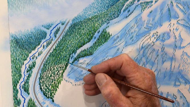
Niehues paints each tree on one of his maps.
(James Niehues)
Once the painting is approved, Niehues scans it, provides final touch-ups and then sends the painting off to the client.
"I love doing this because it's a great big puzzle," he said. "It's very gratifying to come up with a design that the ski resort will use for a long time."
HOW SKI RESORTS MAKE THEIR OWN SNOW WHEN MOTHER NATURE DOESN'T
An American record
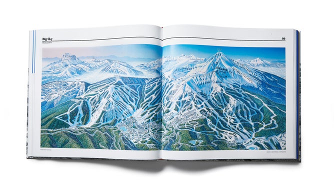
One of the maps in Niehues's book 'The Man Behind the Maps' includes a two-page spread of the Rocky Mountains in Big Sky, Montana.
(Open Road Ski Company)
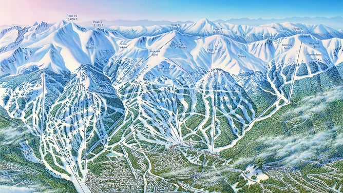
Niehues has built a portfolio of more than 430 hand-painted maps of trails and ski slopes scattered across five continents.
In 2019, over 200 of those maps were compiled and turned into a book titled "The Man Behind the Map."
Although Niehues’s story is one filled with images of snow-covered mountains and ski slopes around the world, his next chapter involves landscapes right here at home.
"The project I've been working on lately is the great 'American Landscape Project,'" he said.
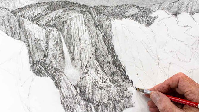
![Niehues sketches Yosemite National Park in California.]() Image 1 of 6
Image 1 of 6Niehues sketches California's Yosemite National Park for 'The American Landscape Project.' (Open Road Ski Company)
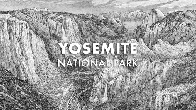
![The final sketch of Yosemite National Park in California.]() Image 2 of 6
Image 2 of 6The final sketch of Yosemite National Park in California. (Open Road Ski Company)
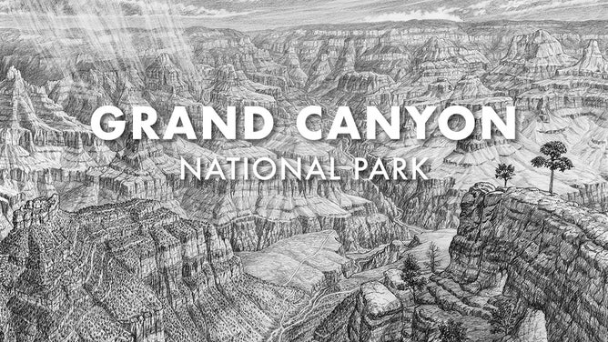
![The final sketch of Grand Canyon National Park in Arizona.]() Image 3 of 6
Image 3 of 6The final sketch of Grand Canyon National Park in Arizona. (Open Road Ski Company)
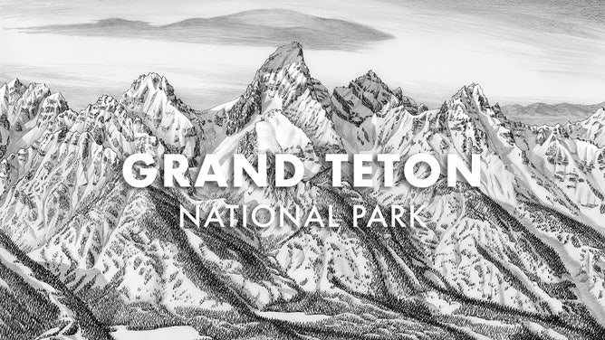
![The final sketch of Grand Teton National Park in Wyoming.]() Image 4 of 6
Image 4 of 6The final sketch of Grand Teton National Park in Wyoming. (Open Road Ski Company)
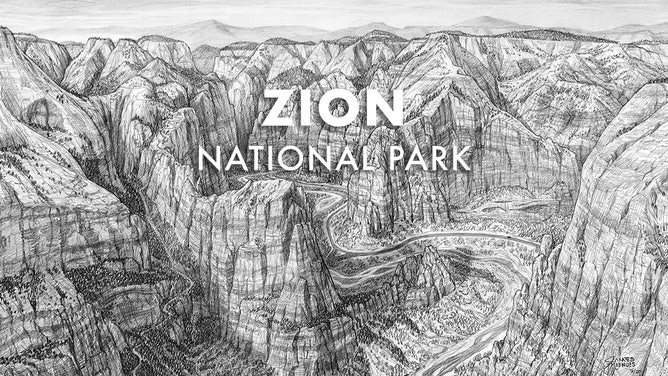
![The final sketch of Zion National Park in Utah.]() Image 5 of 6
Image 5 of 6The final sketch of Zion National Park in Utah. (Open Road Ski Company)
![James Niehues's current project is a book titled The American Landscape Project.]() Image 6 of 6
Image 6 of 6James Niehues's current project is a book titled The American Landscape Project. (Open Road Ski Company)
"I'm really, really excited about it because I can go in and just use the experience that I had in my mapmaking days to not only show a great perspective or scene, but also to kind of map it out," he added.
7 AMAZING REASONS TO VISIT YOSEMITE NATIONAL PARK
Niehues noted how he could add all the information that normally wouldn't be seen in the landscape to try to clarify the scene and what people can experience there.
A heart for art
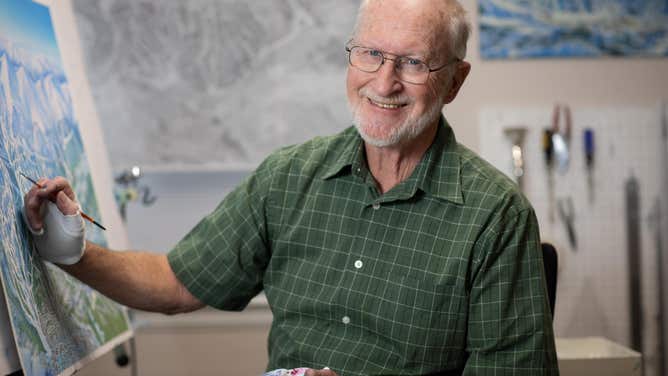
James Niehues works in his home studio in Parker, Colorado.
(Lindsay Pierce Martin)
Today, Niehues’s hand-painted maps and methods coexist with technology that attempts to rival the human element.
"It's pretty challenging to be an artist today," he said.
"You have this technology that has attracted the attention of everybody in these years, and I would just like to say that really, you need to follow your heart, if you have a passion," he added. "You just need to know that you can paint it better than you can compose it on a computer."
Niehues has followed his passion for decades and continues to build on his legacy as an artist.
"It's been just a fantastic career," Niehues said. "And I couldn't have asked for anything more."