How women helped turn mapmaking into an artform
Women made innovations in the craft of cartography, helping create a clearer picture our world
Cartography: Women who mapped the world
How women helped turn mapmaking into an artform.
Maps can show us far more than how to get from point A to point B. They tell us stories about the planet we live on and how it shapes our lives.
"Cartography is the key to understanding the world," said Judith Tyner, retired professor of geography from California State University Long Beach and author of "Women in American Cartography".
Mapmakers, or cartographers, help tell these stories by distilling the physical and figurative enormity of our world with the lines, markers and features they place on every map.
Throughout history, many of the most well-known cartographers have been men. But also furthering the craft of cartography were women, who helped turn the science of mapmaking into an art and helped create a clearer picture our world.
Early women cartographers
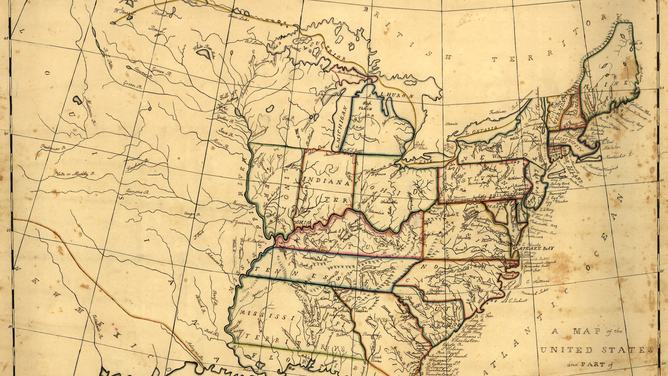
Pen-and-ink and watercolor map of the U.S., made by Mary van Schaack in ca. 1830.
(Library of Congress)
"Some of the earlier maps were indeed by men, but behind them were cohorts of women," said Will van den Hoonaard, retired professor of Sociology from the University of New Brunswick and author of "Map Worlds: a History of Women in Cartography".
The impact of these women cartographers was most evident in their artistic innovations.
One early woman cartographer lived in 4th-century China. According to Tyner, the mapmaker was the sister of the prime minister, and she embroidered a map on silk to make the map more permanent so that it wouldn't fade or get wet and vanish.
Another early woman cartographer was a Spanish nun in the 10th century. According to van den Hoonaard, she was the first female manuscript illuminator, and she blended the artistic style of her Christian faith with that of the Muslim invaders in her maps.
In the centuries that followed, maps gained even greater importance as more empires sought to navigate new worlds — and women were there to help document those discoveries.
Ladies of map production
![A 16th-century map of Europe, northern Africa and western and central Asia. Made by cartographer Mercator, who hired women to color his maps.]() Image 1 of 2
Image 1 of 2A 16th-century map of Europe, northern Africa and western and central Asia. Made by cartographer Mercator, who hired women to color his maps. (Gerardus Mercator / Royal Geographical Society)
![A 16th-century map of Asia with the eastern corners of Europe and Africa. Made by cartographer Mercator, who hired women to color his maps.]() Image 2 of 2
Image 2 of 2A 16th-century map of Asia with the eastern corners of Europe and Africa. Made by cartographer Mercator, who hired women to color his maps. (Gerardus Mercator / Royal Geographical Society)

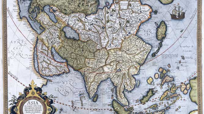
As the demand for maps soared, cartographic companies swooped in to provide their services. According to van den Hoonaard, although men were the ones with the means to own the businesses, women were often hired to perform artistic aspects of the production.
"One of the jobs that women had was applying color to the map," Tyner said. "Color is pretty useful on maps to distinguish things."
In fact, during the 16th century, cartographer Gerardus Mercator (the father of the Mercator projection) employed a group of women as colorists for his mapmaking. The use of colors became so popular that, in later times, ladies of high society would participate in coloring maps as a hobby.
Come the 18th century, women began to work in a new part of map production: engraving, an early form of printing. According to Tyner, early women engravers would scribe images and words of a map into a plate of copper. That copperplate was then pressed onto paper to print a map.
According to van den Hoonaard, one of the most notable engravers was Eliza Colles. The daughter of cartographer Christopher Colles, Eliza became America’s first copper plate engraver at just 13 years old.
Miss Independent
Map made by Anna van Westerstee Beek. After her divorce, she took over her husband's cartography business.
(Library of Congress)
Women would participate in other parts of production, such as embroidering maps and stitching together atlases.
While these tasks gave them the opportunity to showcase their talents, they also gave a certain group of women something more.
"They were sometimes described as wives, widows and spinsters — a woman who was widowed and had no money," Tyner said.
Cartography gave widows the chance to stand on their own two feet.
"They could get their own income, very good income, and were independent in many ways," van den Hoonaard said.
"This gives a lot of respect and prestige."
Science begets art begets science
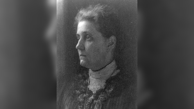
Jane Addams, who co-founded the social settlement of Hull House in 1889 Chicago. Jane Addams also used maps as a form of social activism.
(Water, Ed. D. / Prints and Photographs Division, Library of Congress)
For some early women cartographers, prestige also came from, not just the art of mapmaking, but from the discoveries they made while creating maps.
At the turn of the 19th century, Americans Jane Addams and Alice Sinclair Holbrook made neighborhood maps.
"These were socially significant maps made by women for suffrage and showing where women had the vote, where they didn't," Tyner said.
Another American woman, Marie Tharp, worked with her husband to map the ocean floor in the mid-20th century.
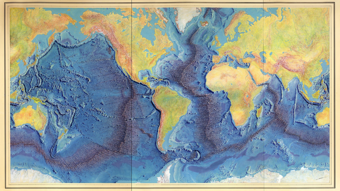
A painting of the Heezen-Tharp map "World Ocean Floor".
(Library of Congress, Geography and Map Division)
According to van den Hoonaard, "she discovered undersea mountains, and that led her to conclude about the continental drift."
Tharp based her idea on the presence of those mountains, particularly the Mid-Atlantic Ridge that cuts down the middle of the Atlantic Ocean. People were initially skeptical of her proposal, but were later convinced.
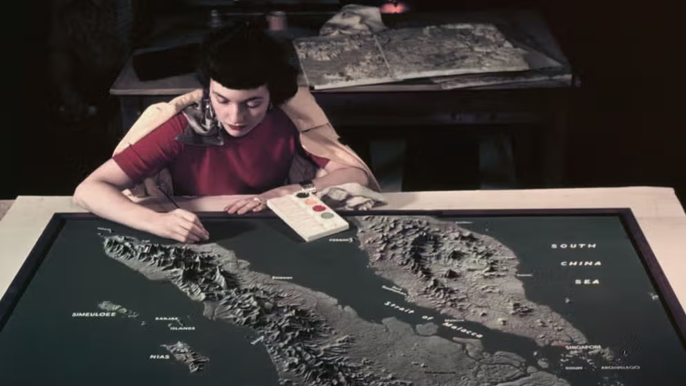
Women and maps
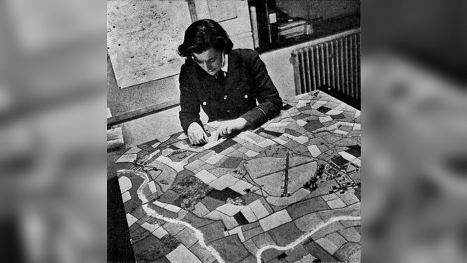
The Women's Auxiliary Air Force, working on a pictorial map at a Bomber Station during World War II.
(Culture Club / Getty Images)
Maps are created by years of exploration and discovery, combined with the science and art of cartographic work.
By working behind the scenes — and sometimes in front — generations of women have created countless images that helped map readers explore and understand their world.
"We need to show that yes, women can do science. Women can read maps, can make maps, and that they have been doing it for centuries," Tyner said.