What is a microburst?
A microburst is an incredible downdraft that spills forth from the belly of thunderstorms.
What is a microburst?
Like an atmospheric water balloon, a microburst is an incredible downdraft that spills forth from the belly of thunderstorms.
There's drizzle, light rain, moderate rain, heavy rain, scattered showers, and mist -- all forms of precipitation that will leave you in various degrees of wetness.
And then there's the microburst, where if you're unfortunate to get caught in one of these, you might be wringing yourself out for hours.
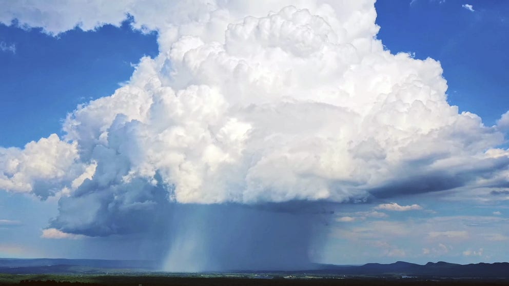
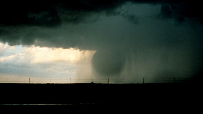
A supercell thunderstorm produces a downburst, May 8, 2017 in Elbert County near Limon, Colorado.
(Drew Angerer / Getty Images)
A microburst is a type of downburst, spawned from an incredible downdraft that spills from the belly of thunderstorms.
"A microburst is when a thunderstorm is kind of falling apart and decaying and the updraft kind of collapses, and that means all of the air rushes down from the thunderstorm to the ground, and you have this massive burst of air," says FOX Weather Meteorologist Britta Merwin.
For a microburst to develop, you need a powerful updraft, or wind flowing into a thunderstorm, that can hold back a large amount of air, rain and hail. As the air is pulled into the towering storm cools, it weakens the updraft.
The updraft then becomes unable to support that large amount of air, rain and hail it once did, so all of that drops from the skies like an atmospheric water balloon. When this "balloon" hits the ground and "pops," it sends strong wind racing out in all directions.
Or, Merwin has another example:
"Imagine a dry sink," Merwin says. "Flip on the faucet full power — that’s exactly what a microburst is in the atmosphere; you’re talking about a thin column of air that goes right own and everything goes outward, so this is a strong straight-line wind that takes out everything."
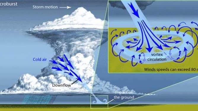
Anatomy of a microburst
(NOAA / National Weather Service)
7 FACTS YOU SHOULD KNOW ABOUT FLASH FLOODS
According to the National Weather Service, wind speeds can reach upwards of 100 mph, and in extreme cases, winds can reach 150 mph. That equates to the winds created by EF-1 to EF-3 tornadoes, strong enough to knock over hundreds of trees and cause damage to homes or other structures.
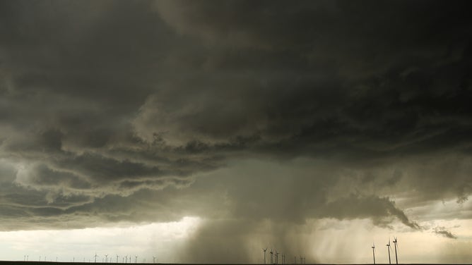
An example was a microburst that struck northern Texas as part of a line of severe thunderstorms on Feb. 26, 2023. A West Texas Mesonet wind gauge clocked a gust at 114 mph!
Microbursts are usually only felt over short distances – 2.5 miles or less. Though some more powerful ones can have impacts that reach over 2.5 miles – known as "macrobursts", or if you get a line of destructive thunderstorms with multiple downbursts, they can create a line of damaging winds stretching hundreds of miles known as a derecho.
Wet microburst vs. a dry microburst
Depending on the storm makeup, you can have a wet microburst or a dry microburst.
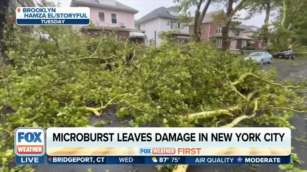
Microburst leads to 70 mph wind gusts, tree damage in Brooklyn, New York
Sudden wind gusts to 70 mph swept through Brooklyn Tuesday evening as severe thunderstorms rolled through, toppling trees in several neighborhoods. We explain how a microburst works and how it is different than a tornado.
A wet microburst is when a substantial amount of rainfall (and hail!) comes along for the ride.
Think of all the rain and ice that can be carried in tall thunderstorm clouds and then essentially wringing much of it out all at once. The result is much closer to a literal sense of an atmospheric water balloon: A massive wall of water drops from the sky, then races outward in all directions, carried by the strong winds.
(NOAA Legacy Photo ERL/WPL / NOAA)
Being inside a microburst is quite the surreal experience with sudden ferocious winds and a rain intensity that is among the heaviest you'll see -- almost as if you're being pelted with the drenching power of a million water balloons simultaneously. Forecasters may talk of rain "showers" -- this is like being at the end of a hose.
A fire hose.
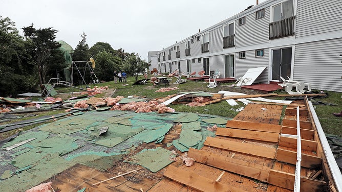
WEST YARMOUTH, MA. - JULY 23: Debris behind the Cape Sands Inn, where the roof was blown off after a tornado touched down on July 23, 2019, in West Yarmouth, Massachusetts.
(Matt Stone/MediaNews Group/Boston Herald)
Don't bother with an umbrella. It'll be useless. With that kind of wind and rainfall potential, you'll want to seek shelter immediately.
Wet microbursts can lead to flash flooding with nearly instant rainfall totals that can approach an inch or more.
Sometimes microbursts have the wind without the rain…
On the other hand, if the storm has a high cloud base and is in an area where there is a lot of dry air near the ground (like the Southwestern deserts), the rain can evaporate before it reaches the ground, and you can get what's known as a "dry microburst."
HOW TO WATCH FOX WEATHER ON TV
In this case, it's just the wind that races out in all directions, but as the name implies, it comes without precipitation.
Being caught in a dry microburst will leave you windblown and, if, in the desert areas, likely dust or sand-blasted by an accompanying dust storm. (But at least your clothes have a decent chance of staying dry.)
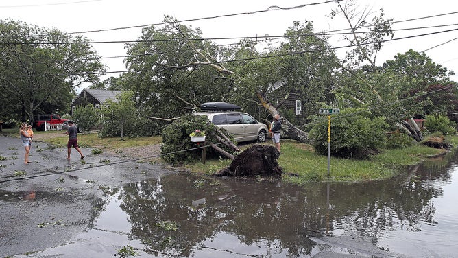
Trees narrowly miss a house and car after a microburst uproots trees on July 23, 2019 in Harwich, Massachusetts.
(Matt Stone/MediaNews Group/Boston Herald)
Either kind of microburst is an extreme danger to aviation — especially during take-offs and landings.
NWS meteorologists say a downburst can more than double the rate of descent of a plane, causing a potentially deadly outcome if near the ground.
Some airports now have wind sensors in place to help detect the presence of a microburst, and pilots and air traffic controllers work to keep aircraft away from any storms that could potentially house a microburst.