

Evacuations ongoing, states of emergency declared ahead of future Hurricane Isaias’ dangerous landfall
The NHC said it is increasingly likely that Isaias will be a significant hurricane when it reaches the northern Gulf Coast.
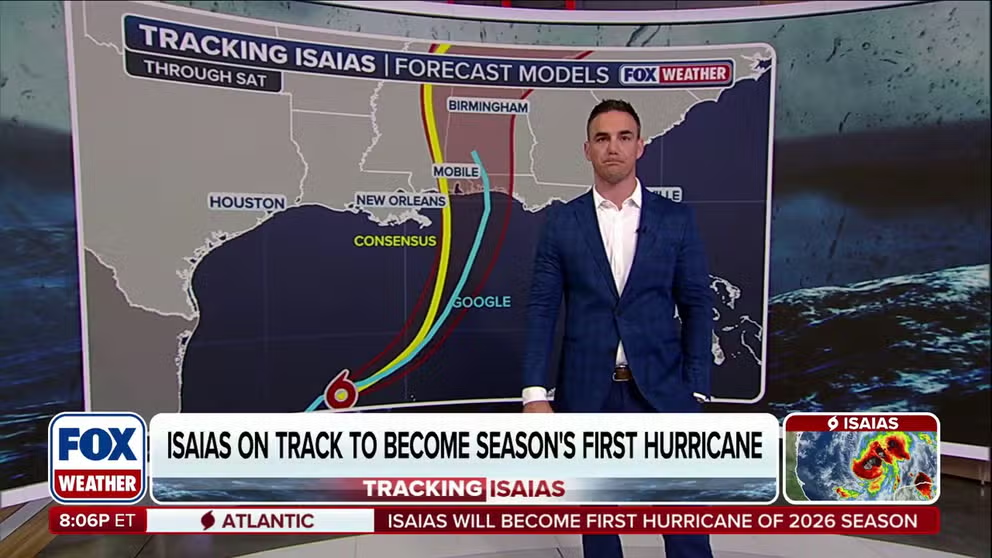
Gulf Coast braces for dangerous Isaias landfall as storm surge, flooding rain and tornadoes threaten millions
Tropical Storm Isaias is gaining strength as it races toward the Gulf Coast, putting millions on alert for dangerous storm surge, flooding and tornadoes. From Louisiana to Florida, communities are preparing for a potentially dangerous landfall. Stay with FOX Weather for the latest.
THE TAKEAWAY
- Tropical Storm Isaias has formed in the southern Gulf and is forecast to strengthen into a hurricane before making landfall along the northern Gulf Coast later this week.
- A Hurricane Warning is in effect from Ocean Springs, Mississippi, to the Bay/Gulf County Line in Florida.
- Heavy rain is expected to begin on Friday, with flash flooding, damaging wind gusts, potentially life-threatening storm surge and even tornadoes possible as the storm comes ashore.
- Landfall is currently expected sometime between late Friday and early Saturday, but uncertainty remains regarding exactly where and how strong Isaias will be at that time.
Hurricane and Storm Surge Warnings have been issued for the northern Gulf Coast as Tropical Storm Isaias continues to strengthen in the southern Gulf and is forecast to rapidly intensify into a dangerous Category 2 hurricane.
Isaias is expected to approach the coast by Friday, with landfall currently estimated to be sometime late Friday or early Saturday between Gulfport, Mississippi, and Panama City, Florida.

(FOX Weather)
Florida Gov. Ron DeSantis and Alabama Gov. Kay Ivey have declared states of emergency as Isaias takes aim at the Gulf Coast.
Meanwhile, evacuation orders have been issued for the entire west end of Dauphin Island in Alabama, as well as Zones A and B in Okaloosa County, Florida.
Today, I signed Executive Order 26-202, declaring a state of emergency for 25 counties in preparation for Tropical Depression Nine. This order ensures communities have the time and resources necessary to prepare for potential severe weather impacts to the Panhandle and Big Bend region of Florida. Floridians should have their plans in place, keep emergency supply kits fully stocked, and follow @FLSERT for weather updates and preparedness information.
— Ron DeSantis (@GovRonDeSantis) October 7, 2026
Isaias strengthened from Tropical Depression Nine in the Bay of Campeche early Wednesday and currently has sustained winds of 70 mph and is moving east-northeast at 9 mph.
The storm is both compact and moving into a favorable environment for development, which forecasters say will allow it to reach hurricane strength by Thursday morning.
According to the FOX Forecast Center, Isaias is expected to rapidly intensify with winds going from 40 mph to 75 mph between Wednesday morning and 2 a.m. Thursday. Additionally, winds are expected to ramp up and reach 110 mph between 2 a.m. Thursday and 2 a.m. Friday.

(FOX Weather)
Isaias' forecast cone shows it heading directly toward the northern Gulf Coast, with impacts centered over roughly 30 million people in Louisiana, Mississippi and the Florida Panhandle.
LATEST FROM FOX WEATHER HURRICANE SPECIALIST BRYAN NORCROSS
A Storm Surge Warning is now in effect from the Mouth of the Mississippi to Yankeetown, Florida, in the state's Big Bend region.
"The combination of a dangerous storm surge and the tide will cause normally dry areas near the coast to be flooded by rising waters moving inland from the shoreline," the NHC said.

(FOX Weather)
Currently, between 5 and 7 feet of surge is forecast for Mobile Bay and from Ocean Spring, Mississippi, to Indian Pass, Florida.
A Hurricane Watch is in effect from Ocean Spring, Mississippi, to the Bay-Gulf County line in Florida.
As well, a Tropical Storm Warning has been issued from west of Ocean Springs, Mississippi, to the Jefferson-Plaquemines parish line in Louisiana, and from east of the Bay-Gulf county line to the Aucilla River in Florida.
Heavy rain is expected to begin on Friday, with flash flooding, damaging wind gusts, potentially life-threatening storm surge and even tornadoes possible as the storm comes ashore.
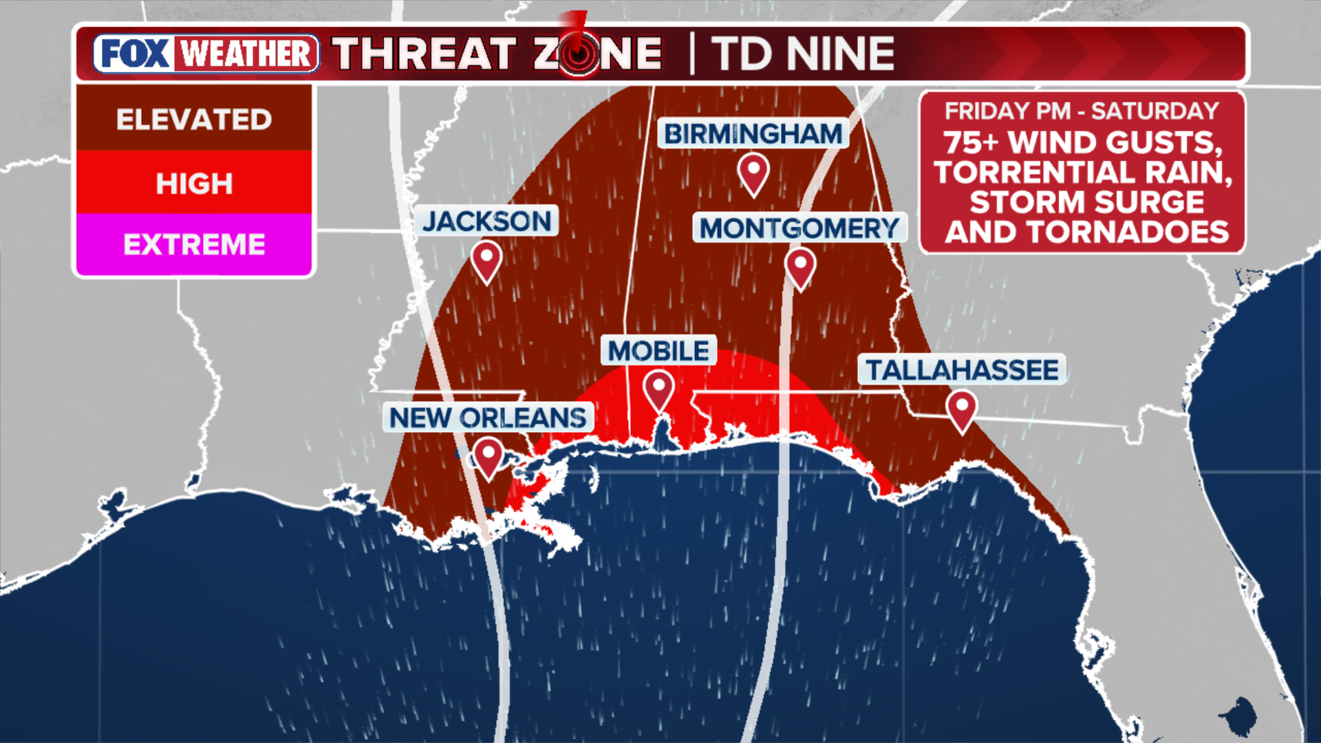
(FOX Weather)
There is still some uncertainty regarding exactly where and how strong Isaias will be at landfall.
Florida's State Emergency Response Team is beginning to stage fuel, water and food, according to the governor's emergency declaration.
Hurricane Hunters are now conducting regular reconnaissance missions into Tropical Storm Isaias, to collect the latest forecast data.
FOX WEATHER JOINS THE HURRICANE HUNTERS ON CRITICAL RECON MISSION INTO TROPICAL STORM ISAIAS
Isaias is forecast to remain in the southern Gulf for much of the day on Thursday, bringing heavy rain to the Yucatán Peninsula, before making a sharp turn towards the northern Gulf Coast as it's grabbed by a strong dip in the jet stream.

FOX Weather’s Brandy Campbell rides along with Hurricane Hunters as Tropical Storm Isaias strengthens
Tropical Storm Isaias has formed in the Bay of Campeche, and the National Hurricane Center’s forecast shows the storm strengthening into Hurricane Isaias. FOX Weather Correspondent Brandy Campbell is live with NOAA’s Hurricane Hunters as they take flight to investigate the strengthening storm.
The storm is expected to continue to strengthen and rapidly accelerate early Friday, with heavy rain reaching parts of the Gulf Coast as early as Friday morning.
"Residents from Louisiana to the Florida Panhandle should closely monitor the latest forecast updates and ensure they have their hurricane plan in place," the NHC said.
The NHC also said it is increasingly likely that Isaias will be a significant hurricane when it reaches the coast.

(FOX Weather)
FOX Weather Hurricane Specialist Bryan Norcross noted that several dynamic factors still remain at play, which will determine how strong and exactly where Isaias will make landfall, namely the storm's angle of approach and how the winds will impact the storm as it comes ashore.
TIMELINE: WHERE TROPICAL STORM ISAIAS IS HEADED AND WHEN IT COULD BECOME A HURRICANE
Some forecast models show Isaias weakening at landfall, while others show the storm strengthening as strong winds high in the atmosphere interact with it from the north.
Norcross said most of the storm's most impactful weather will most likely be on the right side of the storm's center.
Meanwhile, NOAA's Weather Prediction Center (WPC) has issued a flash flood risk for Friday across portions of Louisiana, Mississippi, Alabama, Florida, Georgia, as well as southern portions of Tennessee, southwestern North Carolina and western South Carolina.
A Level 3 out of 4 flash flood risk covers Mobile, Alabama, and the Florida Panhandle west of Panama City. A Level 2 risk includes Atlanta and Montgomery, Alabama, and eventually shifts inland into Saturday to include the Carolinas and Tennessee Valley.
"Rainfall estimates currently show 6-10 inches with localized higher amounts which will lead to flash and urban flooding and eventually river flooding," the FOX Forecast Center said.

Aerial view of the Discoverer Enterprise deepwater drillship.
(MARK RALSTON/AFP / Getty Images)
NOAA's Storm Prediction Center (SPC) has issued a Level 2 out of 5 risk of severe weather for Saturday across southern Alabama and into the Florida Panhandle, with a particular threat of tornadoes as the storm's outer bands come ashore.
Gulf water temperatures are currently at their warmest levels on record dating back to 1982. Warm waters are conducive for tropical development.

Inside Isaias: Air Force Hurricane Hunter analyzes the strengthening storm
Air Force Hurricane Hunters are tracking Isaias ahead of its potentially dangerous landfall along the U.S. Gulf Coast. Aerial Reconnaissance Weather Officer Andrew Wilson provides an inside look at the storm from the cockpit and explains how it has evolved over the Gulf.
September ended without a hurricane for the first time in 32 years, despite it being the climatological peak of the season.
The Atlantic hurricane season runs from June 1 to November 30.
This story is developing. Check back frequently for updates.